FTO 09-08-2016: Heavy Rainfall Threat Subdued; Tastes Of Fall In The Air

threat_timelineIssue Date: September 8th, 2016
Issue Time: 1:30PM MDT
Valid Dates: September 9th through September 23rd

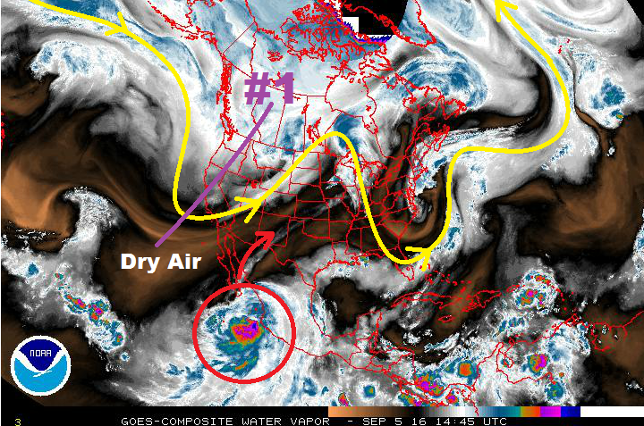
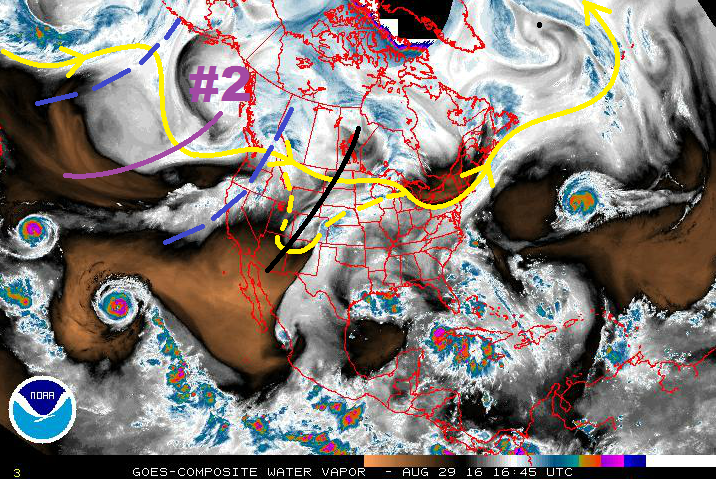
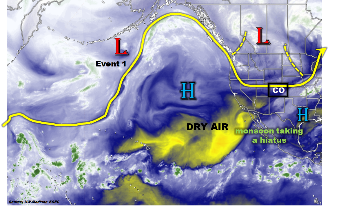
As we head into mid-September, it is certainly not uncommon to experience flood-capable rainfall anywhere the entire state. After all, atmospheric dynamics are more of a factor as the jet stream intensifies and shifts southward towards the mid-latitudes. However, the precious variable this time of year is moisture: even the most optimal dynamical setup cannot produce much of a flood threat if moisture is non-existent or marginal. Indeed, this is what we see on the large-scale water vapor image, below. A large trough with multiple embedded disturbances is centered over the Rocky Mountains. By itself, this could suggest an active weather pattern for Colorado. However, if we look farther southwest, we see that the Pacific moisture feed is non-existent as there is a wide swath of very dry air in the Pacific subtropics. This will limit short-term (1-4 days out) rainfall chances across Colorado and most of the southwest. The one exception to this is the remnants of the Tropical Storm Newton, but this moisture is racing off to the east and fortunately, will not impact our state.

wv_markup

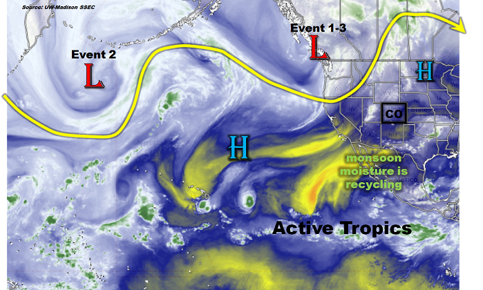
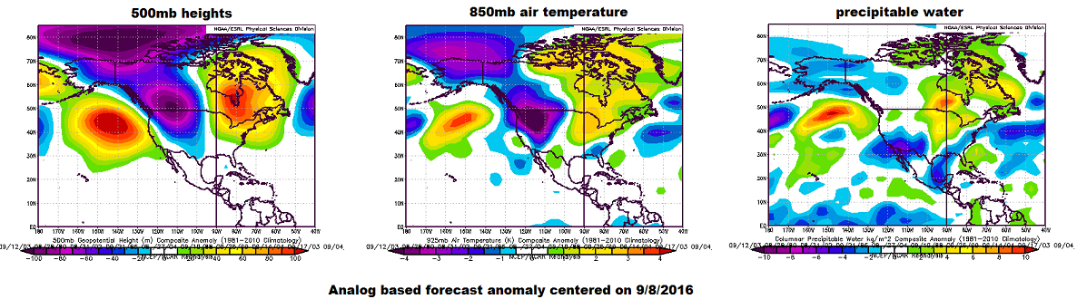
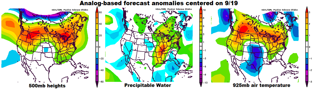
The main feature of interest during this Flood Threat Outlook appears to be the large ridge that is seen in the eastern Pacific in the water vapor image. Analog based forecasts centered on 9/16 and 9/19 indicate that this feature will maintain its strength or intensify as is slowly progresses. As the 9/19 maps show, below, this feature will eventually string out to cover the entire northern US, though maximum centers of action will be over the northwest and northeast coasts. Because Colorado lies south of the ridge, it will still see some moisture return mainly in the form of northwest flow disturbances (cool fronts) though with limited rainfall chances. There is also strong indication that a cut-off low pressure system will develop over southern California. On its eastern periphery, south/southwest flow could promote short-term surges of monsoon moisture. However, the amount of moisture return looks marginal at best and flood threat-intensity rainfall is not expected. Overall, the forecasted pattern favors limited heavy rainfall chances mainly due to limited moisture. Nonetheless, we have identified two Events that are both associated with cold front passages. Due to their quick hitting nature, No Apparent Flood Threat is seen at this time.

8-14day_analogs_3panel

Below we describe the details of the two Events.

Event #1: Monday (9/12)

No Apparent Flood Threat as a cold front sweeps through Colorado

A strong cool front will sweep into Colorado on Monday. As of right now, the timing of the front’s passage looks to coincide with peak heating, thus a round or two of thunderstorms will be possible mainly east of the Continental Divide. With rather limited moisture return in place before the front’s passage, only light to moderate rainfall amounts up to 0.75 inches are anticipated. Gusty winds and hail could accompany the stronger storms especially farther east towards the Kansas border. After its passage, expect much cooler weather with high temperatures up to 20F below normal especially east of the Continental Divide.


Legend

Event #2: Wednesday (9/14) through Friday (9/16)

No Apparent Flood Threat as the cut-off low should move east to support light to moderate rainfall

The cool down following Event #1 will be brief and by Wednesday, southerly flow will be back with temperatures near normal across the state. A cut-off low pressure system over California is expected to move east, with perhaps part of it splitting off and staying behind. Coinciding with this will be another cool front, not as strong as Event #1 that will sweep through Colorado. With enough moisture, rainfall chances will increase first over the southern part of the state, notably the San Juans on Wednesday where up to 0.5 inches of rain is possible. On Thursday and Friday, rain chances will spread northward with 0.25 to 0.75 inches of rainfall possible across large parts of the state. The highest chance for heavy rainfall appears to be in the Northeast Plains, which will have access to higher moisture and instability. Up to 1.25 inches of rainfall is possible there. However, these amounts are all below flood thresholds and an elevated flood threat is not warranted at this time.


Legend

FTO 09-05-2016: Fairly Quiet Period Overall

Issue Date: 9/5/2016
Issue Time: 11:50 PM

Threat_Timeline_20160905

This upcoming FTO period looks to be the most quiet that Colorado has experienced in quite some time. After the longwave trough (labeled #1 in the water vapor image below) passes through the region by Wednesday morning, dry air will take over as zonal flow (west-to-east) returns to Colorado. But first, let’s discuss Event #1. The aforementioned trough, which has been anchored to the western US/Canada for days now, will finally make its way to the east and weaken, bringing a slight uptick in moisture and broad-scale support for showers/thunderstorms on Tuesday. A weak surface boundary will lay across eastern Colorado, providing a focus for a few thunderstorms over the plains. Only a couple weak showers/storms are expected over the mountains, as moisture will be lacking compared to eastern regions. All in all, the storms are not expected to bring any flood threat, so Event #1 gets a “No Apparent Threat” designation. Stay tuned to tomorrow’s FTB for the latest.

WV_20160905

In Thursday’s FTO, our forecast mentioned the need to pay attention to a potential tropical cyclone off the coast of Mexico for our midweek storm chances, and one has indeed developed (red circle). “Newton,” as it is named, will recurve to the north/northeast and push into the desert southwest over the next couple of days. The westerly flow aloft will keep much of the tropical moisture associated with Newton to the south and east of Colorado, so it does not appear to bring any flood threat to Colorado at this time. This will still need to be monitored closely by the FTB, as any shift northward in the track of the moisture will have profound effects on the forecast. Stay tuned for more on that in the coming days.

Otherwise, the next chance at showers/thunderstorms will appear early next week (Mon. 12th/Tues. 13th) as an upper-level low/trough tracks across the region. At this time, it appears to be a quick-hitting event, devoid of blocking flow on either side that would slow its progression. Moisture doesn’t appear to be significant ahead of the trough, but enough may return to eastern Colorado to pose a flood threat. We will continue to monitor this situation, with an update coming in Thursday’s FTO. After this potential trough, Colorado will return to being under the influence of drier, westerly flow aloft, with quiet weather closing out this FTO period.

Event #1: Tuesday (09-06-2016)

No Apparent Flood Threat as Upper Trough Transitions Eastward

The upper trough will transition to the east, weakening/shearing out as it does so, bringing a slight uptick in moisture. Weak, broad-scale support will exist for showers/thunderstorms, above a weak surface boundary laid across eastern Colorado. The High Country and Western Slope will stay mainly dry, with only a couple isolated showers/weak storms possible along/east of the Continental Divide. The best chance for activity will be across the Southeast Plains, Raton Ridge, and far Northeast Plains. A couple storms will become strong-to-marginally severe, with strong winds and hail being the main threats. Stay tuned to tomorrow’s FTB for the latest.

Legend

Event #2: Monday (09-12-2016) and Tuesday (09-13-2016)

No Apparent Flood Threat for Quick-Hitting Event

A quick-hitting upper-level low/trough will look to track across the region early next week. Moisture doesn’t appear to be significant ahead of the trough, but enough may return to eastern Colorado to pose a flood threat. We will continue to monitor this situation, with an update coming in Thursday’s FTO.

Legend

FTO 09-01-2016: A Bit of Everything, Except Heat

Issue Date: Thursday, September 1st, 2016
Issue Time: 2:55PM MDT
Valid Dates: September 2 – September 16

threat_timeline

With today being the first day of meteorological fall, it is interesting to wonder whether the recent pattern of quite active and wet weather will persist. After all, the transition from August to September marks a generally stark downturn in precipitation for many lower elevation locations. As the North Pacific water vapor image shows, below, it does not appear that climatology will serve as a useful forecast during this Flood Threat Outlook (FTO). Instead, an active pattern is seen, as can be deduced by the waviness of the steering winds. In general, the more wavy the jet stream, the more it is capable of developing low and high pressure system capable of providing impactful sensible weather. Of particular interest for us is the large-scale low-pressure trough centered off the coast of British Columbia, draping from northern California northward through the Gulf of Alaska. This feature will be very slow to move and will serve as a focal point of all three Events identified for this FTO. Also of interest is the secondary low-pressure system much farther westward in the Pacific Ocean. A disturbance originating from this feature will eject and join the eastern trough in accentuating the active weather chances during Event #2.

wv_markup

The water vapor image is a useful diagnosis tool but unfortunately has limited forecasting value. The next set of maps, centered on September 8 ( a 7 day forecast), show an analog-based approach at forecasting anomalous weather patterns based on dynamical weather models. This method uses the forecast flow and then matches it with past flows, from which we can deduce other variables such as temperature and precipitable water. The left map below shows that the trough identified in the water vapor image is actually forecasted to persist a whole week (and even farther out, though we do not show those maps). In association with this pattern, the right two maps show that on average, this kind of pattern is associated with much below normal temperatures over the Pacific Northwest and Great Basin and below normal precipitable water over the southwest United States. Thus, even though the trough will originally have some moisture to work with, causing heavy rainfall threats #1 and #2, it will eventually bring in drier air from the subtropical Pacific (which is a nearly constant storage of such dry air). Interestingly, the cold nature of the trough suggests that the first widespread accumulating snow (though probably nothing to write home about) could occur in the Central and Northern Mountains.

analog_3panel

Of course, if everything was as straightforward as the analog maps above, our job would be easy. Unfortunately, it is not. A large wrinkle in the weather after Event #2 is what happens with the state of the eastern tropical Pacific. Almost all guidance is unanimous in developing a weak to moderate tropical cyclone that will move north-northwestward along the Mexican coastline. The problem, as related to Colorado’s weather, is whether or not this feature is absorbed in the large-scale trough or not. Such recurvature is fairly rare in the eastern Pacific, and current guidance shows that only about 10% chance of it recurving. If it tropical cyclone does not recurve and goes out to see, there will be little chance of active weather for Colorado. If it does recurve, or even gets close enough so that its moisture can be tapped, then there is a completely different story with a high potential for flood-worthy rainfall at least over the western slope. As previously stated, our current stand is the odds are against recurving and thus we have identified Event #3 as a No Apparent Flood Threat at this time. However, this is certainly one of the more interesting hit-or-miss type scenarios that we have seen this entire season. So, stay tuned!

ens_plume_recurve

Below we describe the details of the three Events identified during this Flood Threat Outlook.

Event #1: Friday (9/2) through Saturday (8/26)

An Elevated Flood Threat will focus on the western slope with some spillover possible over the Continental Divide

Enough moisture will exist over the southwest US to promote two days of scattered to widespread thunderstorm activity over the western slope. The favored region will be the San Juans due to its proximity to the moisture source. However, heavy rainfall will be possible even as far north as the southern part of the Northern Mountains (just north of I-70). Hourly rainfall rates up to 1.0 inch per hour will be capable of causing debris slides and mud flows. Isolated flash flooding will also be possible though no widespread riverine flooding is expected. By Saturday, some of the moisture and dynamics will spill over the Continental Divide and affect eastern Colorado, mainly Palmer Ridge southward. Short heavy rainfall will be possible, leading to isolated flash flooding, field and roadway flooding. Weather conditions will quite down on Sunday. Given the cool upper-level temperatures found with this system, the snow level could drop as low as 11,500 feet in the north to 12,500 feet in the south. Accumulating snows could occur during the late evening hours before precipitation winds down each day.

Legend

Event #2: Tuesday (9/6) through Wednesday (9/7)

An Elevated Flood Threat will again focus on the western slope

After a break of several days where most of the residual moisture will be used up, a smaller surge of moisture is expected from New Mexico. This will favor a heavy rainfall producing thunderstorms mainly over southern Colorado on Tuesday and Wednesday. Just like Event #1, the main threat will be short-duration (1 hour or less) rain rates up to 1.5 inches per hour east of the Continental Divide and about 1 inch per hour to the west. This will be capable of causing debris slides, mud flows and flash flooding. Wet antecedent conditions will accentuate the threat of landslides over the higher terrain.

Legend

Event #3: Thursday (9/8) – Saturday (9/10)

No Apparent Flood Threat, though everything hinges on the fate of an east Pacific tropical system

This is where things get interesting, though uncertain. If the tropical cyclone that is forecasted to be south of Baja California recurves or has enough moist outflow to be tapped by the large-scale trough, a 1-3 day spurt of very wet weather will be likely across the western slope (focused on the San Juans). This would result in up to 4 inches, or more, or rainfall over a multi-day period. However, currently the odds of this are too slim to assign it an elevated flood threat. Certainly stay tuned to the Monday FTO for a fresh look at the latest guidance.

FTO 08-29-2016: Roller Coaster Early, Coasting Late

Issue Date: 8/29/2016
Issue Time: 2:10 PM

Threat_Timeline_20160829

This 15-day period will open up active, with two elevated flood threats in the first 8 days, before quieting down with no events expected for days 9 through 15. If you take a look at the water vapor image below, the first thing you may notice is how it looks like a roller coaster; an apt description of this FTO period. Event #1 is a blend of a weakening/exiting upper-level low (black line), and the southwest flow aloft that will take shape behind the ridging (easternmost blue-dashed line) forecast to take its place. Plenty of moisture will remain behind the exiting upper-level low to bridge the gap between it and the return of southwesterly flow aloft (subtropical moisture). This moisture will keep generally unsettled weather in the forecast, but not for the same areas each day. With the transitioning upper-level pattern, different areas of the state will be favored on different days – so be sure and check back with the daily FTB forecasts.

WV_20160829

Between Event #1 and Event #2, the upper-ridge will win out, keeping the state mostly dry during those two days. A few showers/thunderstorms will still be able to develop, mainly over/near the mountains, working off of residual moisture and daytime heating. Otherwise, mostly sunny skies and generally dry conditions are expected. Event #2 refers to the next upper-level trough in the roller coaster sequence, marked by the purple line and “#2” in the water vapor image. The upper trough will be hanging around the west coast through the week and into the weekend, finally sliding across the Rockies on Monday and Tuesday (9/5 – 9/6). At this time, it appears that Gulf moisture will be transported into eastern Colorado ahead of the trough passage, setting the stage for showers/thunderstorms capable of heavy rainfall. Upslope flow in the low-levels, combined with favorable dynamics aloft, will require close watching of this event, especially for the Front Range/Southeast Mountains and adjacent lower elevations.

After Event #2, stronger ridging is expected to build across the region, bringing a much drier second half of the period. Isolated mountain showers/weak thunderstorms more capable of gusty winds than rain will be the norm of any activity, while the majority of the state dries out and warms up. We’ll keep watching this time frame for any smaller scale disturbances that may upset the dry period. Stay tuned to Thursday’s FTO.

Event #1: Tuesday (08-30-2016) through Friday (09-02-2016)

Elevated Flood Threat as Moisture Remains Through Transition

Event #1 is a blend of a weakening/exiting upper-level low and the return of southwest flow aloft. Plenty of moisture will be retained across Colorado, keeping generally unsettled weather in the forecast, but not for the same areas each day. With the transitioning upper-level pattern, different areas of the state will be favored on different days – so be sure and check back with the daily FTB forecasts.

Legend

Event #2: Monday (09-05-2016) and Tuesday (09-06-2016)

Elevated Flood Threat as Upper-Level Trough Passes through the Rockies

The upper-level trough will begin shifting eastward late in the weekend, bringing its broad-scale support for showers/thunderstorms to Colorado for Monday and Tuesday. Meanwhile, east-southeasterly low-level flow will transport Gulf moisture into eastern Colorado, providing fuel for heavy rainfall. As stated above, upslope flow combined with favorable dynamics aloft will require close watching of this event. Stay tuned.

Legend