Issue Date: 9/5/2016
Issue Time: 11:50 PM

This upcoming FTO period looks to be the most quiet that Colorado has experienced in quite some time. After the longwave trough (labeled #1 in the water vapor image below) passes through the region by Wednesday morning, dry air will take over as zonal flow (west-to-east) returns to Colorado. But first, let’s discuss Event #1. The aforementioned trough, which has been anchored to the western US/Canada for days now, will finally make its way to the east and weaken, bringing a slight uptick in moisture and broad-scale support for showers/thunderstorms on Tuesday. A weak surface boundary will lay across eastern Colorado, providing a focus for a few thunderstorms over the plains. Only a couple weak showers/storms are expected over the mountains, as moisture will be lacking compared to eastern regions. All in all, the storms are not expected to bring any flood threat, so Event #1 gets a “No Apparent Threat” designation. Stay tuned to tomorrow’s FTB for the latest.
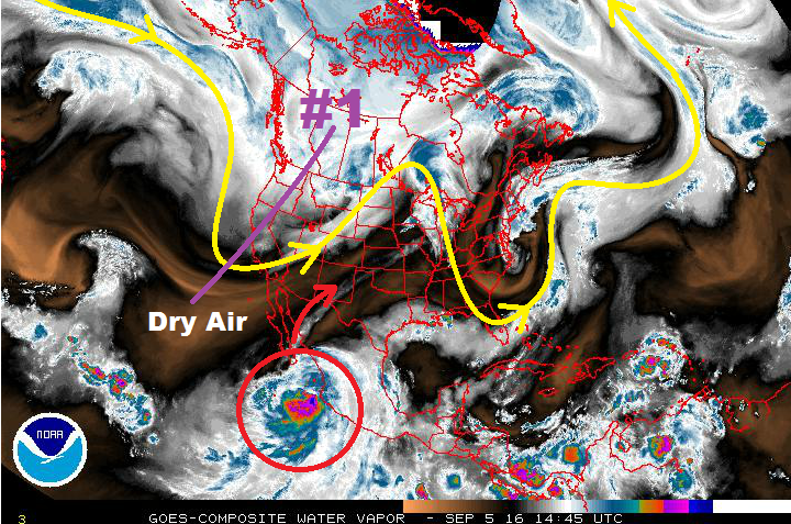
In Thursday’s FTO, our forecast mentioned the need to pay attention to a potential tropical cyclone off the coast of Mexico for our midweek storm chances, and one has indeed developed (red circle). “Newton,” as it is named, will recurve to the north/northeast and push into the desert southwest over the next couple of days. The westerly flow aloft will keep much of the tropical moisture associated with Newton to the south and east of Colorado, so it does not appear to bring any flood threat to Colorado at this time. This will still need to be monitored closely by the FTB, as any shift northward in the track of the moisture will have profound effects on the forecast. Stay tuned for more on that in the coming days.
Otherwise, the next chance at showers/thunderstorms will appear early next week (Mon. 12th/Tues. 13th) as an upper-level low/trough tracks across the region. At this time, it appears to be a quick-hitting event, devoid of blocking flow on either side that would slow its progression. Moisture doesn’t appear to be significant ahead of the trough, but enough may return to eastern Colorado to pose a flood threat. We will continue to monitor this situation, with an update coming in Thursday’s FTO. After this potential trough, Colorado will return to being under the influence of drier, westerly flow aloft, with quiet weather closing out this FTO period.
Event #1: Tuesday (09-06-2016)
No Apparent Flood Threat as Upper Trough Transitions Eastward
The upper trough will transition to the east, weakening/shearing out as it does so, bringing a slight uptick in moisture. Weak, broad-scale support will exist for showers/thunderstorms, above a weak surface boundary laid across eastern Colorado. The High Country and Western Slope will stay mainly dry, with only a couple isolated showers/weak storms possible along/east of the Continental Divide. The best chance for activity will be across the Southeast Plains, Raton Ridge, and far Northeast Plains. A couple storms will become strong-to-marginally severe, with strong winds and hail being the main threats. Stay tuned to tomorrow’s FTB for the latest.

Event #2: Monday (09-12-2016) and Tuesday (09-13-2016)
No Apparent Flood Threat for Quick-Hitting Event
A quick-hitting upper-level low/trough will look to track across the region early next week. Moisture doesn’t appear to be significant ahead of the trough, but enough may return to eastern Colorado to pose a flood threat. We will continue to monitor this situation, with an update coming in Thursday’s FTO.