Issue Date: 8/29/2016
Issue Time: 2:10 PM

This 15-day period will open up active, with two elevated flood threats in the first 8 days, before quieting down with no events expected for days 9 through 15. If you take a look at the water vapor image below, the first thing you may notice is how it looks like a roller coaster; an apt description of this FTO period. Event #1 is a blend of a weakening/exiting upper-level low (black line), and the southwest flow aloft that will take shape behind the ridging (easternmost blue-dashed line) forecast to take its place. Plenty of moisture will remain behind the exiting upper-level low to bridge the gap between it and the return of southwesterly flow aloft (subtropical moisture). This moisture will keep generally unsettled weather in the forecast, but not for the same areas each day. With the transitioning upper-level pattern, different areas of the state will be favored on different days – so be sure and check back with the daily FTB forecasts.
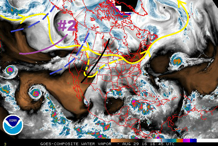
Between Event #1 and Event #2, the upper-ridge will win out, keeping the state mostly dry during those two days. A few showers/thunderstorms will still be able to develop, mainly over/near the mountains, working off of residual moisture and daytime heating. Otherwise, mostly sunny skies and generally dry conditions are expected. Event #2 refers to the next upper-level trough in the roller coaster sequence, marked by the purple line and “#2” in the water vapor image. The upper trough will be hanging around the west coast through the week and into the weekend, finally sliding across the Rockies on Monday and Tuesday (9/5 – 9/6). At this time, it appears that Gulf moisture will be transported into eastern Colorado ahead of the trough passage, setting the stage for showers/thunderstorms capable of heavy rainfall. Upslope flow in the low-levels, combined with favorable dynamics aloft, will require close watching of this event, especially for the Front Range/Southeast Mountains and adjacent lower elevations.
After Event #2, stronger ridging is expected to build across the region, bringing a much drier second half of the period. Isolated mountain showers/weak thunderstorms more capable of gusty winds than rain will be the norm of any activity, while the majority of the state dries out and warms up. We’ll keep watching this time frame for any smaller scale disturbances that may upset the dry period. Stay tuned to Thursday’s FTO.
Event #1: Tuesday (08-30-2016) through Friday (09-02-2016)
Elevated Flood Threat as Moisture Remains Through Transition
Event #1 is a blend of a weakening/exiting upper-level low and the return of southwest flow aloft. Plenty of moisture will be retained across Colorado, keeping generally unsettled weather in the forecast, but not for the same areas each day. With the transitioning upper-level pattern, different areas of the state will be favored on different days – so be sure and check back with the daily FTB forecasts.

Event #2: Monday (09-05-2016) and Tuesday (09-06-2016)
Elevated Flood Threat as Upper-Level Trough Passes through the Rockies
The upper-level trough will begin shifting eastward late in the weekend, bringing its broad-scale support for showers/thunderstorms to Colorado for Monday and Tuesday. Meanwhile, east-southeasterly low-level flow will transport Gulf moisture into eastern Colorado, providing fuel for heavy rainfall. As stated above, upslope flow combined with favorable dynamics aloft will require close watching of this event. Stay tuned.