Issue Date: Thursday, September 1st, 2016
Issue Time: 2:55PM MDT
Valid Dates: September 2 – September 16

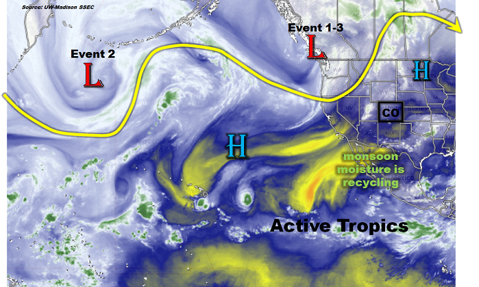
With today being the first day of meteorological fall, it is interesting to wonder whether the recent pattern of quite active and wet weather will persist. After all, the transition from August to September marks a generally stark downturn in precipitation for many lower elevation locations. As the North Pacific water vapor image shows, below, it does not appear that climatology will serve as a useful forecast during this Flood Threat Outlook (FTO). Instead, an active pattern is seen, as can be deduced by the waviness of the steering winds. In general, the more wavy the jet stream, the more it is capable of developing low and high pressure system capable of providing impactful sensible weather. Of particular interest for us is the large-scale low-pressure trough centered off the coast of British Columbia, draping from northern California northward through the Gulf of Alaska. This feature will be very slow to move and will serve as a focal point of all three Events identified for this FTO. Also of interest is the secondary low-pressure system much farther westward in the Pacific Ocean. A disturbance originating from this feature will eject and join the eastern trough in accentuating the active weather chances during Event #2.
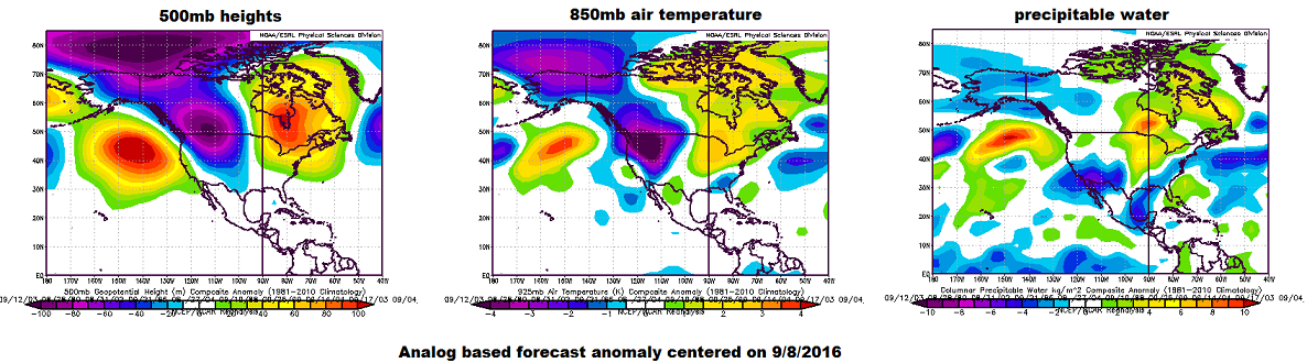
The water vapor image is a useful diagnosis tool but unfortunately has limited forecasting value. The next set of maps, centered on September 8 ( a 7 day forecast), show an analog-based approach at forecasting anomalous weather patterns based on dynamical weather models. This method uses the forecast flow and then matches it with past flows, from which we can deduce other variables such as temperature and precipitable water. The left map below shows that the trough identified in the water vapor image is actually forecasted to persist a whole week (and even farther out, though we do not show those maps). In association with this pattern, the right two maps show that on average, this kind of pattern is associated with much below normal temperatures over the Pacific Northwest and Great Basin and below normal precipitable water over the southwest United States. Thus, even though the trough will originally have some moisture to work with, causing heavy rainfall threats #1 and #2, it will eventually bring in drier air from the subtropical Pacific (which is a nearly constant storage of such dry air). Interestingly, the cold nature of the trough suggests that the first widespread accumulating snow (though probably nothing to write home about) could occur in the Central and Northern Mountains.
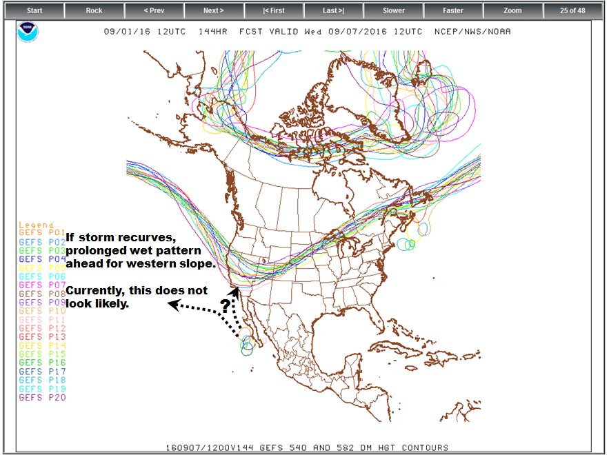
Of course, if everything was as straightforward as the analog maps above, our job would be easy. Unfortunately, it is not. A large wrinkle in the weather after Event #2 is what happens with the state of the eastern tropical Pacific. Almost all guidance is unanimous in developing a weak to moderate tropical cyclone that will move north-northwestward along the Mexican coastline. The problem, as related to Colorado’s weather, is whether or not this feature is absorbed in the large-scale trough or not. Such recurvature is fairly rare in the eastern Pacific, and current guidance shows that only about 10% chance of it recurving. If it tropical cyclone does not recurve and goes out to see, there will be little chance of active weather for Colorado. If it does recurve, or even gets close enough so that its moisture can be tapped, then there is a completely different story with a high potential for flood-worthy rainfall at least over the western slope. As previously stated, our current stand is the odds are against recurving and thus we have identified Event #3 as a No Apparent Flood Threat at this time. However, this is certainly one of the more interesting hit-or-miss type scenarios that we have seen this entire season. So, stay tuned!
Below we describe the details of the three Events identified during this Flood Threat Outlook.
Event #1: Friday (9/2) through Saturday (8/26)
An Elevated Flood Threat will focus on the western slope with some spillover possible over the Continental Divide
Enough moisture will exist over the southwest US to promote two days of scattered to widespread thunderstorm activity over the western slope. The favored region will be the San Juans due to its proximity to the moisture source. However, heavy rainfall will be possible even as far north as the southern part of the Northern Mountains (just north of I-70). Hourly rainfall rates up to 1.0 inch per hour will be capable of causing debris slides and mud flows. Isolated flash flooding will also be possible though no widespread riverine flooding is expected. By Saturday, some of the moisture and dynamics will spill over the Continental Divide and affect eastern Colorado, mainly Palmer Ridge southward. Short heavy rainfall will be possible, leading to isolated flash flooding, field and roadway flooding. Weather conditions will quite down on Sunday. Given the cool upper-level temperatures found with this system, the snow level could drop as low as 11,500 feet in the north to 12,500 feet in the south. Accumulating snows could occur during the late evening hours before precipitation winds down each day.

Event #2: Tuesday (9/6) through Wednesday (9/7)
An Elevated Flood Threat will again focus on the western slope
After a break of several days where most of the residual moisture will be used up, a smaller surge of moisture is expected from New Mexico. This will favor a heavy rainfall producing thunderstorms mainly over southern Colorado on Tuesday and Wednesday. Just like Event #1, the main threat will be short-duration (1 hour or less) rain rates up to 1.5 inches per hour east of the Continental Divide and about 1 inch per hour to the west. This will be capable of causing debris slides, mud flows and flash flooding. Wet antecedent conditions will accentuate the threat of landslides over the higher terrain.
Event #3: Thursday (9/8) – Saturday (9/10)
No Apparent Flood Threat, though everything hinges on the fate of an east Pacific tropical system
This is where things get interesting, though uncertain. If the tropical cyclone that is forecasted to be south of Baja California recurves or has enough moist outflow to be tapped by the large-scale trough, a 1-3 day spurt of very wet weather will be likely across the western slope (focused on the San Juans). This would result in up to 4 inches, or more, or rainfall over a multi-day period. However, currently the odds of this are too slim to assign it an elevated flood threat. Certainly stay tuned to the Monday FTO for a fresh look at the latest guidance.