FTO 09-22-2016: Mainly Dry, Warm End To September

Issue Date: Thursday, September 22nd, 2016
Issue Time: 1:30PM MDT
Valid Dates: September 23rd trough October 7th

threat_timeline

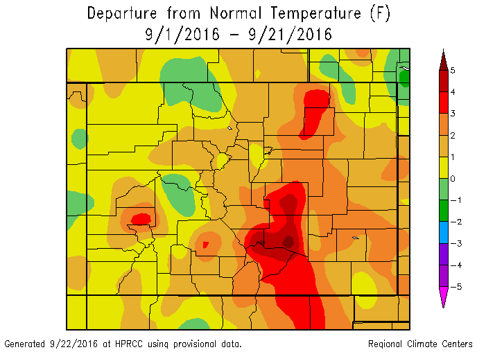
It has been a warm September for Colorado, with average temperatures running up to 4 F above normal east of the Continental Divide (see map below). Accompanying the warmth has been a lack of rainfall basically statewide. Fortunately, September is not a particularly important month from the standpoint of water supply since average precipitation in valley locations begins to decrease from its summer peak. Meanwhile, higher elevation precipitation does not really begin in earnest until October as the jet stream intensifies and moves south, providing a steady stream of moist Pacific air that hits our mountain ranges and condenses.

sep_anomaly

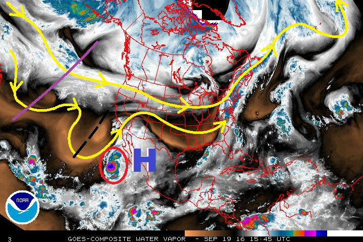
As the water vapor image shows, below, apart from an early event that will yield light to moderate rainfall amounts mainly over the higher terrain west of the Divide, the rest of September is likely to follow what we have seen up to now: dry and warm. This will be courtesy of a sprawling upper-level ridge that is seen on the water vapor image.

wv_markup

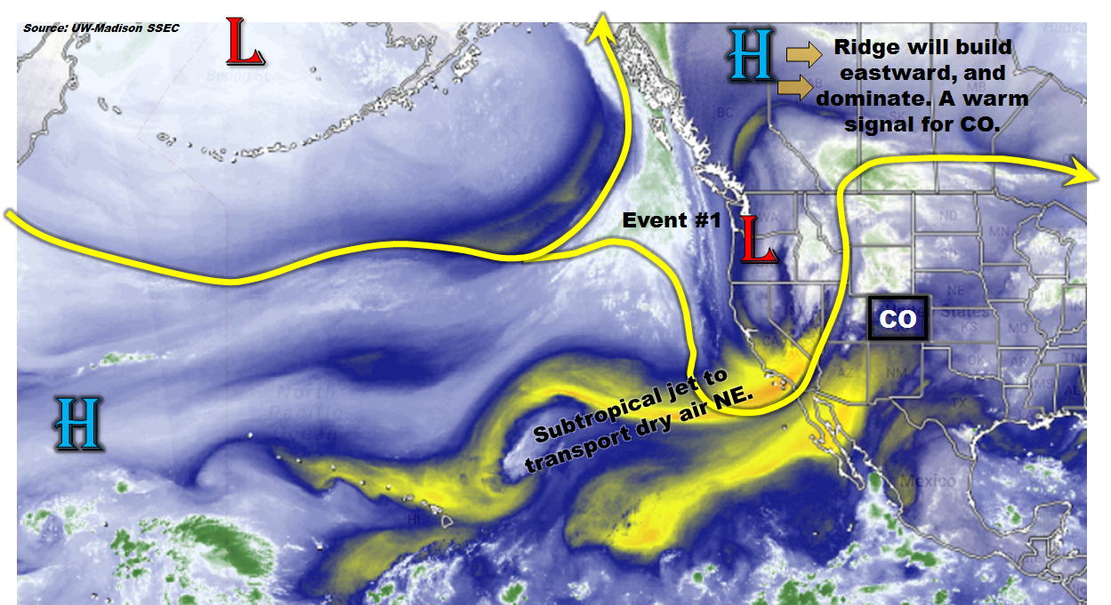
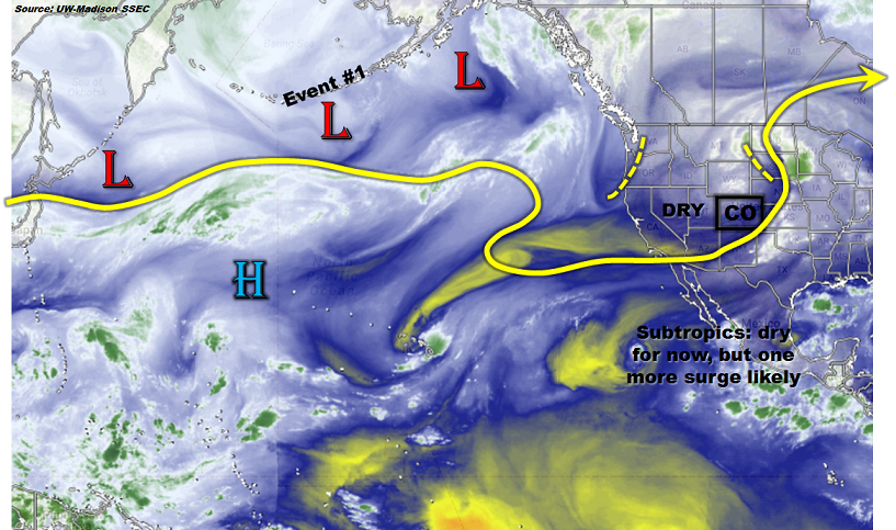
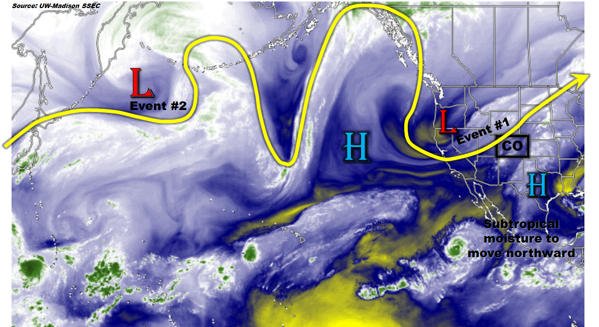
The high-pressure feature will move eastward and intensify, the net effect being a clockwise circulation that will promote southerly warm air to impinge on Colorado. In concert with this, as the current upper-level trough moves eastward, it will transport dry (perhaps very dry) air from the subtropical eastern Pacific Ocean. This will set the stage for a multi-day period of very warm temperatures, up to 15F above normal accompanied by relatively low moisture content later next week. Some readers may have already made the connection: there is likely to be an elevated wildfire threat. The most likely areas to experience the anomalous warmth and heat will be east of the Continental Divide. However, the entire state is expected to average normal to above normal, temperature wise, over the 15-day period covered by this Flood Threat Outlook. One minor exception to this rule could be late next week (9/30-10/2) when a new upper-level trough will likely enter the west coast. There are some indications that a moderate amount of subtropical moisture could be drawn into this trough, resulting in a round of showers and maybe a few storms west of the Divide (Event #2). However, at this time, it will be surprising if this can generate widespread rainfall exceeding 0.5 inches. Thus, both Events are designated as No Apparent Flood Threat.

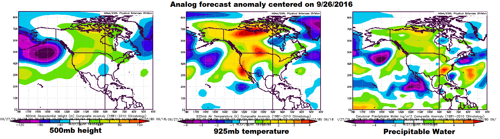
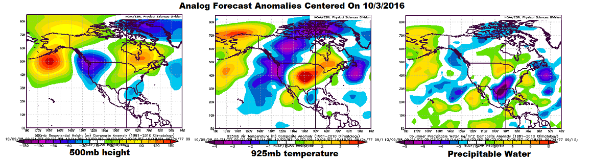
Overall, today’s analog anomalies centered on October 3rd provide an excellent summary of what we can expect over the next 15 days. Note the 500-mb height ridge position by that time moves into eastern North America, while a weak semi-stationary trough holds firm over the Pacific northwest. On the low-level temperature map (we are using the 925-mb level), note the very strong warm anomalies over the Great Plains, including eastern Colorado.

8-14day_analog_3panel

Below we describe the details of the two Events.

Event #1: Friday (9/23) and Saturday (9/24)

No Apparent Flood Threat as trough moves across Colorado

The large-scale trough that is currently affecting western Colorado will move across the state on Friday and Saturday. Despite the seemingly high moisture levels, most of this moisture is being held well above the boundary layer. Nonetheless, several rounds of showers and perhaps a weak thunderstorm will race across the state on Friday, mainly limited to the higher terrain. Up to 0.75 inches of rainfall will be possible over isolated locations, but flooding is not expected as this precipitation will be spread out over several hours. Rainfall amounts will decrease further on Saturday with up to 0.5 inches possible over isolated locations of northern and eastern Colorado.

As the trough moves overhead by late Friday, it will be accompanied by a 48-hour period of much cooler weather with snow levels coming down to 9,500 feet. However, accumulating snow will be hit-or-miss and only a few inches, at most, are expected in any given location. The one exception to this will be the San Juans where perhaps up to 6 inches could fall. Overall, this event is likely to be known more for its winds, which could gust up to 70 mph over the higher terrain, than its precipitation.


Legend

Event #2: Saturday (10/1)

No Apparent Flood Threat as another trough approaches Colorado

After Event #1, dry and very warm weather will return across Colorado (especially eastern areas). The next weather feature will be another large-scale trough (identified as Event #2 in Brad’s previous post) that is forecast to enter the west coast late next week. At this time, it does not appear that this trough will have enough moisture to deliver much rainfall across the state. Instead, it could be another wind event much like Event #1. The only caveat is the potential entrainment of subtropical air courtesy of a recurving tropical storm. Many things will have to come together for this to happen, and the most probable outcome at this time appears to be a light rainfall event (less than 0.5 inches; hence no precipitation map). Worst-case scenario, this could turn into a low-end flood threat for southwest Colorado should enough subtropical moisture get involved. Stay tuned to Monday’s updated Outlook.

FTO 09-19-2016: Elevated Flood Threat to Start, Quiet to Finish

Issue Date: 9/19/2016
Issue Time: 1:20 PM

threat_timeline_20160919

The 2016 season is winding down as we transition from summer to fall, but Mother Nature isn’t ready to wind down the flood threats just yet. Event #1 has been given the “Elevated Threat” designation, thanks to the combination of an upper-level trough and an upper-level high situated over northern Mexico pulling some mid-level, subtropical moisture associated with Hurricane Paine (red circle) over the region. The initial shortwave (black dashed lines) will prime the atmosphere with the push of moisture, while the main trough (purple line) follows closely and provides broad-scale support for showers/thunderstorms. The best support, and heaviest rains, will remain over Utah, Wyoming, Arizona, and Idaho, but a few stronger showers/storms capable of heavy rainfall are possible over western Colorado.

East of the Continental Divide, low-level dry air and minimal upper-level support will rule the forecast, resulting in only isolated showers/thunderstorms during the afternoon and evening hours for Tuesday through Thursday. By Friday, a surface low (and associated cool frontal boundary) will move across the area, bringing a more active day to eastern Colorado, mainly the far eastern plains. A few stronger thunderstorms are possible, so this will be monitored closely in the appropriate FTB’s. The upper-level trough associated with Event #1 will then eject to the northeast of the area on Friday evening, resulting in much cooler temperatures for the end of the week and into the weekend. Snow levels on Friday will drop to around 9000 feet, and it will be hard to escape the thoughts that Winter is just around the corner.

wv_20160919

After Event #1, westerly flow aloft will return to the region as high pressure settles over northern Mexico and the Desert Southwest once again. This will result in a drier period through the next mid-week, with high temperatures gradually warming to seasonal marks. Ensemble forecasts are indicating a second event late next week (Sept. 28-30) as an upper-level trough pushes into the western US. Moisture return ahead of this trough doesn’t appear to be too great, so “No Apparent Threat” will be the designation at this time. We will continue to monitor this event, and will provide an update in Thursday’s FTO.

Event #1: Tuesday (09-20-2016) through Friday (09-23-2016)

Elevated Flood Threat West of the Continental Divide

The combination of an upper-level trough, upper-level high, and the remnants of Hurricane Paine will result in a multi-day wet period for western Colorado. The best support for heavy rainfall and potential flooding issues will remain in neighboring states, but there remains potential for a few stronger showers/storms across Western Colorado to produce periods of heavy rainfall. As the event wears on, cooler temperatures will drop snow levels below 10,000 feet, perhaps as low as 8,000 feet in some locations. East of the Continental Divide, isolated showers/storms will be about all Mother Nature can muster, with a conditional threat for stronger storms on Friday across the far eastern plains. The entire event will be monitored closely in the daily FTB, so please stay tuned.

Legend

Event #2: Wednesday (09-28-2016) through Friday (09-30-2016)

No Apparent Flood Threat as Moisture Returns Appears Lackluster

Ensemble forecasts are indicating the return of an upper-level trough to the western US late next week, providing broad-scale support for showers and perhaps a few thunderstorms. The biggest question mark is just how much moisture will be available to this potential event. No precipitation map will be drawn due to the inherent uncertainty in this type of event, so stay tuned to Thursday’s FTO for an updated look at this time frame.

FTO 09-15-2016: Mainly Dry and Very Warm Early, Then A (Final?) Monsoon Surge

Issue Date: Thursday, September 15th, 2016
Issue Time: 1:00PM MDT
Valid Dates: September 16 – September 30

Despite the presence of a broad-scale upper-level trough over the western US (see water vapor image below), there is simply not enough moisture for rainfall. Precipitable water (PW) values across Colorado are in the 0.4 to 0.6 inch range and even lower values are found upstream to the southwest. Thus, while there will be some showers and maybe even a weak thunderstorm storm as this trough moves eastward, most everyone will stay dry. The other one feature to note from the water vapor image is that the monsoon moisture source region is also quite dry.

The trough will move through over the next 72 hours, allowing for a high-pressure ridge east of the Rockies favoring mainly dry and very warm southerly flow across Colorado. Expect several days of above to well above average temperatures mainly east of the Continental Divide. High temperatures could exceed 90F in the lower elevations of the valleys of the South Platte and Arkansas rivers.

wv_markup

Looking further starting middle of next week and beyond, the ridge is expected to cede its ground to a weak to moderate trough that is currently positioned south of the Aleutian Islands (see water vapor image). At the same time, a moderate push of monsoonal moisture will boost PW values to above 0.75 inches over the western slope. Together, this will provide us with precipitation Event #1, during which no apparent flood threat is foreseen.

Looking further still, deterministic forecasts begin to lose value past 7 days out. Thus, we turn to more probabilistic methods. Below, we show the forecasted anomalies centered on 9/26 using the analog method. The main feature of note is the moderate to strong trough over the Gulf of Alaska. This type of circulation favors very warm temperature anomalies over most of Canada and the Pacific Northwest as southwesterly flow transports relatively warm Pacific air over the continent. However, for Colorado, this type of pattern provides little predictive skill as we note that low-level temperature and PW anomalies (see right two maps below) show only weak values across our state. Nonetheless, looking at individual forecasts from many long-range ensembles, there is a loose consensus that a strong fall cool front will approach the state by Monday 9/26. Despite the fact that this is 10 days out, there is enough of an indication this this is realistic to warrant a label of Event #2. This event will not bring a flood threat but could provide widespread cool weather rainfall (and higher elevation snowfall) east of the Continental Divide. As always, stay tuned to next Monday’s FTO as new guidance is taken into account.

8-14day_analog_3panelBelow, we discuss each event in more detail.

Event #1: Wednesday (9/21) and Thursday (9/22)

No Apparent Flood Threat as monsoon surge combines with trough passage

After a string of warm days, a large-scale trough will approach Colorado from the northwest. At the same time, a surge of moist monsoonal flow will develop. This combination will create a window of opportunity for showers and a few thunderstorms mainly along the western slope. Up to 1 inch of rain could fall along favored higher-terrain areas of the San Juan, Central and Northern Mountains. Spillover east of the Divide is not looking very favorable right now. However, a second area of rainfall could be found in far northeastern Colorado in association with the cool front passage. Overall, flooding is not expected with this event.


Legend

Event #2: Monday (9/26) and Tuesday (9/27)

No Apparent Flood Threat as strong cold front could provide for a short period of interesting weather

There has been consistency in longer-range guidance in showing a quick but strong cold front coming south out of Canada. This could spawn a 24-36 hour upslope circulation in southern Colorado. Widespread light to moderate rainfall up to 1.0 inches would result with such an event. Mountain snows would also be likely in the Sangre de Cristo and Wet Mountains. Guidance suggests this would be a relatively brief event quickly being replaced by warm downsloping flow after its passage. At this time, we are not providing a precipitation map due to low confidence but this is certainly something to keep an eye on.

FTO 09-12-2016: Active Pattern Ahead as Dynamics And Moisture Return To Colorado

Issue Date: Monday, September 12th, 2016
Issue Time: 3:00PM MDT
Valid Dates: September 13th through September 27th

threat_timeline

As alluded to in last Thurday’s Flood Threat Outlook and shown in the water vapor image, below, a low-pressure system and associated large-scale trough is located over northern California. Despite the seemingly favorable dynamics of this kind of setup, initially (today) rain drops will be few and far between over Colorado. However, as the boundary layer flow turns southeasterly in association with a surface low-pressure expected to form north of CO, higher moisture will slowly stream into Colorado. This will setup Event #1 on Wednesday and Thursday. Thereafter, a ridge off the west coast of North American will establish dominance over western Canada. This will promote seasonably mild and drier conditions statewide for a period of 3-5 days. By the week of Monday, 9/19, another large-scale trough currently found off the southwest side of the far western Aleutian islands will propagate across the eastern North Pacific and will likely impact Colorado. However, despite the once-again generally favorable dynamics from the proximity to the trough, the heavy rainfall threat is not certain. One uncertainty is the degree of moisture return, which will tend to limit the flood threat to southern and eastern areas. Another somewhat related uncertainty is the potential for a deep subtropical connection, which would promote a chance of heavy rain across relatively large portions of the western slope. Currently, the moisture return for Event #2 looks marginal; hence, we identify this as No Apparent Flood Threat. However, stay tuned to the next FTO for updates. After Event #2, guidance rapidly diverges with some scenarios showing a wet Colorado with prolonged subtropical moisture return from the south/southwest. Others paint a much drier scenario with seasonable temperatures. This disparity in guidance is likely due to the expected development of a cut-off low across the southwest, which is notorious for erratic movements. Again, check the next FTO for an updated assessment of this feature.

wv_markup

Below we describe the details of the two Events.

Event #1: Wednesday (9/14) and Thursday (9/15)

An Elevated Flood Threat for eastern areas

This is Event #2 from last Thursday’s FTO and certainly a rapidly evolving one. The latest guidance suggests the possibility of a cool front to stall out across eastern Colorado. At a minimum, daily rounds of scattered showers and thunderstorms will be found across and south of the front, mainly closer to the Kansas border. On the other hand, a focused stalled out front could cause multiple rounds of storm activity on Wednesday and Thursday. At this point, up to 2.25 inches of rainfall will be possible over a 48-hour period across eastern Colorado with up to 0.75 inches farther south and west in the foothills. There is a chance that this event may need to be upgraded to a High flood threat status, depending on whether there is enough consensus that thunderstorm training (or redevelopment over the areas). Stay tuned to upcoming FTBs for the latest updates.


Legend

Event #2: Monday (9/19) and Tuesday (9/20)

No Apparent Flood Threat but this event could be upgraded

The active weather conditions will pause briefly as drier air follows the passage of Event #1. By Sunday 9/18, height falls associated with the next large-scale trough will being across the southwest United States. While some rainfall may occur Sunday, it is likely that the atmosphere will be too dry at that point (in fact, similar to today’s weather situation, 9/12). However, by Monday, southerly flow will usher in higher low-level moisture and adequate instability will develop to promote scattered to widespread thunderstorms. The most favored areas for heavy rain will likely be across southern areas. A few rounds of thunderstorm activity could produce up to 1.5 inches of rain over a 48-hour period. At this point, we are leaving this without a flood threat as rainfall amounts should remain below flood guidance. However, it is certainly possible that this event may need to be upgraded. This could occur if deep tropical moisture becomes involved in the return flow. Another potential scenario is the recurving of a tropical cyclone, as we recently witnessed with Newton. Due to the low confidence in such long-lead forecasts in the tropics, No Apparent Flood Threat is seen at this time.

Legend