Issue Date: Thursday, September 15th, 2016
Issue Time: 1:00PM MDT
Valid Dates: September 16 – September 30
Despite the presence of a broad-scale upper-level trough over the western US (see water vapor image below), there is simply not enough moisture for rainfall. Precipitable water (PW) values across Colorado are in the 0.4 to 0.6 inch range and even lower values are found upstream to the southwest. Thus, while there will be some showers and maybe even a weak thunderstorm storm as this trough moves eastward, most everyone will stay dry. The other one feature to note from the water vapor image is that the monsoon moisture source region is also quite dry.
The trough will move through over the next 72 hours, allowing for a high-pressure ridge east of the Rockies favoring mainly dry and very warm southerly flow across Colorado. Expect several days of above to well above average temperatures mainly east of the Continental Divide. High temperatures could exceed 90F in the lower elevations of the valleys of the South Platte and Arkansas rivers.
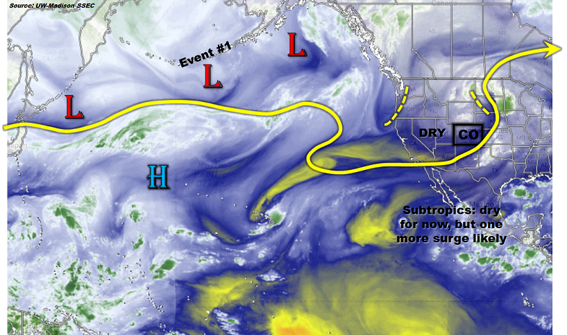
Looking further starting middle of next week and beyond, the ridge is expected to cede its ground to a weak to moderate trough that is currently positioned south of the Aleutian Islands (see water vapor image). At the same time, a moderate push of monsoonal moisture will boost PW values to above 0.75 inches over the western slope. Together, this will provide us with precipitation Event #1, during which no apparent flood threat is foreseen.
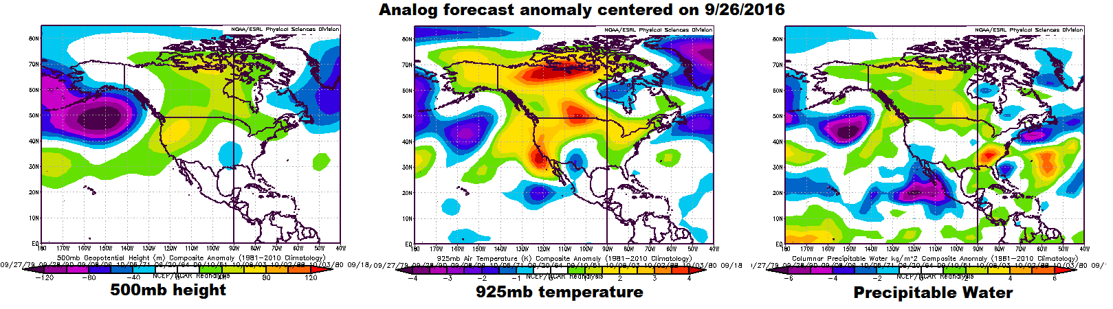
Looking further still, deterministic forecasts begin to lose value past 7 days out. Thus, we turn to more probabilistic methods. Below, we show the forecasted anomalies centered on 9/26 using the analog method. The main feature of note is the moderate to strong trough over the Gulf of Alaska. This type of circulation favors very warm temperature anomalies over most of Canada and the Pacific Northwest as southwesterly flow transports relatively warm Pacific air over the continent. However, for Colorado, this type of pattern provides little predictive skill as we note that low-level temperature and PW anomalies (see right two maps below) show only weak values across our state. Nonetheless, looking at individual forecasts from many long-range ensembles, there is a loose consensus that a strong fall cool front will approach the state by Monday 9/26. Despite the fact that this is 10 days out, there is enough of an indication this this is realistic to warrant a label of Event #2. This event will not bring a flood threat but could provide widespread cool weather rainfall (and higher elevation snowfall) east of the Continental Divide. As always, stay tuned to next Monday’s FTO as new guidance is taken into account.
 Below, we discuss each event in more detail.
Event #1: Wednesday (9/21) and Thursday (9/22)
No Apparent Flood Threat as monsoon surge combines with trough passage
After a string of warm days, a large-scale trough will approach Colorado from the northwest. At the same time, a surge of moist monsoonal flow will develop. This combination will create a window of opportunity for showers and a few thunderstorms mainly along the western slope. Up to 1 inch of rain could fall along favored higher-terrain areas of the San Juan, Central and Northern Mountains. Spillover east of the Divide is not looking very favorable right now. However, a second area of rainfall could be found in far northeastern Colorado in association with the cool front passage. Overall, flooding is not expected with this event.

Event #2: Monday (9/26) and Tuesday (9/27)
No Apparent Flood Threat as strong cold front could provide for a short period of interesting weather
There has been consistency in longer-range guidance in showing a quick but strong cold front coming south out of Canada. This could spawn a 24-36 hour upslope circulation in southern Colorado. Widespread light to moderate rainfall up to 1.0 inches would result with such an event. Mountain snows would also be likely in the Sangre de Cristo and Wet Mountains. Guidance suggests this would be a relatively brief event quickly being replaced by warm downsloping flow after its passage. At this time, we are not providing a precipitation map due to low confidence but this is certainly something to keep an eye on.