Issue Date: 9/19/2016
Issue Time: 1:20 PM

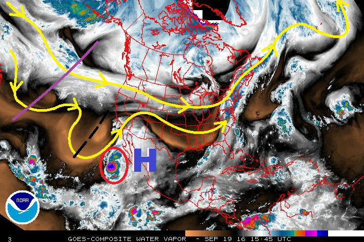
The 2016 season is winding down as we transition from summer to fall, but Mother Nature isn’t ready to wind down the flood threats just yet. Event #1 has been given the “Elevated Threat” designation, thanks to the combination of an upper-level trough and an upper-level high situated over northern Mexico pulling some mid-level, subtropical moisture associated with Hurricane Paine (red circle) over the region. The initial shortwave (black dashed lines) will prime the atmosphere with the push of moisture, while the main trough (purple line) follows closely and provides broad-scale support for showers/thunderstorms. The best support, and heaviest rains, will remain over Utah, Wyoming, Arizona, and Idaho, but a few stronger showers/storms capable of heavy rainfall are possible over western Colorado.
East of the Continental Divide, low-level dry air and minimal upper-level support will rule the forecast, resulting in only isolated showers/thunderstorms during the afternoon and evening hours for Tuesday through Thursday. By Friday, a surface low (and associated cool frontal boundary) will move across the area, bringing a more active day to eastern Colorado, mainly the far eastern plains. A few stronger thunderstorms are possible, so this will be monitored closely in the appropriate FTB’s. The upper-level trough associated with Event #1 will then eject to the northeast of the area on Friday evening, resulting in much cooler temperatures for the end of the week and into the weekend. Snow levels on Friday will drop to around 9000 feet, and it will be hard to escape the thoughts that Winter is just around the corner.
After Event #1, westerly flow aloft will return to the region as high pressure settles over northern Mexico and the Desert Southwest once again. This will result in a drier period through the next mid-week, with high temperatures gradually warming to seasonal marks. Ensemble forecasts are indicating a second event late next week (Sept. 28-30) as an upper-level trough pushes into the western US. Moisture return ahead of this trough doesn’t appear to be too great, so “No Apparent Threat” will be the designation at this time. We will continue to monitor this event, and will provide an update in Thursday’s FTO.
Event #1: Tuesday (09-20-2016) through Friday (09-23-2016)
Elevated Flood Threat West of the Continental Divide
The combination of an upper-level trough, upper-level high, and the remnants of Hurricane Paine will result in a multi-day wet period for western Colorado. The best support for heavy rainfall and potential flooding issues will remain in neighboring states, but there remains potential for a few stronger showers/storms across Western Colorado to produce periods of heavy rainfall. As the event wears on, cooler temperatures will drop snow levels below 10,000 feet, perhaps as low as 8,000 feet in some locations. East of the Continental Divide, isolated showers/storms will be about all Mother Nature can muster, with a conditional threat for stronger storms on Friday across the far eastern plains. The entire event will be monitored closely in the daily FTB, so please stay tuned.

Event #2: Wednesday (09-28-2016) through Friday (09-30-2016)
No Apparent Flood Threat as Moisture Returns Appears Lackluster
Ensemble forecasts are indicating the return of an upper-level trough to the western US late next week, providing broad-scale support for showers and perhaps a few thunderstorms. The biggest question mark is just how much moisture will be available to this potential event. No precipitation map will be drawn due to the inherent uncertainty in this type of event, so stay tuned to Thursday’s FTO for an updated look at this time frame.