Issue Date: Monday, September 12th, 2016
Issue Time: 3:00PM MDT
Valid Dates: September 13th through September 27th

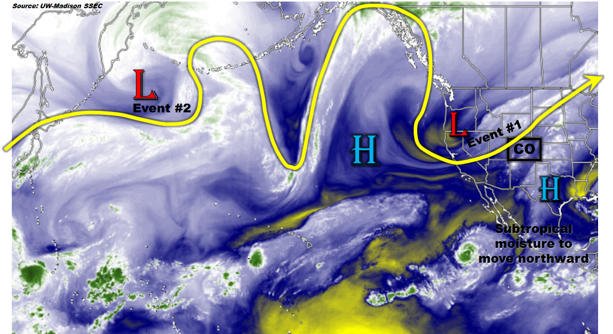
As alluded to in last Thurday’s Flood Threat Outlook and shown in the water vapor image, below, a low-pressure system and associated large-scale trough is located over northern California. Despite the seemingly favorable dynamics of this kind of setup, initially (today) rain drops will be few and far between over Colorado. However, as the boundary layer flow turns southeasterly in association with a surface low-pressure expected to form north of CO, higher moisture will slowly stream into Colorado. This will setup Event #1 on Wednesday and Thursday. Thereafter, a ridge off the west coast of North American will establish dominance over western Canada. This will promote seasonably mild and drier conditions statewide for a period of 3-5 days. By the week of Monday, 9/19, another large-scale trough currently found off the southwest side of the far western Aleutian islands will propagate across the eastern North Pacific and will likely impact Colorado. However, despite the once-again generally favorable dynamics from the proximity to the trough, the heavy rainfall threat is not certain. One uncertainty is the degree of moisture return, which will tend to limit the flood threat to southern and eastern areas. Another somewhat related uncertainty is the potential for a deep subtropical connection, which would promote a chance of heavy rain across relatively large portions of the western slope. Currently, the moisture return for Event #2 looks marginal; hence, we identify this as No Apparent Flood Threat. However, stay tuned to the next FTO for updates. After Event #2, guidance rapidly diverges with some scenarios showing a wet Colorado with prolonged subtropical moisture return from the south/southwest. Others paint a much drier scenario with seasonable temperatures. This disparity in guidance is likely due to the expected development of a cut-off low across the southwest, which is notorious for erratic movements. Again, check the next FTO for an updated assessment of this feature.
Below we describe the details of the two Events.
Event #1: Wednesday (9/14) and Thursday (9/15)
An Elevated Flood Threat for eastern areas
This is Event #2 from last Thursday’s FTO and certainly a rapidly evolving one. The latest guidance suggests the possibility of a cool front to stall out across eastern Colorado. At a minimum, daily rounds of scattered showers and thunderstorms will be found across and south of the front, mainly closer to the Kansas border. On the other hand, a focused stalled out front could cause multiple rounds of storm activity on Wednesday and Thursday. At this point, up to 2.25 inches of rainfall will be possible over a 48-hour period across eastern Colorado with up to 0.75 inches farther south and west in the foothills. There is a chance that this event may need to be upgraded to a High flood threat status, depending on whether there is enough consensus that thunderstorm training (or redevelopment over the areas). Stay tuned to upcoming FTBs for the latest updates.

Event #2: Monday (9/19) and Tuesday (9/20)
No Apparent Flood Threat but this event could be upgraded
The active weather conditions will pause briefly as drier air follows the passage of Event #1. By Sunday 9/18, height falls associated with the next large-scale trough will being across the southwest United States. While some rainfall may occur Sunday, it is likely that the atmosphere will be too dry at that point (in fact, similar to today’s weather situation, 9/12). However, by Monday, southerly flow will usher in higher low-level moisture and adequate instability will develop to promote scattered to widespread thunderstorms. The most favored areas for heavy rain will likely be across southern areas. A few rounds of thunderstorm activity could produce up to 1.5 inches of rain over a 48-hour period. At this point, we are leaving this without a flood threat as rainfall amounts should remain below flood guidance. However, it is certainly possible that this event may need to be upgraded. This could occur if deep tropical moisture becomes involved in the return flow. Another potential scenario is the recurving of a tropical cyclone, as we recently witnessed with Newton. Due to the low confidence in such long-lead forecasts in the tropics, No Apparent Flood Threat is seen at this time.