FTO 05-04-2017: Typical Spring Pattern to Bring Rain (and Snow), with Warm Days in Between

Issue Date: May 4th, 2017
Issue Time: 2:10PM MDT
Valid Dates: May 5th – May 19th

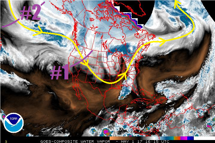
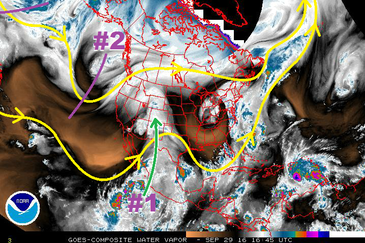
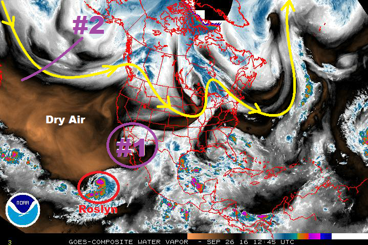
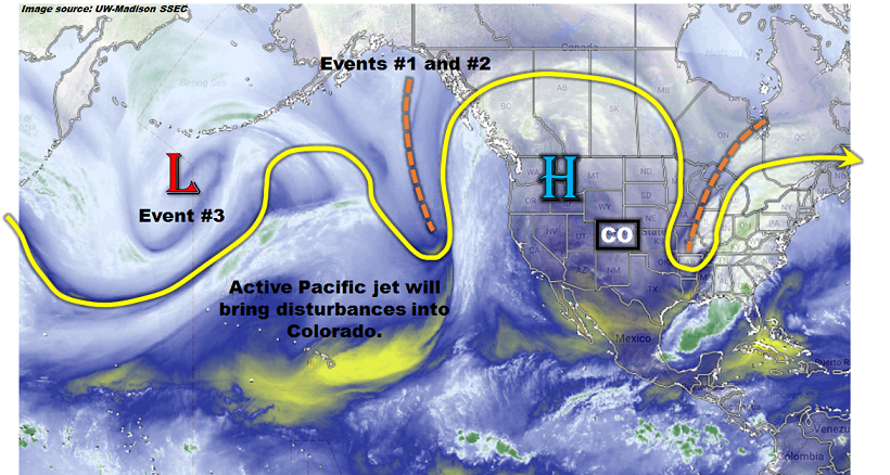
This afternoon’s North Pacific water vapor image, below, shows a generally active atmospheric pattern. A strong and elongated jet stream is stretched from east of Japan nearly all the way to North America’s west coast. Within this jet stream are several embedded disturbances, marked as Event 1/2 and Event 3. These will provide the mechanisms for disturbed weather across Colorado over the next 15 days. One additional important feature to note is a sprawling high pressure across the western United States. This feature will be hard to displace over the next two weeks and will provide a quick rebound to warm/hot temperatures after the passage of precipitation events.

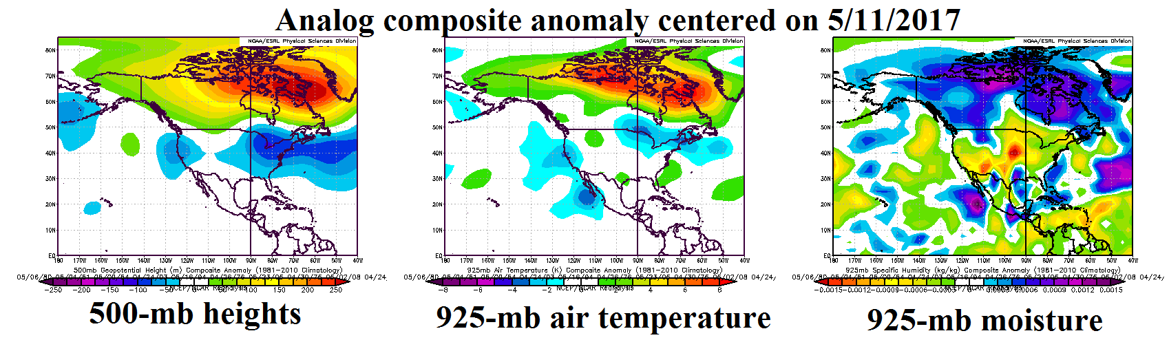
The water vapor image acts as a good measure of current conditions. To investigate how this pattern will evolve, we turn to atmospheric weather models for guidance. One guidance tool that we like to use is the Climate Prediction Center’s analog method that essentially finds historical snapshots of conditions that resemble the current model predictions. The image below shows composite anomalies of 500-mb heights, 925-mb air temperature and 925-mb moisture content (specific humidity) centered 8 days from now. The 500-mb anomalies show rather weak features around Colorado with a much more pronounced signal coming in the form of a strong ridge across most of Canada. In fact, models suggest that this ridge will attempt to bulge into the Central Plains surrounded by two low-pressure anomalies in the far western US as well as the eastern US. Both of these disturbances are too far to have direct impact on our weather. Nonetheless, we do expect at least one significant disturbance to penetrate the ridge and provide a multi-day period of inclement weather (Event 1 and 2). After this disturbance passes Colorado, a moderate strength ridge will re-establish itself providing several days of average to above average temperatures. Thereafter, there are indications that the western US low pressure anomaly will progress far enough east to affect Colorado with precipitation chances by late in the forecast period.

Event #1: Saturday (5/6) and Sunday (5/7)

No Apparent Flood Threat

An initial disturbance associated with the large-scale trough off the US west coast will affect mainly the higher elevations on Saturday and Sunday. With little atmospheric instability, we expect light to moderate rain and snow showers across mainly higher elevations of the state. Precipitation amounts up to 0.4 inches will be possible over this two-day period. Isolated thunderstorms cannot be ruled out east of the Continental Divide. However, rain rates will stay below flood threat levels (0.5 inch per hour or less). With precipitation expected to remain below 0.5 inches, a precipitation map is not shown.

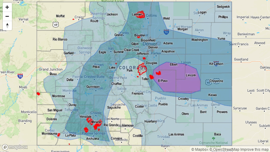
Event #2: Tuesday (5/9) through Thursday (5/11)

Elevated Flood Threat as a developing cut-off low moves across Colorado; severe weather possible in southeast Colorado

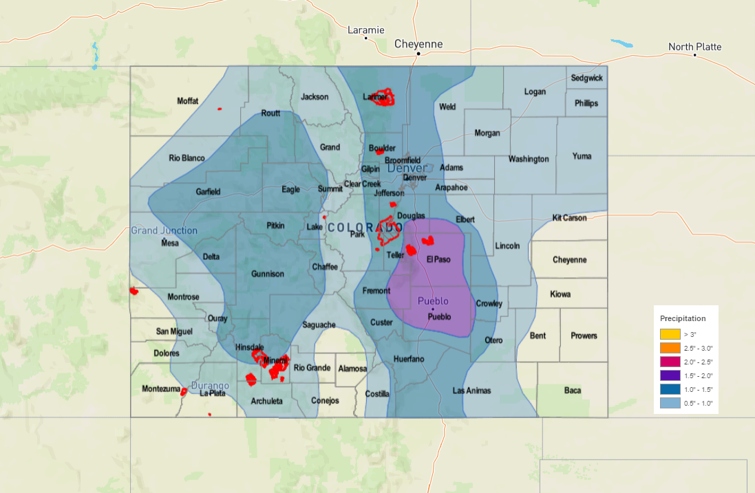
Guidance tools are in reasonably good agreement that the disturbance responsible for Event #1 will cut-off from the main jet stream, slowing its progression. However, it will continue to slowly move towards Colorado so that by Tuesday, it will begin to affect the southern portion of the state with precipitation. Enough moisture return suggests that there will be instability especially in the southern and eastern parts of the state. Thus, several rounds of showers and thunderstorms are anticipated, with maximum 1-hour rain rates up to 1.0 inch and 24-hour rainfall up to 1.5 inches in the higher elevations. As the disturbance continues to move northeastward, on Wednesday, we expect additional activity for the central and northeastern parts of the state. However, at this point, the amount of instability is in question. It appears the far eastern parts of the state will have the highest risk of flash flooding, while steadier, lighter precipitation affects most everyone else. There is disagreement is how fast this disturbance will move and it is possible that cool weather and light to moderate rain/snow showers remain through Thursday. However, the flood threat will be over by Thursday. See below for total precipitation expected with this event.

: Tuesday (5/16) through Thursday (5/18)

No Apparent Flood threat as amount of instability is uncertain

The persistent low-pressure anomaly forecast for the US west coast will move into the Great Basin and possibly affect Colorado during this time period. The amount of moisture return from the Gulf of Mexico will dictate the flood threat with this event. At this time, it does not appear like instability will be high enough for widespread heavy rainfall. Instead, light to moderate precipitation is expected, which would be good news for summer water supply. At this time, precipitation totals are expected to remain below 0.5 inches, and thus, no precipitation map is shown.

FTO 05-01-2017: Two Events, One Elevated Flood Threat

Issue Date: 5/1/2017
Issue Time: 1:07 PM

Mother Nature is greeting the return of the Flood Threat Bulletin/Flood Threat Outlook season with two events in the 10 days. The water vapor imagery below denotes the location of both of these events well. Event #1 is a fairly weak, disorganized trough that will rotate across the area tomorrow (Tuesday), with some effects lingering until early Wednesday. There isn’t much moisture available, and therefore there is no apparent flood threat associated with the event. After Event #1, high pressure ridging will take over for a short period before turning the reigns over to Event #2.

Event #2 shows up well in the water vapor image above as a trough over the Northern Pacific. This trough will continue to deepen as it advances towards the Continental US, with southerly flow ahead of it bringing subtropical moisture into region. From the base of the trough, a cutoff low is expected to develop, separating itself from the main atmospheric flow. This will cause the upper-low to linger over the southwestern US, bringing an extended period of unsettled weather to Colorado. With a setup like this, not only will there be concern for periods of heavy rain, but also severe weather across eastern Colorado. Fine details like those will be resolved in the coming days, so stay tuned to daily FTB’s and Thursday’s FTO for updated information.

Event #1: Tuesday (05-02-2017) and Wednesday (05-03-2017)

No Apparent Threat for Disorganized Trough with Limited Moisture

The disorganized trough will come through on the heels of the more impressive recent low pressure system, which will limit its ability to draw moisture into the area. The mountains will see a decent shot of snow, while the plains will see scattered-to-widespread rain showers. A couple thunderstorms cannot be ruled out, but they will lack the moisture to produce any sort of flood threat. The heaviest rain, relatively speaking, will fall across the Southeast Plains. Totals are not expected to top 0.5 inches, so no precipitation map will be drawn.

Event #2: Saturday (05-06-2017) through Thursday (05-11-2017)

Elevated Flood Threat Taking Shape

The upcoming system associated with Event #2 is one to keep an eye on. This type of setup will result in an extended period of unsettled weather, and the longer the upper-low lingers to our southwest, the more moisture that will be transported into Colorado. Those details will be resolved as we get closer to the event. Saturday/Sunday will be a nice precursor to the “main” portion of the event, as the first good batch of moisture arrives and instability develops. Monday-Tuesday-Wednesday will be the stretch with the best overlap of moisture and environmental support, and Thursday will be the final gasp of the moisture and lingering showers. Stay tuned to the FTO on Thursday more updated look at this event.

FTO 09-29-2016: Final FTO of the Season, 2 Events

Issue Date: 9/29/2016
Issue Time: 2:50 PM

threat_timeline_20160929

Well, the day is finally upon us to issue the final Flood Threat Outlook of the 2016 season. As always, it has been a pleasure to serve you and to provide these valuable products. Before jumping into the discussion of this FTO period, I wanted to take a look farther down the road and discuss how things look in the long-term. The image below is the Drought Monitor for the state of Colorado, released this morning (09-29-2016).

drought_20160927

While much of the state remains without drought, a large swath of abnormally dry conditions has taken hold across portions of Colorado, particularly for northern areas. In additional, moderate drought conditions are depicted along the Front Range/Urban Corridor, and across the Palmer Ridge region. A drought, while never a good thing, is not as alarming this time of year as compared to one developing in the spring time. This is due to the fact that, climatologically speaking, precipitation drops off sharply between August and September, and a bit more into October. If this drought were creeping up during the spring when Colorado typically sees its highest rain and snow, the cause for concern would be greater. This situation is something to keep an eye on moving forward, and will be important to monitor going into next spring, when its impacts could become more profound. Now, let’s jump back into the present time period and discuss this FTO period.

There are two events in the upcoming period, both occurring within the first 6 days. Event #1 is the continuation of an event already underway, associated with the weakening upper-level low drifting northward across the Great Basin. This upper-level low has brought a subtropical surge to western Colorado, highlighted by the green arrow in the water vapor image below. Eventually, the low will wash out in the mean flow, with the lingering moisture providing fuel for a few more days of lingering showers across the High Country and Western Slope. No flood threat is apparent with this event, as rain rates are expected to remain well below flash flood thresholds.

wv_20160929

Event #2 is depicted in the water vapor image as an upper-level trough currently positioned off the West Coast. This trough, and developing closed low, will shift into the Great Basin on Monday, bringing strong southwesterly winds aloft to the region. Concurrently, a surface low will develop, with an attendant cold front sweeping across the area. Along the front, a few storms may become strong over the High Country and Western Slope, owing to sufficient shear and instability. These storms alone are the cause for any flooding concerns, and this is the reason behind the gradient in the threat timeline at the top of the page. Any flood threat that may develop will be low-end, but is worth mentioning in this FTO, as there will not be an FTB produced due to it being out of season. Behind the front, on Tuesday and Wednesday, cooler air from the northwest will invade the state, dropping snow levels to around 6,000-7,000 feet across the Northwest Slope, Northern Mountains, Central Mountains, and Grand Valley regions. A potentially significant early season snow event may unfold across the higher terrain, so be sure and stay tuned to your local National Weather Service offices for more information.

After Event #2, high pressure is expected to build across the region for an extended period of time; at least through the end of this FTO period. This will lead to dry and pleasant conditions for the state by October standards. For more information on events #1 and #2, including precipitation maps, please jump below to the event-specific discussions.

Event #1: Friday (09-30-2016) through Sunday (10-02-2016)

No Apparent Threat as the Upper-Low Weakens/Washes Out

The weakening upper-level low will continue to drift northward across the Great Basin, eventually washing out into the mean upper-level flow. The subtropical moisture surge that it has brought to western Colorado, however, will continue, lingering across the region. This will provide the fuel for a couple more days of showers, and perhaps an isolated thunderstorm or two. Due to lacking upper-level support and instability, rain rates are expected to stay below flash flood thresholds.

Legend

Event #2: Monday (10-03-2016) through Wednesday (10-05-2016)

Elevated Flood Threat for Monday, Followed by Snowfall

The upper-level trough, and developing closed low, will shift into the Great Basin on Monday. The dynamics associated with this trough will lead to the development of a surface low and attendant cold front. The cold front will sweep across the area on Monday, with showers/storms expected ahead of, and along, the front. A few storms may become strong over the High Country and Western Slope, owing to sufficient shear and instability. These stronger storms are the cause for any flooding concerns, and this is the reason behind the gradient in the threat timeline at the top of the page. On Tuesday/Wednesday, behind the front, cold air from the northwest will invade the state, dropping snow levels to around 6,000-7,000 feet, potentially leading to a significant early season snow event across the higher terrain. In the precipitation map below, both the rainfall and snowfall are depicted as a liquid equivalent. Not all of what is depicted will fall as rain, and snow totals may reach over a foot in higher elevations. Stay tuned to your local National Weather Service office for more details as this event approaches.

Legend

FTO 09-26-2016: Full-Steam Ahead Into Fall

Issue Date: 9/26/2016
Issue Time: 10:55 AM

threat_timeline_20160926

Colorado has settled into the first week of Fall nicely, with chilly temperatures across the state ringing in the day this morning. With the transition to Autumn, however, comes a climatological increase in the frequency of low pressure systems moving across the Continental United States. Gone is the steady summer ridge, replaced by transient upper-level troughs/ridges. Early in this period (Tuesday/Wednesday), dry conditions will prevail as the upper-level ridge will keep stable conditions in place across Colorado. By Thursday, however, a disturbance (purple circle, #1) will move out of the desert southwest and across the region, bringing subtropical moisture back into the state. Precipitation will be focused west of the Continental Divide on Thursday, spreading eastward and including the rest of the High Country (including the Front Range/Southeast Mountains) and adjacent low elevations for Friday/Saturday. By Sunday, the slow-moving disturbance will be northeast of Colorado, with the next event gathering itself over the Pacific Northwest.

wv_20160926

Sunday through Tuesday (10/2 – 10/4) have been included in the time frame of Event #2 on the timeline, but little precipitation is expected during those days. Drier and cooler air behind the first disturbance will keep precipitation hindered, but southwesterly flow aloft and weak support from the approaching upper-level low (purple line, #2) will allow for isolated light showers over the High Country during the early week days. The main show, so to speak, is expected mid-week (Wednesday, 10/5), as the upper-level low brings broad-scale support aloft and a surface low over southeast Colorado provides upslope flow. There is uncertainty in the amount of moisture that will be available to this activity, as the location of the surface low will play a role in the resultant moisture return. Right now, the best moisture looks like it will exist across the far eastern plains and into Kansas, so no flood threat is apparent at this time. We will monitor this event closely, and have an update on the time frame in Thursday’s FTO.

Ensemble models hint at an Event #3 following closely behind Event #2, best characterized as a reinforcing wave, or a “double-dip” from the parent upper-level low over Canada. Event #3 also looks to take a more northern track, leaving Wyoming to deal with the heavier precipitation, relatively speaking, while Colorado deals with showers and High Country snow. Stay tuned.

Event #1: Thursday (09-29-2016) through Saturday (10-01-2016)

No Apparent Threat as Showers will be the Dominant Rain Type, Isolated Thunderstorms

A disturbance, currently positioned over the Desert Southwest/California Baja, will slide across the region, bringing subtropical moisture back into Colorado. Precipitation will be focused west of the Continental Divide on Thursday, spreading eastward and including the rest of the High Country (including the Front Range/Southeast Mountains) and adjacent low elevations for Friday/Saturday. No flood threat is apparent at this time, but some locations across far western Colorado may receive a total of 1.0 inches by the end of the three day event.

Legend

Event #2: Sunday (10-02-2016) through Thursday (10-06-2016)

No Apparent Flood Threat as Moisture Likely Stays out of State

While Event #2 is categorized as a five-day event, the main show will occur during the mid-week, likely on Wednesday, October 5th. On that day, the best combination of upper-level support, upslope flow, and low-level moisture return will bring the threat of showers/thunderstorms to eastern Colorado. The best moisture appears to be withheld across Kansas, lessening the threat of heavy rain in Colorado. No flood threat is apparent at this time as we await clarification on the magnitude of moisture return.

Legend

Event #3: Friday (10-07-2016) through Sunday (10-09-2016)

No Apparent Flood Threat as the Double-Dip Favors Lighter Precipitation

Ensemble models hint at an Event #3 following closely behind Event #2, but at this time it appears to favor a more northern track. This would leave Colorado with mainly showers and High Country snow, and not a flood threat. A more southerly track would change those results, but it is uncertain at this time. Due to this uncertainty, and the current forecast that no locations would receive more than 0.5 inches of rainfall, no precipitation map will be drawn.