Issue Date: 5/1/2017
Issue Time: 1:07 PM

Mother Nature is greeting the return of the Flood Threat Bulletin/Flood Threat Outlook season with two events in the 10 days. The water vapor imagery below denotes the location of both of these events well. Event #1 is a fairly weak, disorganized trough that will rotate across the area tomorrow (Tuesday), with some effects lingering until early Wednesday. There isn’t much moisture available, and therefore there is no apparent flood threat associated with the event. After Event #1, high pressure ridging will take over for a short period before turning the reigns over to Event #2.
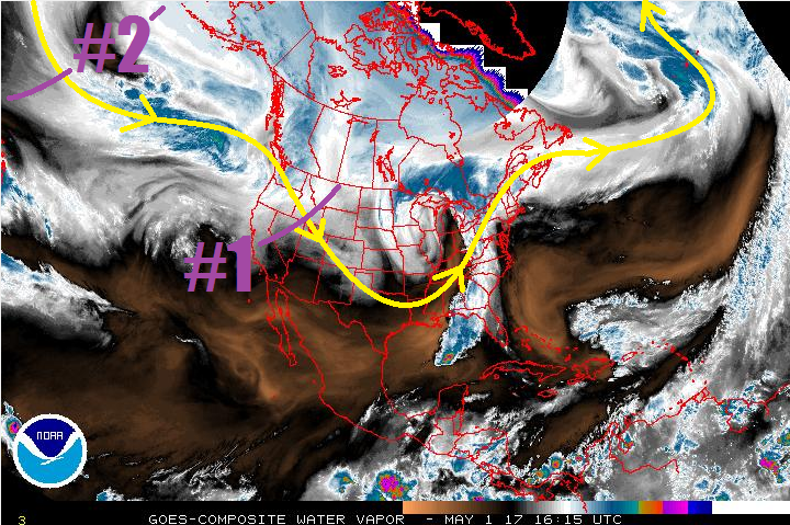
Event #2 shows up well in the water vapor image above as a trough over the Northern Pacific. This trough will continue to deepen as it advances towards the Continental US, with southerly flow ahead of it bringing subtropical moisture into region. From the base of the trough, a cutoff low is expected to develop, separating itself from the main atmospheric flow. This will cause the upper-low to linger over the southwestern US, bringing an extended period of unsettled weather to Colorado. With a setup like this, not only will there be concern for periods of heavy rain, but also severe weather across eastern Colorado. Fine details like those will be resolved in the coming days, so stay tuned to daily FTB’s and Thursday’s FTO for updated information.
Event #1: Tuesday (05-02-2017) and Wednesday (05-03-2017)
No Apparent Threat for Disorganized Trough with Limited Moisture
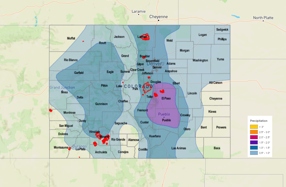
The disorganized trough will come through on the heels of the more impressive recent low pressure system, which will limit its ability to draw moisture into the area. The mountains will see a decent shot of snow, while the plains will see scattered-to-widespread rain showers. A couple thunderstorms cannot be ruled out, but they will lack the moisture to produce any sort of flood threat. The heaviest rain, relatively speaking, will fall across the Southeast Plains. Totals are not expected to top 0.5 inches, so no precipitation map will be drawn.
Event #2: Saturday (05-06-2017) through Thursday (05-11-2017)
Elevated Flood Threat Taking Shape
The upcoming system associated with Event #2 is one to keep an eye on. This type of setup will result in an extended period of unsettled weather, and the longer the upper-low lingers to our southwest, the more moisture that will be transported into Colorado. Those details will be resolved as we get closer to the event. Saturday/Sunday will be a nice precursor to the “main” portion of the event, as the first good batch of moisture arrives and instability develops. Monday-Tuesday-Wednesday will be the stretch with the best overlap of moisture and environmental support, and Thursday will be the final gasp of the moisture and lingering showers. Stay tuned to the FTO on Thursday more updated look at this event.