Issue Date: 9/29/2016
Issue Time: 2:50 PM

Well, the day is finally upon us to issue the final Flood Threat Outlook of the 2016 season. As always, it has been a pleasure to serve you and to provide these valuable products. Before jumping into the discussion of this FTO period, I wanted to take a look farther down the road and discuss how things look in the long-term. The image below is the Drought Monitor for the state of Colorado, released this morning (09-29-2016).
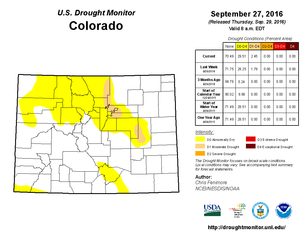
While much of the state remains without drought, a large swath of abnormally dry conditions has taken hold across portions of Colorado, particularly for northern areas. In additional, moderate drought conditions are depicted along the Front Range/Urban Corridor, and across the Palmer Ridge region. A drought, while never a good thing, is not as alarming this time of year as compared to one developing in the spring time. This is due to the fact that, climatologically speaking, precipitation drops off sharply between August and September, and a bit more into October. If this drought were creeping up during the spring when Colorado typically sees its highest rain and snow, the cause for concern would be greater. This situation is something to keep an eye on moving forward, and will be important to monitor going into next spring, when its impacts could become more profound. Now, let’s jump back into the present time period and discuss this FTO period.
There are two events in the upcoming period, both occurring within the first 6 days. Event #1 is the continuation of an event already underway, associated with the weakening upper-level low drifting northward across the Great Basin. This upper-level low has brought a subtropical surge to western Colorado, highlighted by the green arrow in the water vapor image below. Eventually, the low will wash out in the mean flow, with the lingering moisture providing fuel for a few more days of lingering showers across the High Country and Western Slope. No flood threat is apparent with this event, as rain rates are expected to remain well below flash flood thresholds.
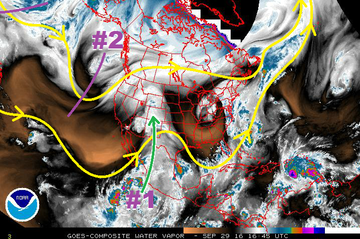
Event #2 is depicted in the water vapor image as an upper-level trough currently positioned off the West Coast. This trough, and developing closed low, will shift into the Great Basin on Monday, bringing strong southwesterly winds aloft to the region. Concurrently, a surface low will develop, with an attendant cold front sweeping across the area. Along the front, a few storms may become strong over the High Country and Western Slope, owing to sufficient shear and instability. These storms alone are the cause for any flooding concerns, and this is the reason behind the gradient in the threat timeline at the top of the page. Any flood threat that may develop will be low-end, but is worth mentioning in this FTO, as there will not be an FTB produced due to it being out of season. Behind the front, on Tuesday and Wednesday, cooler air from the northwest will invade the state, dropping snow levels to around 6,000-7,000 feet across the Northwest Slope, Northern Mountains, Central Mountains, and Grand Valley regions. A potentially significant early season snow event may unfold across the higher terrain, so be sure and stay tuned to your local National Weather Service offices for more information.
After Event #2, high pressure is expected to build across the region for an extended period of time; at least through the end of this FTO period. This will lead to dry and pleasant conditions for the state by October standards. For more information on events #1 and #2, including precipitation maps, please jump below to the event-specific discussions.
Event #1: Friday (09-30-2016) through Sunday (10-02-2016)
No Apparent Threat as the Upper-Low Weakens/Washes Out
The weakening upper-level low will continue to drift northward across the Great Basin, eventually washing out into the mean upper-level flow. The subtropical moisture surge that it has brought to western Colorado, however, will continue, lingering across the region. This will provide the fuel for a couple more days of showers, and perhaps an isolated thunderstorm or two. Due to lacking upper-level support and instability, rain rates are expected to stay below flash flood thresholds.

Event #2: Monday (10-03-2016) through Wednesday (10-05-2016)
Elevated Flood Threat for Monday, Followed by Snowfall
The upper-level trough, and developing closed low, will shift into the Great Basin on Monday. The dynamics associated with this trough will lead to the development of a surface low and attendant cold front. The cold front will sweep across the area on Monday, with showers/storms expected ahead of, and along, the front. A few storms may become strong over the High Country and Western Slope, owing to sufficient shear and instability. These stronger storms are the cause for any flooding concerns, and this is the reason behind the gradient in the threat timeline at the top of the page. On Tuesday/Wednesday, behind the front, cold air from the northwest will invade the state, dropping snow levels to around 6,000-7,000 feet, potentially leading to a significant early season snow event across the higher terrain. In the precipitation map below, both the rainfall and snowfall are depicted as a liquid equivalent. Not all of what is depicted will fall as rain, and snow totals may reach over a foot in higher elevations. Stay tuned to your local National Weather Service office for more details as this event approaches.