Issue Date: 9/26/2016
Issue Time: 10:55 AM

Colorado has settled into the first week of Fall nicely, with chilly temperatures across the state ringing in the day this morning. With the transition to Autumn, however, comes a climatological increase in the frequency of low pressure systems moving across the Continental United States. Gone is the steady summer ridge, replaced by transient upper-level troughs/ridges. Early in this period (Tuesday/Wednesday), dry conditions will prevail as the upper-level ridge will keep stable conditions in place across Colorado. By Thursday, however, a disturbance (purple circle, #1) will move out of the desert southwest and across the region, bringing subtropical moisture back into the state. Precipitation will be focused west of the Continental Divide on Thursday, spreading eastward and including the rest of the High Country (including the Front Range/Southeast Mountains) and adjacent low elevations for Friday/Saturday. By Sunday, the slow-moving disturbance will be northeast of Colorado, with the next event gathering itself over the Pacific Northwest.
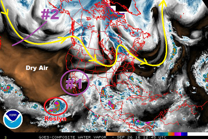
Sunday through Tuesday (10/2 – 10/4) have been included in the time frame of Event #2 on the timeline, but little precipitation is expected during those days. Drier and cooler air behind the first disturbance will keep precipitation hindered, but southwesterly flow aloft and weak support from the approaching upper-level low (purple line, #2) will allow for isolated light showers over the High Country during the early week days. The main show, so to speak, is expected mid-week (Wednesday, 10/5), as the upper-level low brings broad-scale support aloft and a surface low over southeast Colorado provides upslope flow. There is uncertainty in the amount of moisture that will be available to this activity, as the location of the surface low will play a role in the resultant moisture return. Right now, the best moisture looks like it will exist across the far eastern plains and into Kansas, so no flood threat is apparent at this time. We will monitor this event closely, and have an update on the time frame in Thursday’s FTO.
Ensemble models hint at an Event #3 following closely behind Event #2, best characterized as a reinforcing wave, or a “double-dip” from the parent upper-level low over Canada. Event #3 also looks to take a more northern track, leaving Wyoming to deal with the heavier precipitation, relatively speaking, while Colorado deals with showers and High Country snow. Stay tuned.
Event #1: Thursday (09-29-2016) through Saturday (10-01-2016)
No Apparent Threat as Showers will be the Dominant Rain Type, Isolated Thunderstorms
A disturbance, currently positioned over the Desert Southwest/California Baja, will slide across the region, bringing subtropical moisture back into Colorado. Precipitation will be focused west of the Continental Divide on Thursday, spreading eastward and including the rest of the High Country (including the Front Range/Southeast Mountains) and adjacent low elevations for Friday/Saturday. No flood threat is apparent at this time, but some locations across far western Colorado may receive a total of 1.0 inches by the end of the three day event.

Event #2: Sunday (10-02-2016) through Thursday (10-06-2016)
No Apparent Flood Threat as Moisture Likely Stays out of State
While Event #2 is categorized as a five-day event, the main show will occur during the mid-week, likely on Wednesday, October 5th. On that day, the best combination of upper-level support, upslope flow, and low-level moisture return will bring the threat of showers/thunderstorms to eastern Colorado. The best moisture appears to be withheld across Kansas, lessening the threat of heavy rain in Colorado. No flood threat is apparent at this time as we await clarification on the magnitude of moisture return.
Event #3: Friday (10-07-2016) through Sunday (10-09-2016)
No Apparent Flood Threat as the Double-Dip Favors Lighter Precipitation
Ensemble models hint at an Event #3 following closely behind Event #2, but at this time it appears to favor a more northern track. This would leave Colorado with mainly showers and High Country snow, and not a flood threat. A more southerly track would change those results, but it is uncertain at this time. Due to this uncertainty, and the current forecast that no locations would receive more than 0.5 inches of rainfall, no precipitation map will be drawn.