FTO 06-01-2017: Hot West of The Continental Divide Means Snow Melt Quickens; One Flood Threat Identified

Issue Date: Thursday, June 1st, 2017
Issue Time: 3:00PM MDT
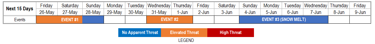
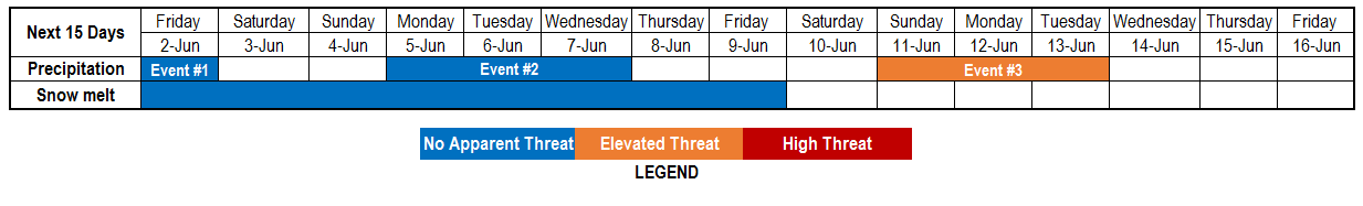
Valid Dates: 6/2 – 6/16

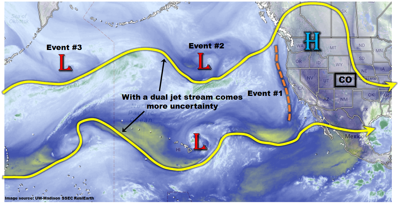
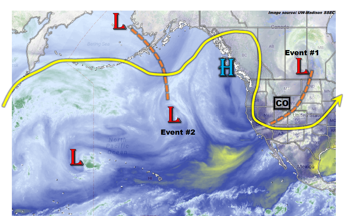
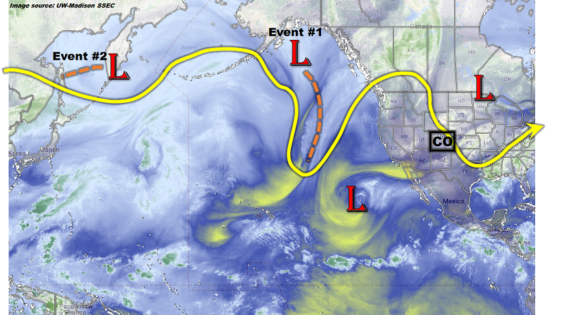
In sharp contrast to the jet stream pattern observed just three days ago (see previous Flood Threat Outlook from 5/29), today’s pattern (see water vapor image below) shows one, nearly continuous jet stream across the northern Pacific Ocean. Closer to home, an upper-level ridge is currently positioned over the northern US Great Plains, allowing for seasonably warm temperatures across our state. A cut-off disturbance currently over southwest New Mexico is causing scattered showers and storms today, though the flood threat is limited. We expect this low pressure to affect Colorado through Friday, which is categorized as Event #1. Very isolated heavy rainfall is possible with this, but no flood threat is anticipated.

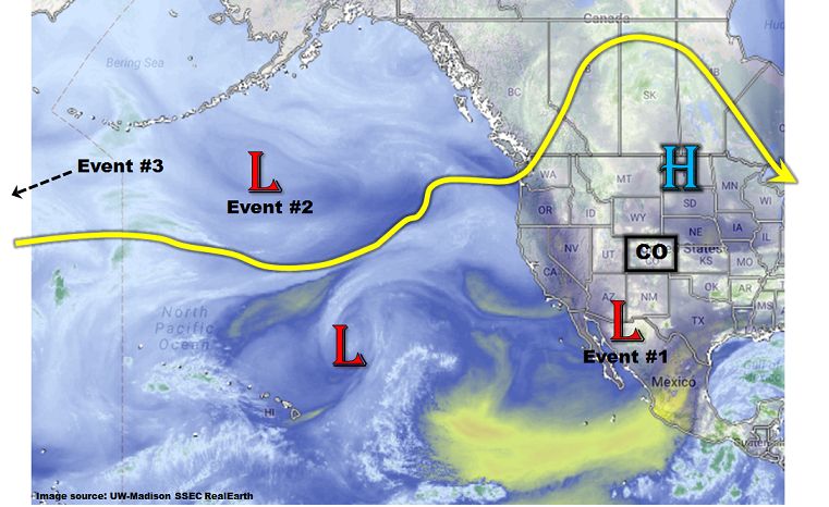
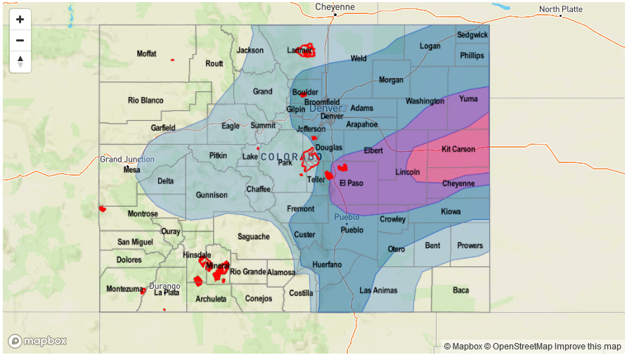
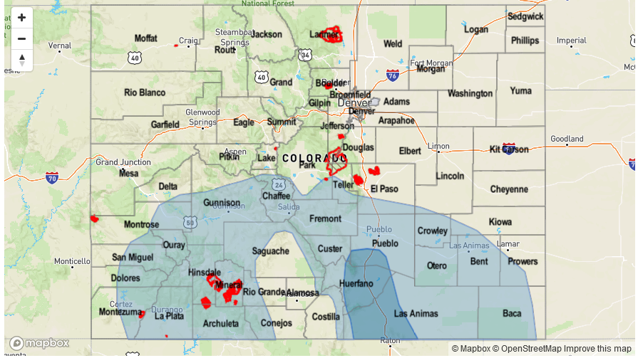
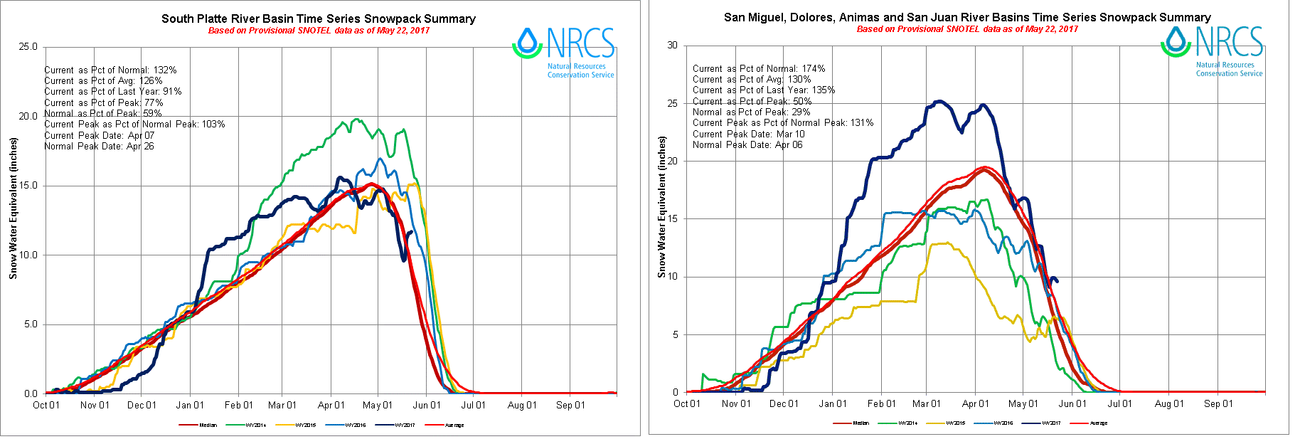
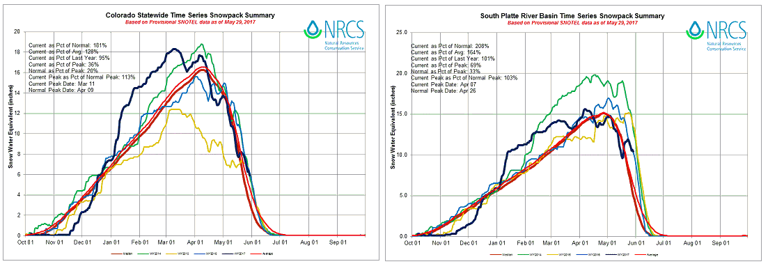
After this cut-off low moves to the east, the high pressure will re-establish control over Colorado, causing a multi-day period of very warm to hot weather. This will be especially true west of the Continental Divide, where temperatures are expected to average 5-15F above normal for a 5-7 day stretch beginning on Friday. Needless to say, this will take a strong toll on the remaining snow pack, which we expect to be mostly gone by this time next week. The left chart below shows that the statewide Snow Water Equivalent is running almost twice above normal (though this reading is partially due to a “divide by a small number” effect given that the average SWE statewide is currently less than 3 inches). However, of particular interest is the South Platte River which still has an average SWE above 10 inches. Fortunately, because the largest positive temperature anomalies are expected to remain west of the Continental Divide, we do not foresee a significant flood threat even for the South Platte basin from snow melt this year. However, localized streams and creeks in the Colorado River and South Platte River basins are likely to see some minor flooding. We will monitor these details in daily Flood Threat Bulletins.

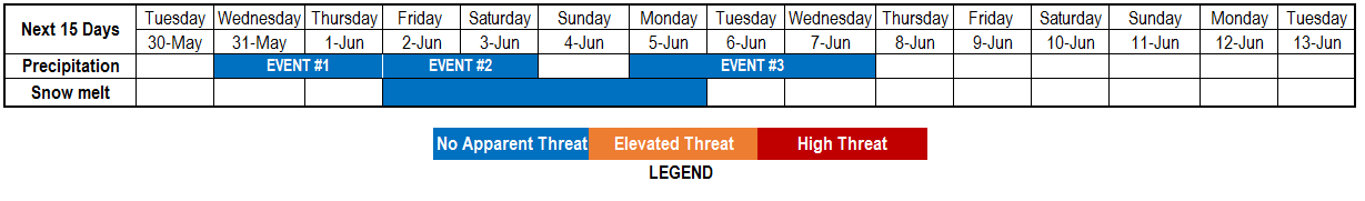
Shifting the focus back to precipitation, we have identified two other “Events” in addition to Event #1 that will provide elevated precipitation chances for Colorado over the next 15 days. These are described below.

Event #1: Friday (6/2)

No Anticipated Flood Threat a round of showers and weak storms likely across the Northeast Plains

As a cut-off low pressure systems moves across New Mexico, one more day of shower and storm activity is expected across the state. Similar to the past few days, instability will not be lacking with morning sunshine igniting early afternoon storms across the Front Range and Central Mountains. However, with wind shear continuing to be weak, sustained heavy rainfall appears unlikely. Instead, we anticipate a broad region of 0.25 to 0.5 inches of precipitation with higher amounts in the Northeast Plains where up to 1.0 inch could fall as storms get a bit better organized. However, with flash flood guidance exceeding 1.5 inches per hour in this region, we do not anticipate a flood threat.

Legend

Event #2: Monday (6/5) through Wednesday (6/7)

No Anticipated Flood Threat as heavy rainfall threat is suppressed

The disturbance that will bring about Event #2 will face similar long odds as Event #1, because it will be outmatched by the high pressure ridge. Expect a three day period of scattered to numerous showers and weak storms starting in the higher terrain and then spreading into the Palmer and Raton ridges. With plenty of low-level moisture, isolated heavy rainfall cannot be ruled out, but the flood threat remains suppressed. Nonetheless, up to 1.25 inches of precipitation is possible over this period especially in the higher elevations and foothills of southern Colorado.

Legend

Event #3: Sunday (6/11) through Tuesday (6/13)

Elevated Flood Threat as disturbance approaches the state from the west

A disturbance currently in the far western Pacific Ocean is expected to rapidly move eastward within the elongated jet stream. It is expected to affect our weather starting Sunday 6/11 for regions west of the Continental Divide, and one to two more days for regions east of the Divide. West of the Divide, the flood threat appears subdued because the disturbance will be transporting in drier air. However, east of the Divide, with moist upslope flow available, a day or two of heavy rainfall looks increasingly likely. In typical fashion, expect early storms to erupt in the higher terrain of the Front Range and Southeast Mountains, then move to the east. The eastward extent of the precipitation is currently uncertain, but it is possible that organized heavy rainfall producing storms could make it to the Kansas border. At this time, the precipitation map below is limited to 1.5 inches or less, but stay tuned to future Flood Threat Outlooks as we update this event’s forecast.

Legend

FTO 05-29-2017: Prolonged Stretch of Elevated Moisture But Flood Threat Uncertain; Snow Melt To Pick Up Speed

Issue Date: Monday, May 29th, 2017
Issue Time: 12:40PM MDT
Valid Dates: 6/30 – 6/13

Today’s North Pacific Ocean water vapor imagery, below, shows that two distinct jet streams (polar and subtropical) spanning all the way into North America’s west coast. Within each of these are embedded large-scale disturbances that will, at various speeds, continue their march eastward. Also of note is a strong upper-level ridge that is centered across the US Pacific Northwest. This is causing much above normal temperatures across WA, OR and ID. The ridge will never make much progress into Colorado over the next 15-days but will occasionally bulge in, causing above normal temperatures especially west of the Continental Divide. This will cause a multi-day period of enhanced snow-melt next weekend, and we have incorporated this by adding a new “Snow melt” category in our timeline above. At this time, base flows are well below flood stage for a majority of streams; thus, we foresee a generally orderly melt-off though there will undoubtedly be localized regions that will need to be monitored for low-grade flooding.

Moving back to the precipitation topic, an unusual amount of uncertainty exists for this forecast period due to the continuous interaction between the two jet streams. Essentially, it will be difficult to ascertain the degree to which disturbances will cut-off from the main flow, which would dictate their speed of travel and thus, the longevity of their precipitation threat. Nonetheless, there is significant amount of certainty that moisture will be in abundance beginning later this week, as shown in the GFS Ensemble plumes for Denver’s precipitable water (PW) forecast, below. The climatological value is about 0.5-0.55 inches for early June. However, a majority of ensembles show above average values, with several showing values greater than 1 inch, for a prolonged stretch. As PW is a strong predictor of heavy rainfall in Colorado, it is likely that at least isolated heavy rainfall will been seen east of the Continental Divide over the next 7-10 days. This chart is indicative of conditions east of the Continental Divide. West of the Continental Divide, moisture is anticipated to be closer to normal, meaning chances of flooding are not as great. Unfortunately, placing the location of heavy rainfall is more of a challenge.

We have identified 3 “Events” that will provide elevated precipitation chances for Colorado over the next 15 days. These are described below.

Event #1: Wednesday (5/31) through Thursday (6/1)

No Anticipated Flood Threat as precipitation chances increase in southwest and eastern Colorado

A shortwave disturbance will affect Colorado from the southwest beginning Wednesday and continuing into Thursday. Precipitation coverage will first increase in the San Juans and Southwest Slope on Wednesday then spread eastward over the Continental Divide on Thursday. On Wednesday, expect localized heavy rainfall with up to 0.5 inches possible in isolated locations of southwest Colorado and up to 0.75 inches in the foothills east of the Continental Divide. On Thursday, up to 1 inch of rainfall will be possible along the entire I-25 corridor, Palmer Ridge and Raton Ridge. At this time we are not providing a precipitation map because the precipitation coverage is not certain, and the heavy rainfall should be quite isolated. Stay tuned to daily Flood Threat Bulletins for more detail on each day.

Event #2: Friday (6/2) and Saturday (6/3)

No Anticipated Flood Threat as daily precipitation likely mainly east of the Continental Divide

Immediately following Event #1, another larger disturbance is expected to make a dent into the Pacific Northwest Ridge and affect Colorado. However, the ridge will continue to hold its ground, making conditions unfavorable for large-scale precipitation. While daily precipitation chances are likely statewide, and especially east of the Continental Divide, there is too much uncertainty to warrant a precipitation map. Isolated daily rainfall amounts up to 1 inch are possible given the instability and moisture. However, the precipitation coverage does not appear to be large enough to support a flood threat at this time.

Event #3: Monday (6/5) through Wednesday (6/7)

No Anticipated Flood Threat due to uncertainty in whether disturbance will make it to Colorado

Unlike Events #1 and 2, the main uncertainty with Event #3 is whether or not it will make it into Colorado. Enough of a consensus exists that supports an increase in precipitation chances first west of the Continental Divide on Monday, then spreading east on Tuesday and Wednesday. Similar to Event #2, it appears that at least a weak ridge will continue to maintain a position over Colorado. Thus, while isolated precipitation is likely, coverage is not certain at this time. The next Flood Threat Outlook (to be issued on Thursday) should provide more confidence on this event.


FTO 05-25-2017: Two Elevated Flood Threat Events, Then Snow Melt Begins In Earnest Later Next Week

Issue Date: Thursday, May 25th, 2017
Issue Time: 3:00PM
Valid Dates: 5/26 – 6/9

In today’s eastern Pacific water vapor imagery, shown below, we get a glimpse at many of the features that will be affecting Colorado’s weather over the next 15 days. The first feature is the disturbance located over southern Canada with a trough draped southwest across Colorado. This will provide a few days of elevated flood threat conditions mainly for isolated flash flooding (along with severe weather) in eastern Colorado. Looking slightly farther west we see a ridge of modest strength located just offshore of North America. This ridge will attempt to bulge into Colorado but should be help back from doing so over the next week or so, in part due to the disturbance that will be causing our second precipitation event (Event #2) next week. Thereafter, the ridge will appear to regain the upper hand which will provide an extended warm period for most of the state. With a healthy snowpack still in place, we have labeled Event #3 as a string of days where substantial melt is expected.

Below we describe each Event in more detail.

Event #1: Friday (5/26) through Sunday (5/28)

Elevated Flood Threat through Saturday for eastern Colorado, followed by more steady rain

The upper-level trough responsible for today’s (Thursday) shower and storm activity will actually generate a daily low-level circulation east of the Continental Divide. Friday’s system will have the best chances of generating widespread heavy rainfall. We anticipate 1-2 waves of organized shower and storm activity beginning late morning over the higher terrain, then moving east into the Plains. Very heavy rainfall will be possible especially towards the Kansas border, with max 1-hour rain rates up to 2.4 inches and 3-hour rain rates up to 2.9 inches. Isolated flash flooding will accompany the strongest storms, and street flooding will be likely for low-lying municipal areas. In addition to the heavy rainfall, severe weather in the form of large hail (up to 2.5 inches), damaging winds (up to 75mph) and isolated tornadoes will be possible. Heading into Saturday, cooler, more stable air will slowly overtake northern Colorado, but instability will still be present in the southeast. At least one round of showers and storms will develop across the Southeast Plains with 1-hour rain rates up to 1.6 inches, causing isolated flash flooding. By Sunday, cooler air will overtake most of the state, but residual moisture will allow for upslope shower and maybe a weak thunderstorm. However, flooding is not expected on Sunday.

Legend


Event #2: Wednesday (5/31) through Thursday (6/1)

Elevated Flood Threat as disturbance approaches Colorado from the southwest

After a short break following Event #1, a southern stream disturbance will penetrate through the west coast ridge and will affect mainly southern Colorado beginning Wednesday 5/31. The strength of the atmospheric dynamics are uncertain right now, but it does appear that there will be enough moisture for at least isolated thunderstorms capable of producing heavy rainfall. The areas most likely to be impacted are the San Juans, stretching east into southeast Colorado. Up to 1.5 inches of rainfall will be possible, based on current guidance.

Legend

Event #3: Sunday (6/4) through Wednesday (6/7)

Snow melt to accelerate but No Anticipated Flood Threat at this time

A high-pressure ridge will begin to control the western North American circulation starting later next week. High temperatures will climb to above normal levels for a multi-day period, allowing for high-elevation snow melt to begin in earnest. Locations below 9,000 feet have already generally melted out (with some exceptions due to the recent late season snowstorm). However, a solid snowpack remains above 9,000 feet. At this time, only modestly above average temperatures are expected, thus we do not expect major flood-related issues. However, this will need to be monitored. The basins that are most prone to snow-melt related high flows will be the South Platte and San Juan region, as shown in the SWE charts below. Nonetheless, other isolated locations with a high snowpack may be vulnerable to high flows as well. Time to book those rafting trips, if you have not already done so!

FTO 05-22-2017: High Flood Threat Anticipated Later This Week

Issue Date: Monday, May 22nd, 2017
Issue Time: 2:45PM MDT
Valid Dates: 5/23 – 6/6

Last week’s snowstorm has finally departed, but its impacts have not. The low-pressure that was responsible for the late spring snows along the Front Range has helped carve out a strong, large-scale trough centered over northern Minnesota as of this afternoon (see water vapor image below). The main sensible features from this trough have been a string of cooler than normal days across most of the state and frequent (but generally light intensity) precipitation. In turn, the cooler weather has helped refrigerate a sizeable snowpack across the higher terrain.

Looking forward over the next 15 days, we anticipate the first seven days of the period to continue to be impacted by the Central Plains trough. In fact, an interesting situation appears to be in the making as another strong disturbance, currently in the Gulf of Alaska, enters the west coast over the next 48-72 hours. During that time period, there is enough consensus that return flow will have time to re-establish itself east of the Continental Divide. With a return to near-seasonal temperatures by Thursday, there will be sufficient instability for a multi-day flood threat across eastern Colorado. At this time, it appears that over Thursday (5/25) through Saturday (5/27), each day will have a possibility of at least isolated flooding. However, an especially strong consensus in guidance and historical analogs pegs Friday as the day with the highest chances of widespread heavy rainfall and flash flooding.

The three maps below show the probability of Convective Available Potential Energy exceeding 500 J/kg (a rough guideline for heavy rainfall potential) for the past 3 forecast cycles of the GFS ensembles. A widespread swath of probabilities exceeding 50% is found across eastern Colorado for Friday afternoon. Analysis of moisture fields shows that Precipitable Water values will approach or exceed 1 inch in far eastern areas, and a long fetch of moisture advection will be likely. The only possible complication is if cool, stable air overtakes the entire area, which is looking very improbable right now. Although it is difficult to ascertain the severity of potential flooding, it does appear likely that at least isolated flash flooding will occur; hence the High flood threat.

After Event 1’s trough moves eastward, expect a return to quieter and warmer weather statewide. There is enough consensus to identify another precipitation event, Event #2, currently located in the far western Pacific Ocean. However, as this disturbance will likely be battling a high-pressure ridge, it does not currently warrant any flood threat, though that could change.

In addition to the precipitation events, consistently warmer weather is slated to begin after the passage of Event #1. With the recently rejuvenated snowpack, snow melt-driven high river and stream flows will need to be monitored. We should have a better grasp of the degree of warm weather in the next update of the Flood Threat Outlook, scheduled for this Thursday (5/25).

Below we describe each of the two identified Events in more detail.

Event #1: Thursday (5/25) through Saturday (5/27)

Elevated/High Flood Threat likely for eastern Colorado

Thursday will mark the first day of the flood threat as showers are expected in scattered to numerous coverage statewide, with thunderstorms mainly east of the Continental Divide. Maximum hourly rain rates up to 1.6 inches will be possible, with max 24-hour rainfall exceeding 2 inches. Hail will be possible with the strong storms, and a tornado threat appears possible towards the Kansas border. For Friday, it is likely that some cooler, less unstable air will begin to affect northern Colorado. In this region, light to moderate rainfall will occur, perhaps amounting to 1 inch. Farther south and east, instability will be adequate enough to continue to fuel multiple rounds of showers and thunderstorms. Up to 2 inches of rainfall will be possible. With increasingly wet soils, it appears runoff will be particularly efficient and thus both flash flooding and possible riverine flooding could occur. It is difficult to anticipate whether the riverine flooding will be limited to tributaries or the main rivers. However, the downstream portions of the South Platte and Arkansas rivers could both end up in at least Minor flood stage. Hail could also accompany some of the stronger storms on Friday, though this could be mitigate if convection is organized into larger segments (which would be more conducive to a flood threat). By Saturday, the cool, stable air mass will likely overtake most of Colorado except for parts of the Southeast Plains. There, continued storm activity is likely to cause isolated heavy rainfall that could fall over already wet soils. At this time, it appears that the Front Range and Urban Corridor will not have sufficient instability for widespread, long-duration heavy rainfall. However, this is not certain and will be monitored over the next few days.

Legend


Event #2: Wednesday (5/31) through Thursday (6/1)

No Anticipated Flood Threat as disturbance approaches Colorado from the southwest

After a respite following Event #1, warmer weather will overtake most of Colorado. A disturbance is forecasted to approach the west coast by the middle of next week. Should it make it to Colorado, there will likely be a flood threat as moisture levels appear to be high enough to generate a heavy rainfall threat. However, at this time, the precipitation map below captures the regions that are most likely to be affected by rainfall. Stay tuned to updates on this event in ensuing Flood Threat Outlooks.

Legend