Issue Date: Monday, May 29th, 2017
Issue Time: 12:40PM MDT
Valid Dates: 6/30 – 6/13
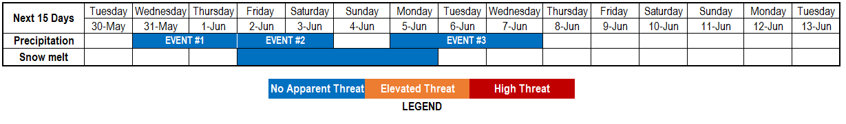
Today’s North Pacific Ocean water vapor imagery, below, shows that two distinct jet streams (polar and subtropical) spanning all the way into North America’s west coast. Within each of these are embedded large-scale disturbances that will, at various speeds, continue their march eastward. Also of note is a strong upper-level ridge that is centered across the US Pacific Northwest. This is causing much above normal temperatures across WA, OR and ID. The ridge will never make much progress into Colorado over the next 15-days but will occasionally bulge in, causing above normal temperatures especially west of the Continental Divide. This will cause a multi-day period of enhanced snow-melt next weekend, and we have incorporated this by adding a new “Snow melt” category in our timeline above. At this time, base flows are well below flood stage for a majority of streams; thus, we foresee a generally orderly melt-off though there will undoubtedly be localized regions that will need to be monitored for low-grade flooding.
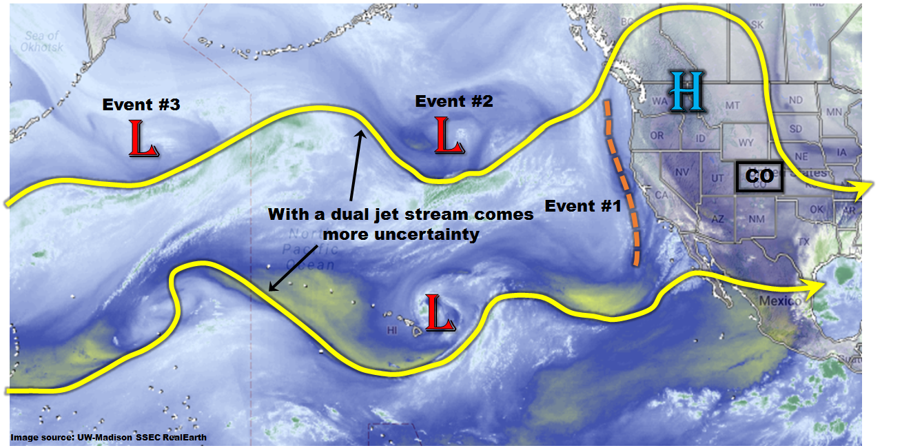
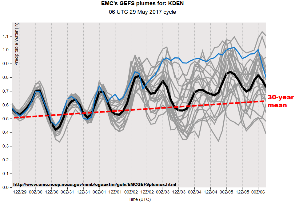
Moving back to the precipitation topic, an unusual amount of uncertainty exists for this forecast period due to the continuous interaction between the two jet streams. Essentially, it will be difficult to ascertain the degree to which disturbances will cut-off from the main flow, which would dictate their speed of travel and thus, the longevity of their precipitation threat. Nonetheless, there is significant amount of certainty that moisture will be in abundance beginning later this week, as shown in the GFS Ensemble plumes for Denver’s precipitable water (PW) forecast, below. The climatological value is about 0.5-0.55 inches for early June. However, a majority of ensembles show above average values, with several showing values greater than 1 inch, for a prolonged stretch. As PW is a strong predictor of heavy rainfall in Colorado, it is likely that at least isolated heavy rainfall will been seen east of the Continental Divide over the next 7-10 days. This chart is indicative of conditions east of the Continental Divide. West of the Continental Divide, moisture is anticipated to be closer to normal, meaning chances of flooding are not as great. Unfortunately, placing the location of heavy rainfall is more of a challenge.
We have identified 3 “Events” that will provide elevated precipitation chances for Colorado over the next 15 days. These are described below.
Event #1: Wednesday (5/31) through Thursday (6/1)
No Anticipated Flood Threat as precipitation chances increase in southwest and eastern Colorado
A shortwave disturbance will affect Colorado from the southwest beginning Wednesday and continuing into Thursday. Precipitation coverage will first increase in the San Juans and Southwest Slope on Wednesday then spread eastward over the Continental Divide on Thursday. On Wednesday, expect localized heavy rainfall with up to 0.5 inches possible in isolated locations of southwest Colorado and up to 0.75 inches in the foothills east of the Continental Divide. On Thursday, up to 1 inch of rainfall will be possible along the entire I-25 corridor, Palmer Ridge and Raton Ridge. At this time we are not providing a precipitation map because the precipitation coverage is not certain, and the heavy rainfall should be quite isolated. Stay tuned to daily Flood Threat Bulletins for more detail on each day.
Event #2: Friday (6/2) and Saturday (6/3)
No Anticipated Flood Threat as daily precipitation likely mainly east of the Continental Divide
Immediately following Event #1, another larger disturbance is expected to make a dent into the Pacific Northwest Ridge and affect Colorado. However, the ridge will continue to hold its ground, making conditions unfavorable for large-scale precipitation. While daily precipitation chances are likely statewide, and especially east of the Continental Divide, there is too much uncertainty to warrant a precipitation map. Isolated daily rainfall amounts up to 1 inch are possible given the instability and moisture. However, the precipitation coverage does not appear to be large enough to support a flood threat at this time.
Event #3: Monday (6/5) through Wednesday (6/7)
No Anticipated Flood Threat due to uncertainty in whether disturbance will make it to Colorado
Unlike Events #1 and 2, the main uncertainty with Event #3 is whether or not it will make it into Colorado. Enough of a consensus exists that supports an increase in precipitation chances first west of the Continental Divide on Monday, then spreading east on Tuesday and Wednesday. Similar to Event #2, it appears that at least a weak ridge will continue to maintain a position over Colorado. Thus, while isolated precipitation is likely, coverage is not certain at this time. The next Flood Threat Outlook (to be issued on Thursday) should provide more confidence on this event.