Issue Date: Monday, May 22nd, 2017
Issue Time: 2:45PM MDT
Valid Dates: 5/23 – 6/6

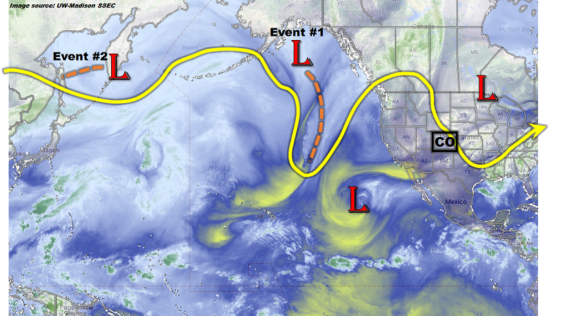
Last week’s snowstorm has finally departed, but its impacts have not. The low-pressure that was responsible for the late spring snows along the Front Range has helped carve out a strong, large-scale trough centered over northern Minnesota as of this afternoon (see water vapor image below). The main sensible features from this trough have been a string of cooler than normal days across most of the state and frequent (but generally light intensity) precipitation. In turn, the cooler weather has helped refrigerate a sizeable snowpack across the higher terrain.
Looking forward over the next 15 days, we anticipate the first seven days of the period to continue to be impacted by the Central Plains trough. In fact, an interesting situation appears to be in the making as another strong disturbance, currently in the Gulf of Alaska, enters the west coast over the next 48-72 hours. During that time period, there is enough consensus that return flow will have time to re-establish itself east of the Continental Divide. With a return to near-seasonal temperatures by Thursday, there will be sufficient instability for a multi-day flood threat across eastern Colorado. At this time, it appears that over Thursday (5/25) through Saturday (5/27), each day will have a possibility of at least isolated flooding. However, an especially strong consensus in guidance and historical analogs pegs Friday as the day with the highest chances of widespread heavy rainfall and flash flooding.
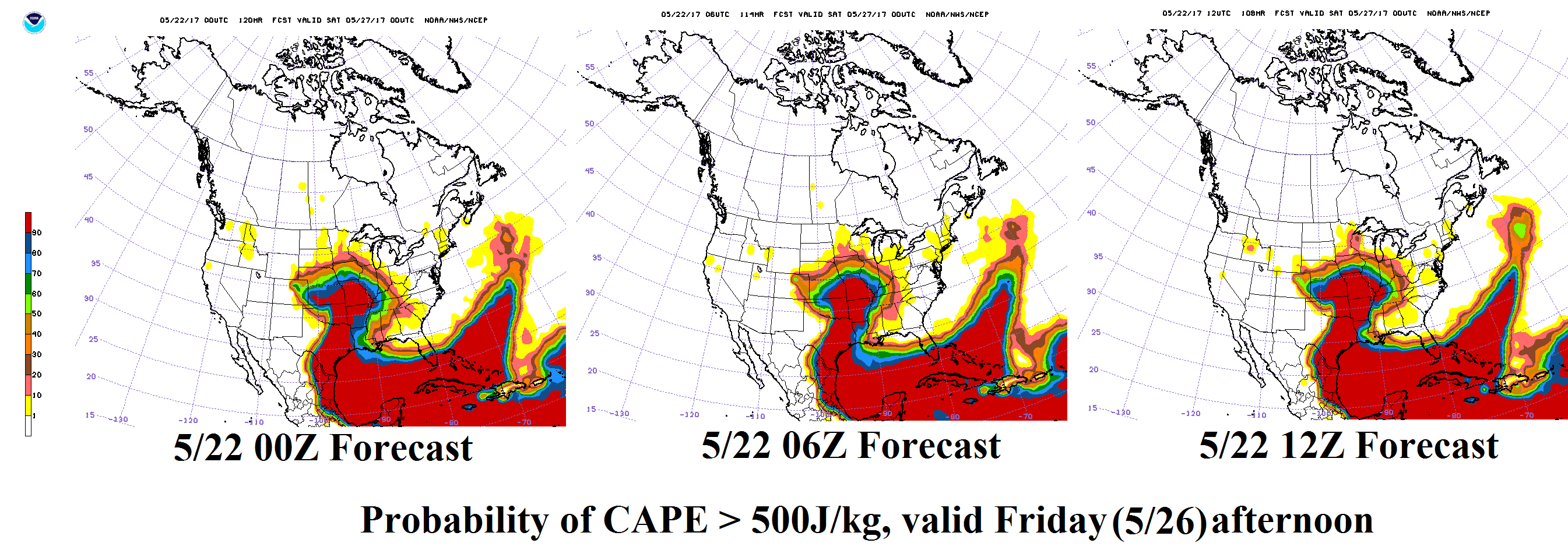
The three maps below show the probability of Convective Available Potential Energy exceeding 500 J/kg (a rough guideline for heavy rainfall potential) for the past 3 forecast cycles of the GFS ensembles. A widespread swath of probabilities exceeding 50% is found across eastern Colorado for Friday afternoon. Analysis of moisture fields shows that Precipitable Water values will approach or exceed 1 inch in far eastern areas, and a long fetch of moisture advection will be likely. The only possible complication is if cool, stable air overtakes the entire area, which is looking very improbable right now. Although it is difficult to ascertain the severity of potential flooding, it does appear likely that at least isolated flash flooding will occur; hence the High flood threat.
After Event 1’s trough moves eastward, expect a return to quieter and warmer weather statewide. There is enough consensus to identify another precipitation event, Event #2, currently located in the far western Pacific Ocean. However, as this disturbance will likely be battling a high-pressure ridge, it does not currently warrant any flood threat, though that could change.
In addition to the precipitation events, consistently warmer weather is slated to begin after the passage of Event #1. With the recently rejuvenated snowpack, snow melt-driven high river and stream flows will need to be monitored. We should have a better grasp of the degree of warm weather in the next update of the Flood Threat Outlook, scheduled for this Thursday (5/25).
Below we describe each of the two identified Events in more detail.
Event #1: Thursday (5/25) through Saturday (5/27)
Elevated/High Flood Threat likely for eastern Colorado
Thursday will mark the first day of the flood threat as showers are expected in scattered to numerous coverage statewide, with thunderstorms mainly east of the Continental Divide. Maximum hourly rain rates up to 1.6 inches will be possible, with max 24-hour rainfall exceeding 2 inches. Hail will be possible with the strong storms, and a tornado threat appears possible towards the Kansas border. For Friday, it is likely that some cooler, less unstable air will begin to affect northern Colorado. In this region, light to moderate rainfall will occur, perhaps amounting to 1 inch. Farther south and east, instability will be adequate enough to continue to fuel multiple rounds of showers and thunderstorms. Up to 2 inches of rainfall will be possible. With increasingly wet soils, it appears runoff will be particularly efficient and thus both flash flooding and possible riverine flooding could occur. It is difficult to anticipate whether the riverine flooding will be limited to tributaries or the main rivers. However, the downstream portions of the South Platte and Arkansas rivers could both end up in at least Minor flood stage. Hail could also accompany some of the stronger storms on Friday, though this could be mitigate if convection is organized into larger segments (which would be more conducive to a flood threat). By Saturday, the cool, stable air mass will likely overtake most of Colorado except for parts of the Southeast Plains. There, continued storm activity is likely to cause isolated heavy rainfall that could fall over already wet soils. At this time, it appears that the Front Range and Urban Corridor will not have sufficient instability for widespread, long-duration heavy rainfall. However, this is not certain and will be monitored over the next few days.

Event #2: Wednesday (5/31) through Thursday (6/1)
No Anticipated Flood Threat as disturbance approaches Colorado from the southwest
After a respite following Event #1, warmer weather will overtake most of Colorado. A disturbance is forecasted to approach the west coast by the middle of next week. Should it make it to Colorado, there will likely be a flood threat as moisture levels appear to be high enough to generate a heavy rainfall threat. However, at this time, the precipitation map below captures the regions that are most likely to be affected by rainfall. Stay tuned to updates on this event in ensuing Flood Threat Outlooks.