Issue Date: Thursday, May 25th, 2017
Issue Time: 3:00PM
Valid Dates: 5/26 – 6/9

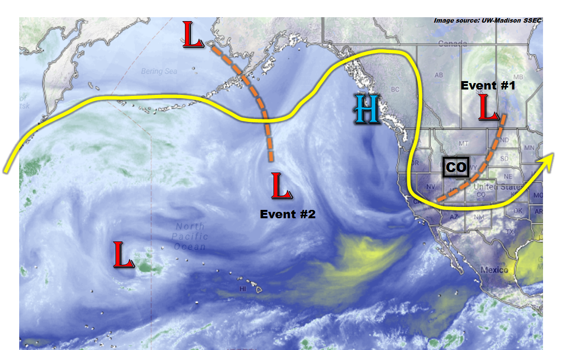
In today’s eastern Pacific water vapor imagery, shown below, we get a glimpse at many of the features that will be affecting Colorado’s weather over the next 15 days. The first feature is the disturbance located over southern Canada with a trough draped southwest across Colorado. This will provide a few days of elevated flood threat conditions mainly for isolated flash flooding (along with severe weather) in eastern Colorado. Looking slightly farther west we see a ridge of modest strength located just offshore of North America. This ridge will attempt to bulge into Colorado but should be help back from doing so over the next week or so, in part due to the disturbance that will be causing our second precipitation event (Event #2) next week. Thereafter, the ridge will appear to regain the upper hand which will provide an extended warm period for most of the state. With a healthy snowpack still in place, we have labeled Event #3 as a string of days where substantial melt is expected.
Below we describe each Event in more detail.
Event #1: Friday (5/26) through Sunday (5/28)
Elevated Flood Threat through Saturday for eastern Colorado, followed by more steady rain
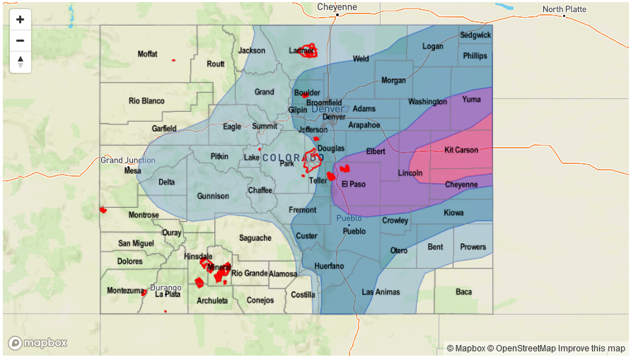
The upper-level trough responsible for today’s (Thursday) shower and storm activity will actually generate a daily low-level circulation east of the Continental Divide. Friday’s system will have the best chances of generating widespread heavy rainfall. We anticipate 1-2 waves of organized shower and storm activity beginning late morning over the higher terrain, then moving east into the Plains. Very heavy rainfall will be possible especially towards the Kansas border, with max 1-hour rain rates up to 2.4 inches and 3-hour rain rates up to 2.9 inches. Isolated flash flooding will accompany the strongest storms, and street flooding will be likely for low-lying municipal areas. In addition to the heavy rainfall, severe weather in the form of large hail (up to 2.5 inches), damaging winds (up to 75mph) and isolated tornadoes will be possible. Heading into Saturday, cooler, more stable air will slowly overtake northern Colorado, but instability will still be present in the southeast. At least one round of showers and storms will develop across the Southeast Plains with 1-hour rain rates up to 1.6 inches, causing isolated flash flooding. By Sunday, cooler air will overtake most of the state, but residual moisture will allow for upslope shower and maybe a weak thunderstorm. However, flooding is not expected on Sunday.

Event #2: Wednesday (5/31) through Thursday (6/1)
Elevated Flood Threat as disturbance approaches Colorado from the southwest
After a short break following Event #1, a southern stream disturbance will penetrate through the west coast ridge and will affect mainly southern Colorado beginning Wednesday 5/31. The strength of the atmospheric dynamics are uncertain right now, but it does appear that there will be enough moisture for at least isolated thunderstorms capable of producing heavy rainfall. The areas most likely to be impacted are the San Juans, stretching east into southeast Colorado. Up to 1.5 inches of rainfall will be possible, based on current guidance.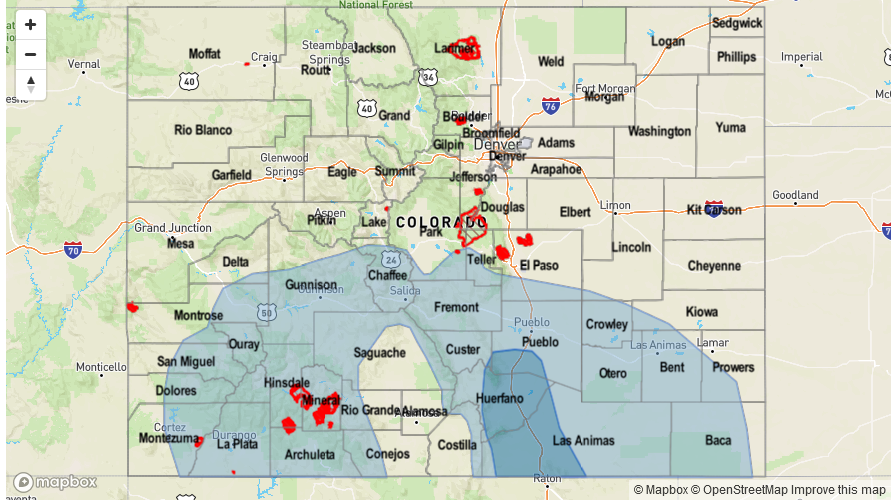
Event #3: Sunday (6/4) through Wednesday (6/7)
Snow melt to accelerate but No Anticipated Flood Threat at this time
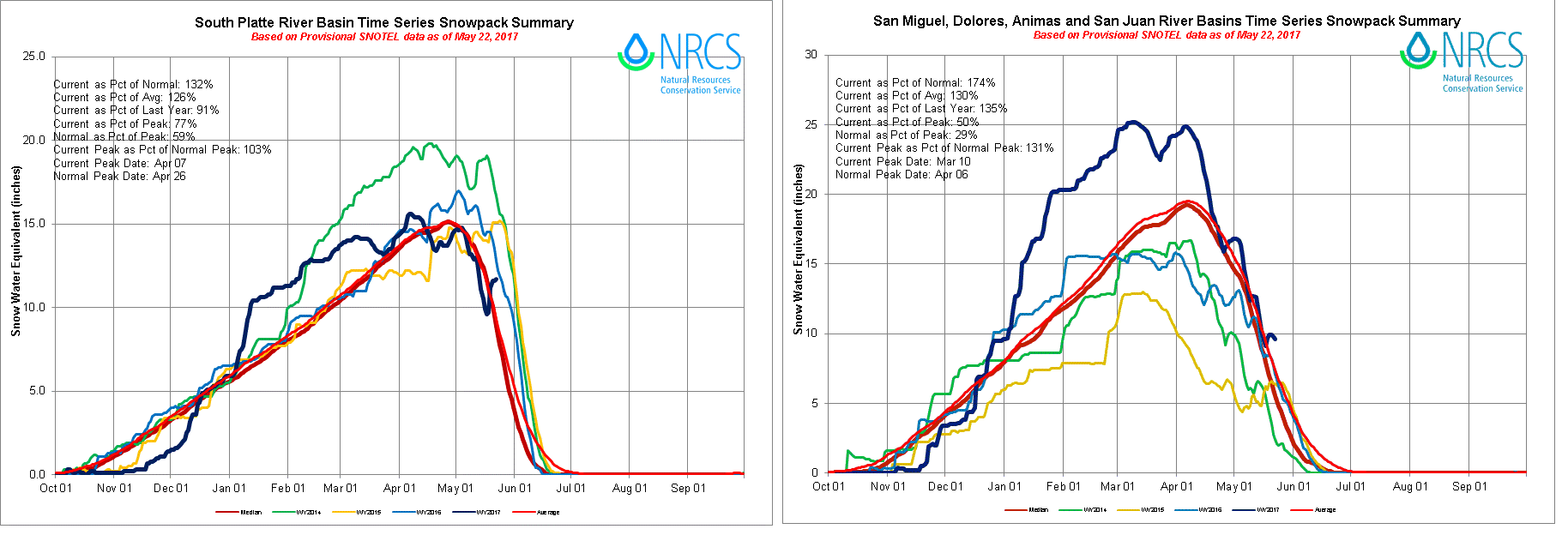
A high-pressure ridge will begin to control the western North American circulation starting later next week. High temperatures will climb to above normal levels for a multi-day period, allowing for high-elevation snow melt to begin in earnest. Locations below 9,000 feet have already generally melted out (with some exceptions due to the recent late season snowstorm). However, a solid snowpack remains above 9,000 feet. At this time, only modestly above average temperatures are expected, thus we do not expect major flood-related issues. However, this will need to be monitored. The basins that are most prone to snow-melt related high flows will be the South Platte and San Juan region, as shown in the SWE charts below. Nonetheless, other isolated locations with a high snowpack may be vulnerable to high flows as well. Time to book those rafting trips, if you have not already done so!