Issue Date: Thursday, June 29th, 2017
Issue Time: 3PM MDT
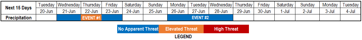
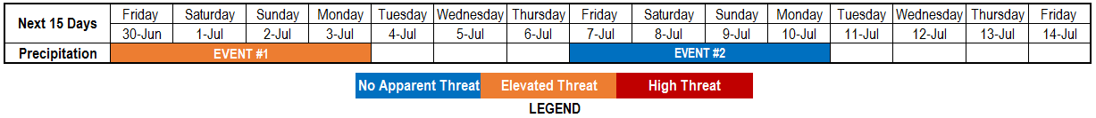
Valid Dates: 6/30 – 7/13
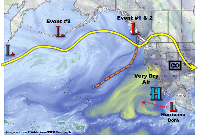
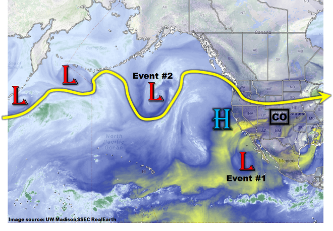
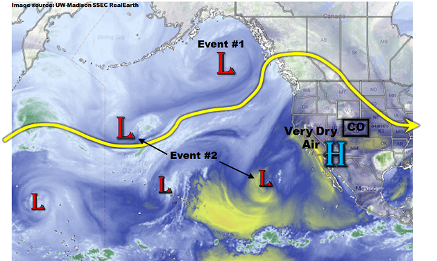
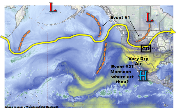
 An active period is in store across mainly eastern Colorado for the Independence Day holiday weekend. As the water vapor image shows, below, a large-scale trough is currently positioned northwest of Colorado. This is bringing a weak cool front southward during the afternoon hours and supporting some isolated to scattered storm activity. As the disturbance slowly moves eastward, return southeasterly flow will quickly regain control of eastern Colorado. This will push moist low-level air into our state, bringing about Event #1. Although we do not expect widespread heavy rainfall or flooding concerns, with the sufficient moisture, storms will have the ability to produce very heavy rainfall. Thus, an elevated flood threat. Just to reiterate: we expect this flood threat to be isolated in area on any given day.
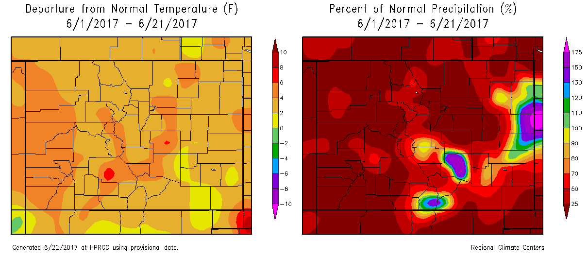
A significant pattern change will occur right around the 4th of July when a strong upper-level ridge (currently off the Baja California coast) begins to dominate the western North American circulation. Initially, it will be sprawled across the entire western U.S., but eventually it will reposition farther north. The prime impact from this type of circulation will be very hot weather with temperatures of 5-10F above average. Yes, this implies a multi-day period of 100F+ temperatures at elevations below 5,000 feet. This is a concern for Colorado’s western slope, which has been hot and dry for weeks, with a prolonged period of elevated fire risk. This will continue for at least another 7-10 days.
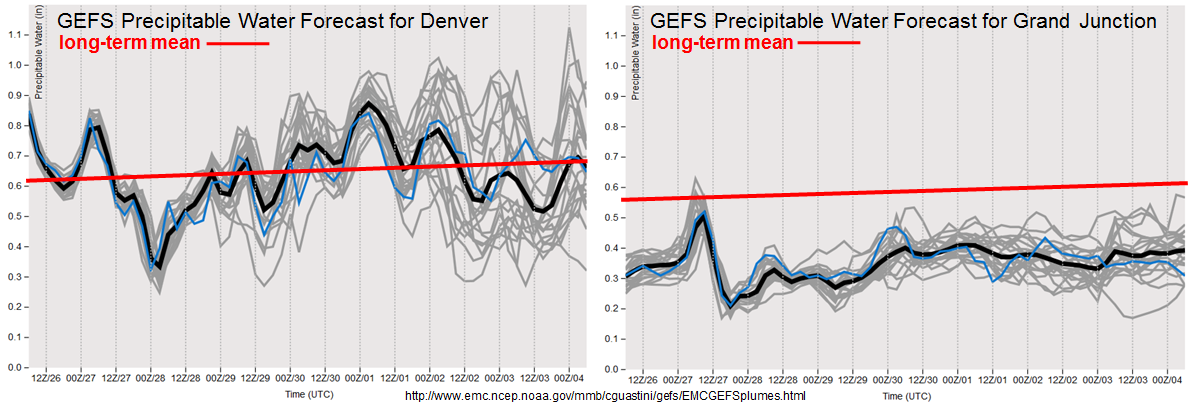
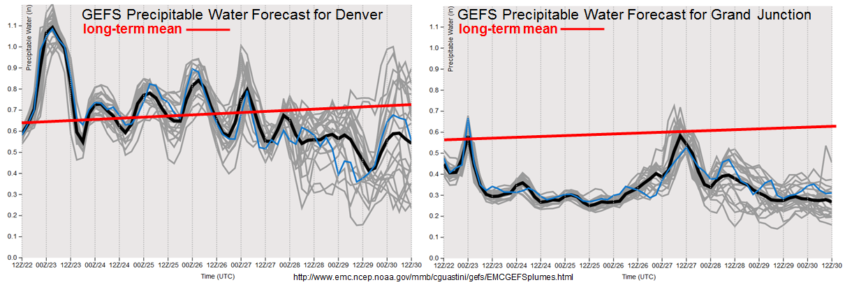
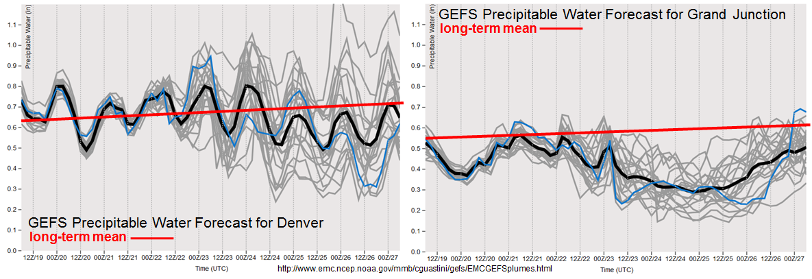
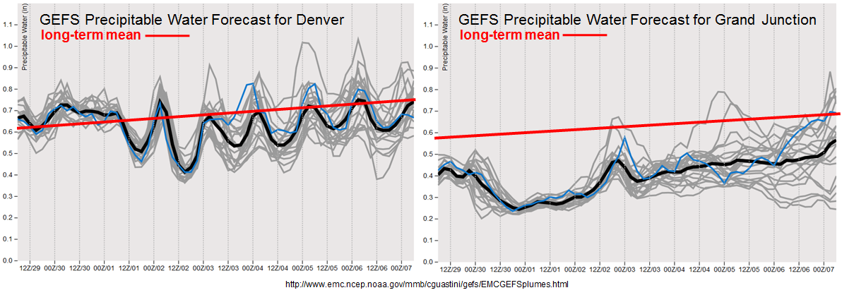
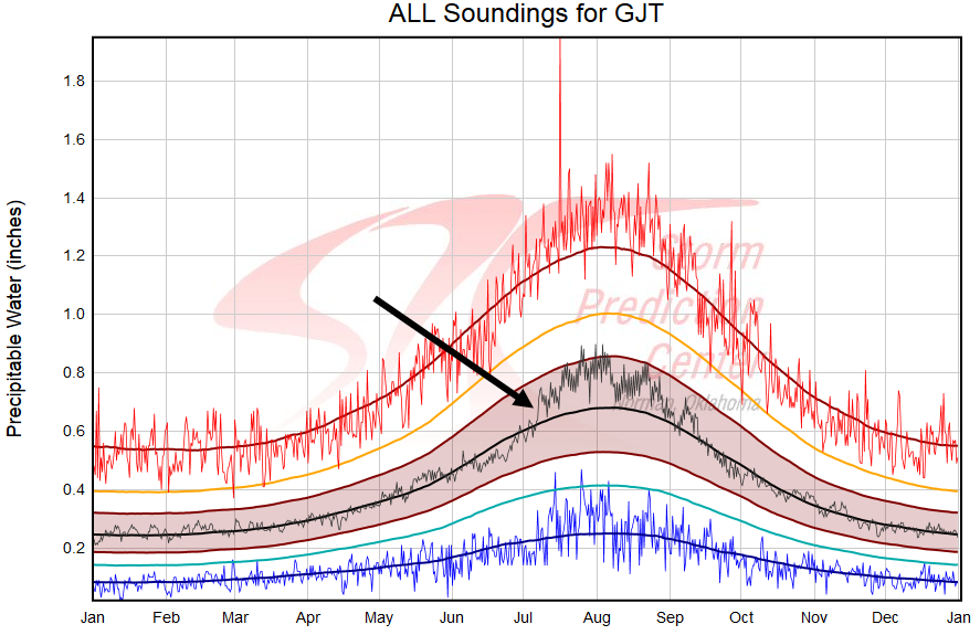
As the high pressure ridge continues to consolidate in a more northward position, this will eventually allow for easterly flow to transport moisture into all of Colorado (not just our eastern half). The forecast Precipitable water plumes, below, show this nicely. Note that at Denver, values stay close to seasonal normal for the next 7-10 days. While at Grand Junction, after an initially very dry atmosphere, there are finally indications of higher moisture after July 4th.
Speaking of higher moisture in western Colorado, as we head into early July, we enter into an interesting period where average moisture tends to jump rather sharply. For example, looking at the climatological Precipitable Water percentiles at Grand Junction (source: Storm Prediction Center), below, note the quick increase in the median value (thin black line) from about 0.6 at the end of June to 0.7 in just a 7-10 day period. These kind of features can often be an important clue and complement to long range weather models.
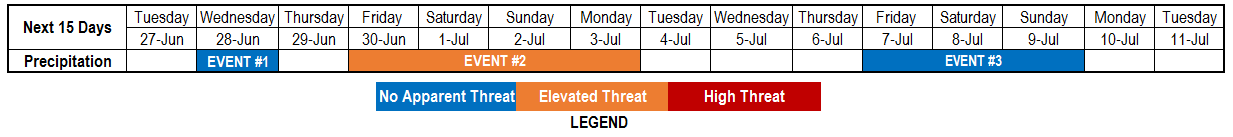
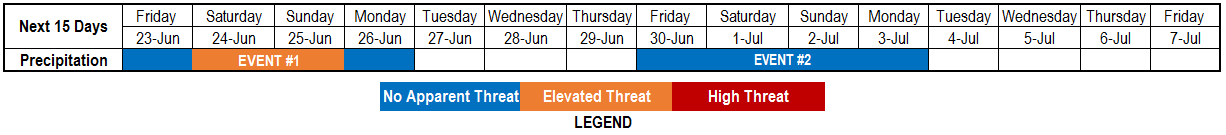
Below we describe each of the two identified precipitation events in more detail.
Event #1: Friday (6/30) through Monday (7/3)
Elevated Flood Threat as at least isolated heavy rainfall is likely during the holiday weekend
Return moisture will begin to advect into Colorado on Friday with scattered showers and thunderstorms likely across the higher terrain east of the Continental Divide as well as the Plains to the east. Isolated heavy rainfall and a flash flood risk (keyword isolated) appear likely. Conditions will continue to support heavy rainfall on Saturday and Sunday when a shortwave embedded in the jet stream will dive southeast and provide favorable upper-level dynamics for large-scale lift across Colorado. West of the Continental Divide, areas will continue to stay too dry to support much, if any rainfall. Instead, a prolonged period of gusty winds could continue to maintain the elevated fire danger. East of the Continental Divide, with sufficient moisture in place, scattered thunderstorms are expected both Saturday and Sunday. Highest coverage will be across eastern areas towards the NE, KS and OK borders where up to 2 inches of rainfall will be possible. Keep in mind, most of this will occur within a few hours on either Saturday or Sunday. Isolated flash flooding appears possible, hence the elevated flood threat. Severe weather, with the main threats being large hail and strong winds, looks to be a threat on Friday and Saturday, then less so by Sunday as shear slackens. By Monday (7/3), more stable air will overtake most of Colorado though residual moisture will likely support another day of isolated to scattered thunderstorms capable of short-term heavy rainfall across the southeast quadrant of the state.
An important heads-up to all campers and hikers: isolated to scattered high elevation storms appear likely during the afternoon hours throughout this stretch. Even if a storm does not cause heavy rainfall, it could still produce hail, lightning and gusty winds. Furthermore, a storm can develop from “nothing” in as little as 20 minutes. Stay alert!

Event #2: Friday (7/7) through Monday (7/10)
No Apparent Flood Threat as monsoon ramp-up still looks on track to graze southwest Colorado
The large scale pattern after Event #1 will feature anomalously high heights over the US Central Plains. In turn, this will promote hot weather across most of Colorado after the 4th of July with temperatures back to being 5-10F above normal. Thereafter, it continues to look like this strong ridge will migrate far enough northward to allow a feed of easterly disturbance that may be the first ramp-up of the 2017 North American monsoon. At this time, and with it being so early in the monsoon season, moisture is a key wildcard and continues to look marginal with Precipitable water staying below 0.75 inches. Nonetheless, with climatology starting to favor diurnal storm activity in the San Juans combined with enough support from long range GFS ensembles, we identify an elevated precipitation threat for southwest Colorado by Friday 7/7. At this time, a flood threat is not anticipated.