Issue Date: Thursday, June 22nd, 2017
Issue Time: 3PM MDT
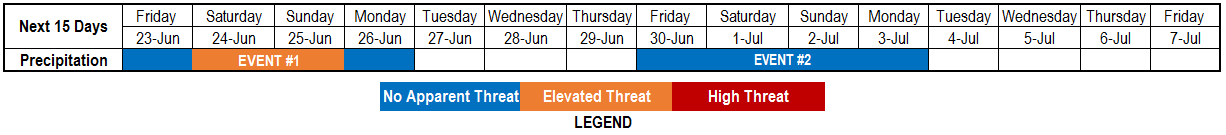
Valid Dates: 6/23 – 7/7
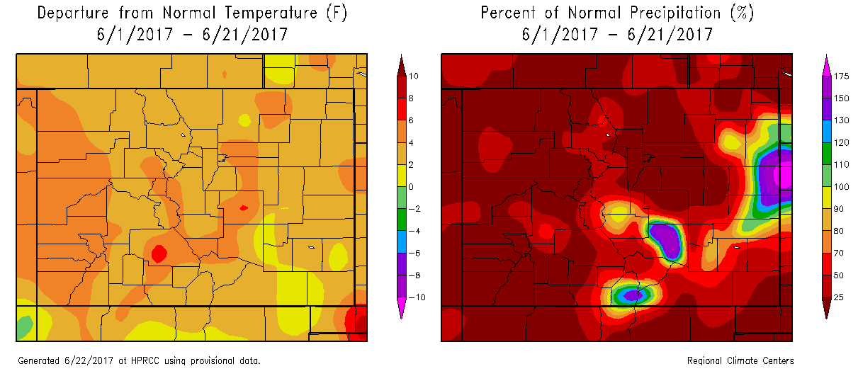
The Continental Divide frequently acts as a meteorological barrier, causing contrasting weather conditions in eastern and western Colorado. June has been a prime example of this, as shown in the temperature and precipitation anomaly maps shown below. While most of the state has been warm this June, generally 2 – 6 degrees F above normal, there has been hardly a drop of rain to the west of the Continental Divide. To be fair, eastern areas have seen streaky rain at best, but that is better than no precipitation at all. One of the key takeaways from this edition of the 15-day Flood Threat Outlook is the continuation of very dry conditions for northwest and western Colorado, raising some concern about the development of a flash drought. Fortunately, water supply appears to be in a stable state, which eases the stress of the lack of rainfall.
This afternoon’s water vapor imagery, below, is a good starting place for the flood outlook. A strong jet is positioned north of Colorado this morning, with a high pressure ridge offshore. A strong Pacific cool front has crossed most of the state providing a cool down and a brief surge of low-level moisture. For most areas, this moisture surge will be temporary, but for southeast Colorado, the front will never make it farther south than the Raton Ridge. Thus, a multiple day period of isolated to scattered thunderstorms is in store, marked as Event #1. This will be further boosted by a disturbance rounding the periphery of the ridge.
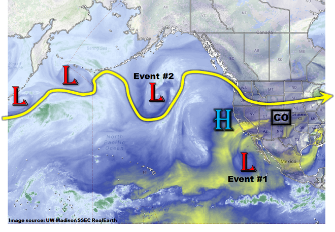
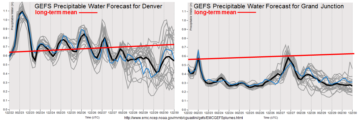
After Event #1, a strong disturbance will enter the US Pacific Northwest coast. This type of entry will initially dry out Colorado with strong westerly winds originating over the Great Basin. This can be seen in the forecasted Precipitable Water plumes, below (note strong drying in both Grand Junction and Denver forecasts). However, the drying will not last long east of the Continental Divide with a weak Atlantic subtropical ridge starting a period of moisture return by Friday, June 30. The result will be a prolonged stretch of at least isolated thunderstorm activity mainly in southeast Colorado, Event #2. Short-term heavy rainfall will be likely, but no organized flood threat is foreseen at this point.
Below we describe each of the two identified precipitation events in more detail.
Event #1: Friday (6/23) through Monday (6/26)
Isolated heavy rainfall, but enough moisture to warrant an Elevated Flood Threat
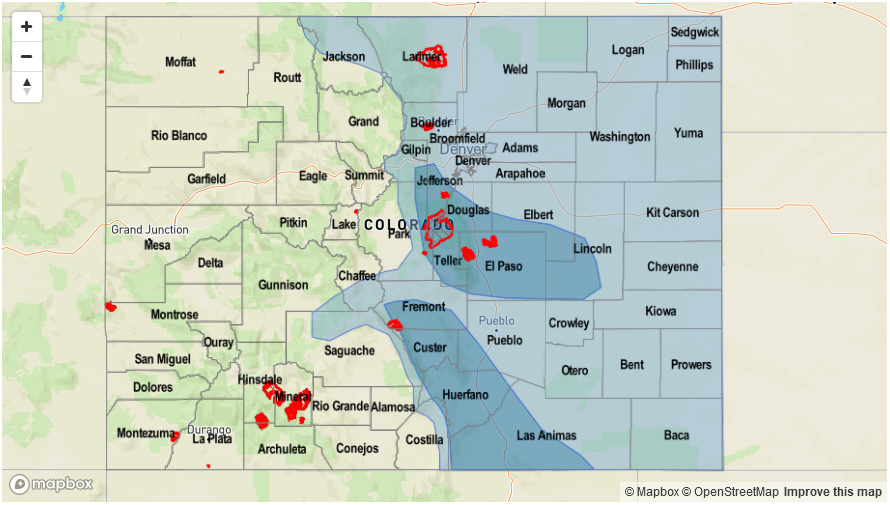
Today’s cool front will stall along the Colorado / New Mexico border. As the surface high pressure (responsible for driving the front south) moves eastward, return moisture will begin to return to mainly southeast Colorado starting Friday and especially by Saturday. With Precipitable water values expected to exceed 1 inch, isolated heavy rainfall will be likely. The most favored region will be the Raton Ridge and Southeast Mountains. The Hayden Pass fire burn area will need to be watched for excessive runoff. Isolated flash flooding, debris slides and mud flows will be possible in the foothills and mountains. Farther northern, storm coverage will be more isolated and rainfall amounts are not expected to exceed 1 inch.

Event #2: Friday (6/30) and Monday (7/3)
No Anticipated Flood Threat as return moisture will fuel daily rounds of popcorn thunderstorms
A ridge will re-establish itself to the west of Colorado, and return moisture will keep the atmosphere unstable during peak heating hours. The result will be daily rounds of isolated to scattered thunderstorm activity, mainly east of the Continental Divide. With slightly above seasonal amounts of low-level moisture, expect short-term heavy rainfall of 15-30 minute duration. Up to 0.75 inches is commonly possible with such storms. However, with little shear in place, storms cannot maintain themselves long. Nonetheless, with an active recreational period in anticipation of July 4th, thunderstorm activity will need to be kept in mind for outdoor plans.