Issue Date: Monday, June 26th, 2017
Issue Time: 2:50PM MDT
Valid Dates: 6/27 – 7/11
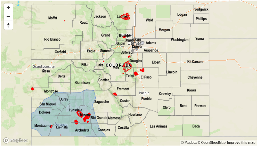
After a roller coaster week featuring near record heat followed by a fall-like cold front, the weather has stabilized across Colorado over the past 48-72 hours. Return flow from the daily lower-level heat low (formed in part due to strong heating with clear mornings) has resulted in daily bouts of isolated to scattered thunderstorm activity, mainly in the southeast part of the state. Over the next 15 days, a variable weather pattern is anticipated, complete with a few frontal passages and associated thunderstorms, intense heat as well as a possible monsoon surge later in the period. Moreover, with Independence Day soon to come, there will be plenty of recreational activity across the state: make sure to check the weather forecast regularly for updates!
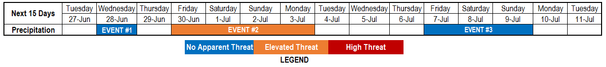
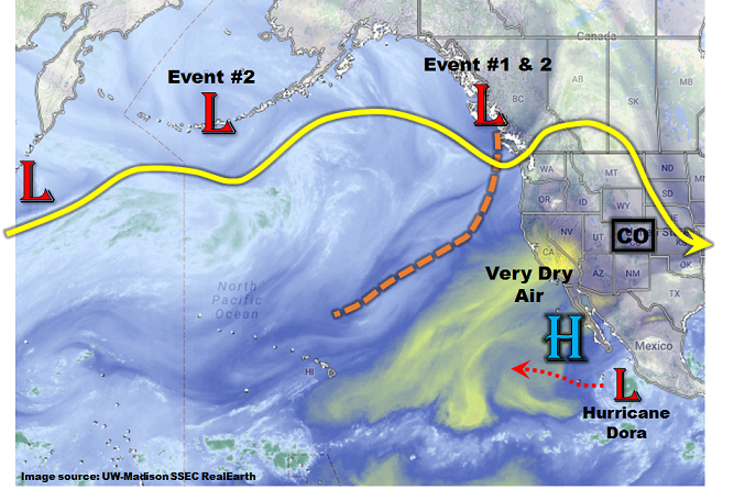
As the water vapor image shows, below, we have identified two precipitation events over the next 7 days. The upper-level ridge will be quickly replaced by a trough as a disturbance crosses into the US west coast. Initially, this disturbance will result in gusty, dry west winds overtaking the state, followed by a cool front passage on Wednesday. The cool front will provide some organized rainfall activity in the far northeast part of the state, but is otherwise unimpressive. Things turn more interesting later this week as another disturbance will quickly enter the US coast and partially combine with the first. A multi-day period of scattered to numerous showers and storms is expected, supporting an elevated flood threat. Fortunately, it appears that July 4th, itself, may be relatively dry as Event #2’s passage ushers in some drier air across most of the state. After Independence Day, guidance suggests a period of very warm/hot weather statewide, which is certainly not good news for the already parched western slope.
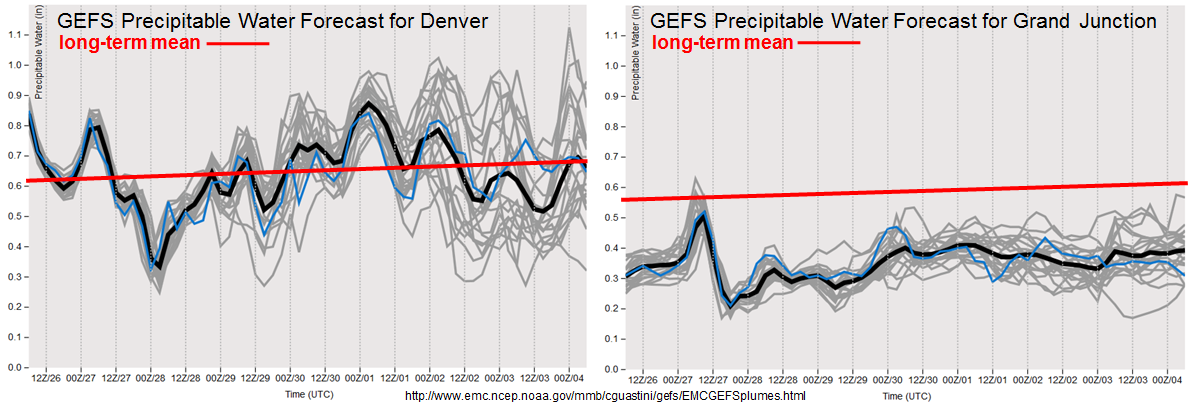
As shown in the forecasted Precipitable Water (PW) plumes from the GFS ensembles, the disparity between eastern and western Colorado will continue in full force. Note that Denver’s PW forecasts are on par, or even slightly above the long-term climatology. Meanwhile, the Grand Junction forecast continues to be well below climatology through the next 7 days. After Independence Day, there is some indication that monsoon moisture will enter southwest Colorado. However, at this lead time, the false alarm rate is high and caution is needed. Nonetheless, there is sufficient confidence to identify a third precipitation Event (#3). However, precipitation coverage and intensity have significant uncertainty.
Below we describe each of the three identified precipitation events in more detail.
Event #1: Wednesday (6/23) through Monday (6/26)
No Apparent Flood Threat as cool front enters the state
A brief window of time on Wednesday afternoon will juxtapose a cool front passage from the north with some elevated moisture content across northeast Colorado. Scattered shower and thunderstorm activity will be possible especially across the Northeast Plains. However, storm motions should be quick enough to limit heavy rainfall to less than 0.5 inches, though localized higher amounts are possible. With a favorable shear profile, severe weather (large hail and gusty winds) will be the bigger threat compared to heavy rainfall. Thereafter, dry, westerly winds overtake most of the state by Thursday.
Event #2: Friday (6/30) through Monday (7/3)
Elevated Flood Threat as another disturbance enters the state right on the heels of Event #1
Return moisture will begin to advect into Colorado on Friday and isolated to scattered thunderstorms will enter the picture in eastern and southeast areas. Things turn more interesting on Saturday and Sunday when a shortwave embedded in the jet stream will dive southeast and provide favorable upper-level dynamics for large-scale lift across Colorado. West of the Continental Divide, areas will simply be too dry to support any heavy rainfall. Instead, a prolonged period of gusty winds could lead to elevated fire danger. However, east of the Continental Divide, with sufficient moisture in place, scattered to numerous thunderstorms are expected both Saturday and Sunday. Highest coverage will be across eastern areas towards the NE and KS borders where up to 2 inches of rainfall will be possible (keep in mind, most of this will occur within a few hours on either Saturday or Sunday). Isolated flash flooding appears possible, hence the elevated flood threat. Severe weather is very likely to be a threat both days as favorable shear and sufficient moisture will overlap. By Monday (7/3), cooler, more stable air will overtake most of Colorado though residual moisture will likely support another day of isolated to scattered thunderstorms capable of short-term heavy rainfall across the Raton Ridge and surrounding plains.

Event #3: Friday (7/7) through Sunday (7/9)
No Apparent Flood Threat as monsoon surge may encroach on southwest Colorado
The large scale pattern after Event #2 will feature anomalously high heights over the US Central Plains. In turn, this will promote very warm to hot weather across most of Colorado after the 4th of July. Thereafter, there are indications that an inverted trough and/or shortwave feature from the west will cause a surge of moisture into the desert southwest. With this kind of lead time, and this early in the monsoon season, moisture is a key wildcard and currently looks marginal at best. Nonetheless, with climatology starting to favor diurnal storm activity in the San Juans combined with enough support from long range GFS ensembles, we identify an elevated precipitation threat for southwest Colorado by Friday 7/7. At this time, a flood threat is not anticipated.