FTO 07-27-2017: Streak Of Heavy Rainfall To Continue, Then Substantial Drying

Issue Date: Thursday, July 27, 2017
Issue Time: 3PM MDT
Valid Dates: 7/28-8/11

If you have ever read either our Flood Threat Bulletin or Flood Threat Outlook discussions, you can probably quickly recall how much emphasis we place in analyzing moisture content when developing the flood threat forecast. The reason for this is that sometimes, especially in the summertime, moisture is as good or better predictor for heavy rainfall that any other guidance, including model Quantitative Precipitation Forecasts! For you technical readers, please refer to this paper in the Monthly Weather Review journal for more information. In short, it is not so much that moisture is a good predictor of where or when thunderstorms will develop, or even how long they last, but it is a good predictor of the upper limit of their potential rain rates.

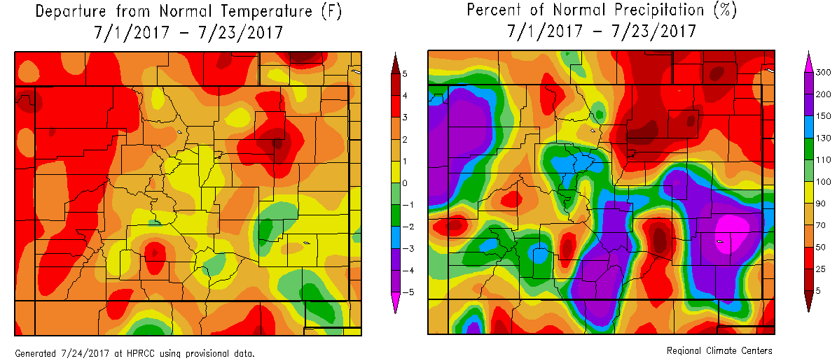
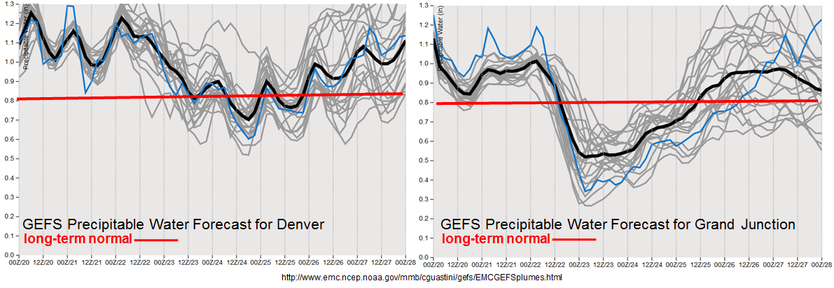
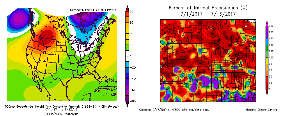
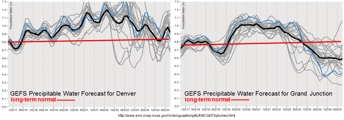
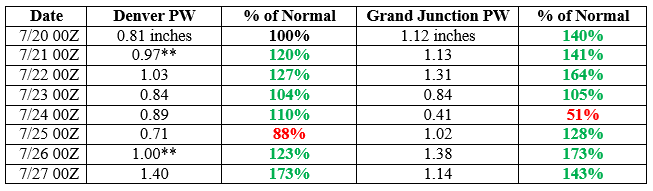
So how has moisture fared across Colorado recently? With little shock, the table below shows significantly above normal amounts over (at least) the past 7 days, as measured by column integrated Precipitable Water at both the Denver and Grand Junction evening soundings (the asterisk in the measurements at Denver signify that the radiosonde did not sample the entire atmosphere, implying that this reading underestimates the actual PW). This was recently punctuated by values over 70% above normal, interestingly coinciding with one of the wettest 48-hour periods observed thus far this summer.

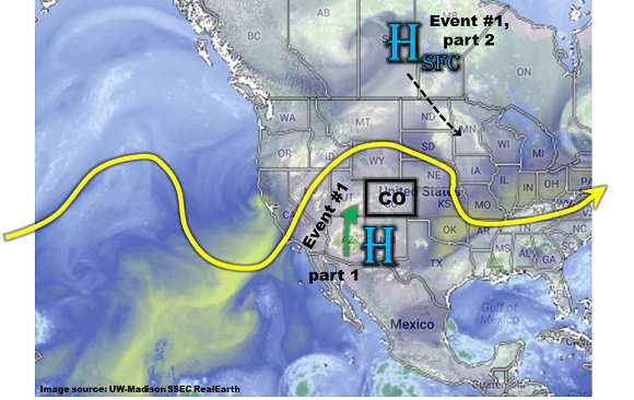
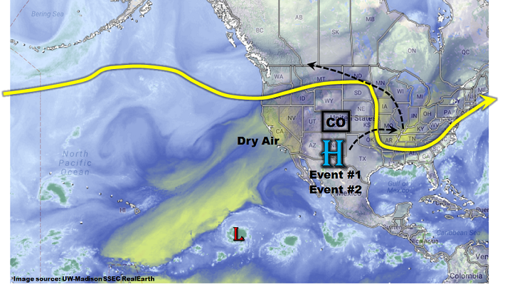
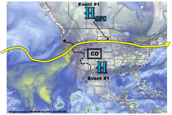
As this afternoon’s water vapor image shows, below, the same familiar players will once again be in charge of flood potential for the next 5 days or so. The first feature is the upper-level ridge that is currently centered just south of Colorado. As long as the western periphery of this ridge does extend too much west of the Four Corners region, this typically allows for the transport of low and mid-level level monsoon moisture into Colorado. This is expected to continue over the next 5 days, keeping elevated moisture and above normal heavy rainfall chances in the picture.

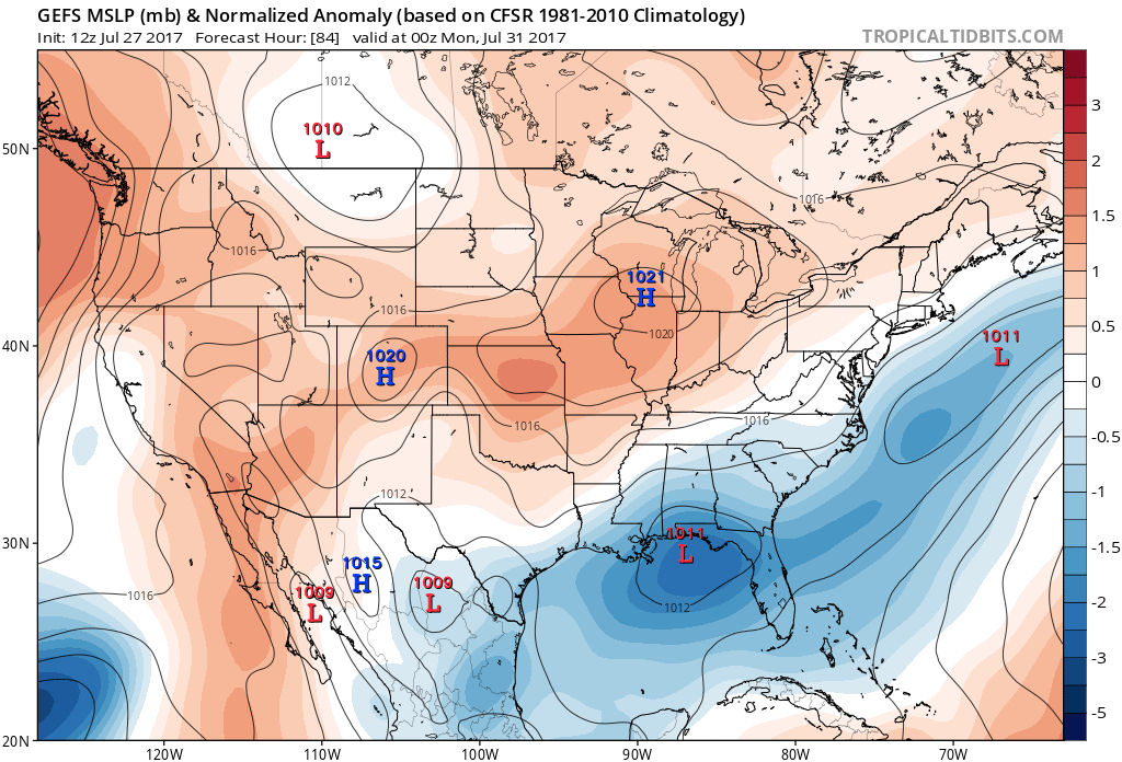
The second, and often overlooked feature, is the presence of surface high pressure features that act to (i) move southward “cool” fronts, especially across eastern Colorado and (ii) more importantly, provide enhanced pulses of moist upslope flow that can interact favorably with the climatological circulation to accentuate and expand the lifetime and eastward extent of the elevated convection over our higher terrain. As shown below in an interesting analysis of surface pressure anomalies available on the Tropical Tidbits model site, another surface high pressure is expected to move southward out of Canada. By Sunday and Monday, a stronger than normal fetch of moist, upslope easterly flow is expected across southeast Colorado. The result will be a pattern conducive for slow moving storms capable of producing very heavy rain rates, much like on Wednesday.

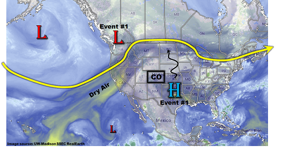
After the passage of this surface high pressure, guidance has now come into good agreement that the upper-level ridge will shift westward, which will drastically reduce moisture levels across most of Colorado. Heavy rainfall and precipitation chances are expected to lessen to below their climatological average accordingly.

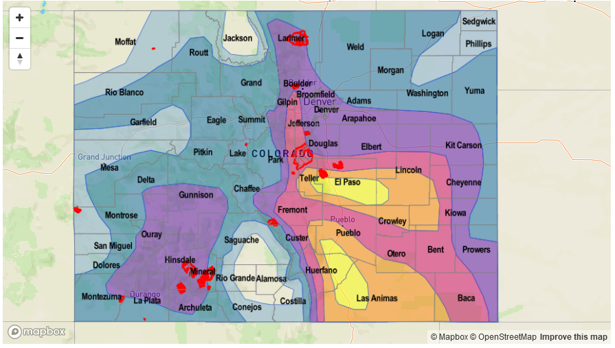
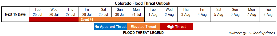
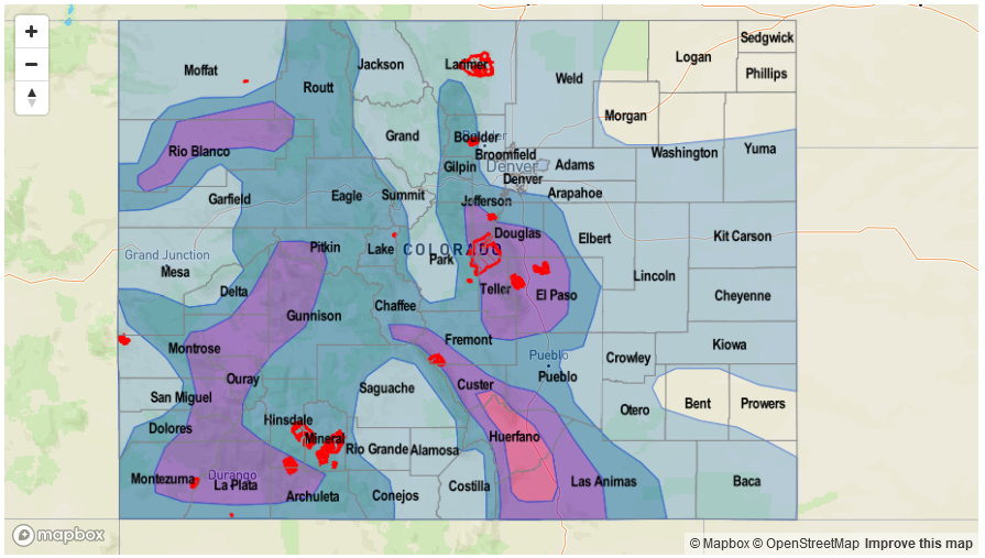
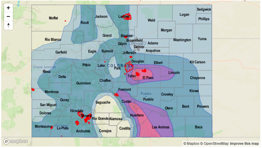
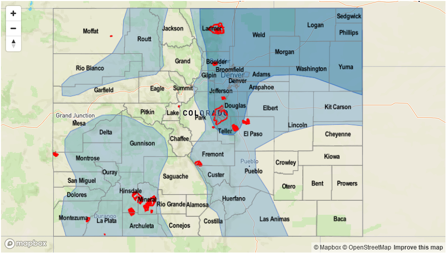
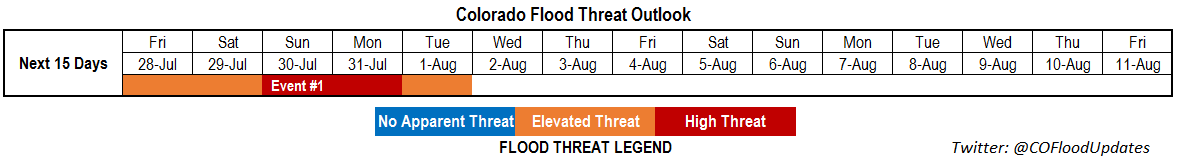
For this edition of the 15-day Flood Threat Outlook, we have identified one prolonged Elevated/High flood threat event that is discussed in more detail below.

Event #1: Friday (7/28) through Tuesday (8/1)

Elevated/High Flood Threat for flash flooding, debris slides and mud flows, especially over higher terrain

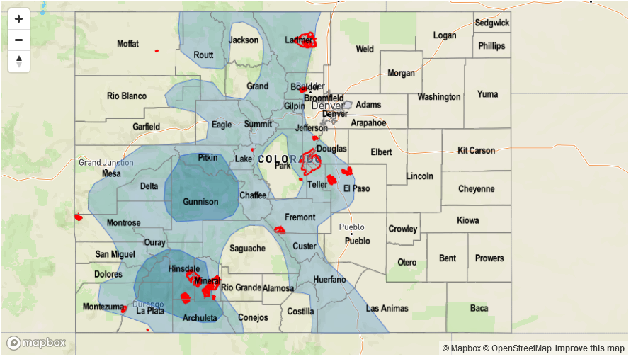
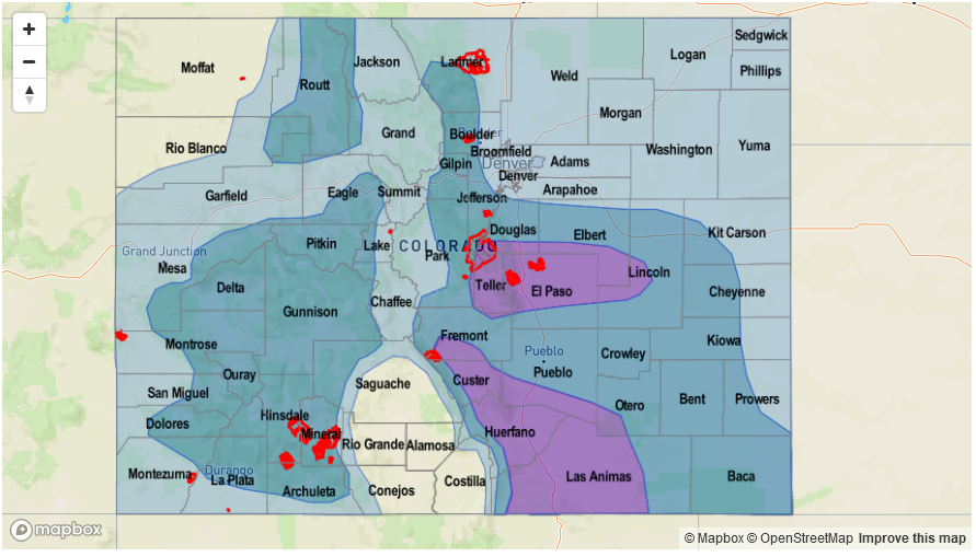
Above normal moisture will persist statewide through early next week. Precipitable water is expected to remain in the 0.9 – 1.6 inch range, which will support daily bouts of scattered to numerous shower and thunderstorm activity from Friday through Tuesday. Rain rates up to 1.4 inches per hour (west) and 2.9 inches per hour (far east) will be possible, which will support an elevated flood threat. Highest coverage will be over the higher terrain, especially east of the Continental Divide as well as southeast Colorado. On Sunday/Monday, a cool front is expected to enhance rainfall coverage over southeast Colorado and amplify the intensity further, sustaining longer duration heavy rainfall. Current guidance suggests 3-hour rainfall up to 4 inches will be possible in the foothills of the Sangre de Cristo and Wet Mountains. Max 3-hour rainfall up to 2.4 inches will be possible in the San Juan Mountains.

As with the recent heavy rainfall event on Wednesday, this event will not have significant upper-level support implying that sustained heavy rainfall, beyond 3 hours, will not be likely. Thus, currently the main impacts of this event will be mud flows and debris slides in higher elevation locations, as well as small stream flooding associated with the stronger cells. Major riverine flooding is not expected at this time. Please stay tuned to daily Flood Threat Bulletins for more detailed information, especially if you plan on camping and hiking over the weekend.

Legend

FTO 07-24-2017: Prolonged Elevated/High Threat Initially Then Pattern Change Possible

Issue Date: Monday, July 24, 2017
Issue Time: 3PM MDT
Valid Dates: 7/25 – 8/8

High moisture content has been a staple across most of Colorado for the past two weeks. The map below shows the composite Precipitable Water (PW) anomaly across the southwest United States over the past 2 weeks, from NOAA ESRL’s excellent composite page. Note the broad positive anomalies (units are kg per square meter…multiply by 0.03937 to get inches), generally equating to anywhere from 10-20% above normal east of the Continental Divide to as much as 30% above normal across far western Colorado. Individual days have seen even higher anomalies.

After a rather dry start to July, rainfall has quickly accumulated across large portions of Colorado. This has not been so much in the form of organized events, as opposed to isolated to scattered storms that produce localized heavy rainfall as they slowly drift along in the weak steering winds. As shown below, this has allowed a large portion of the state to be above average for July precipitation, up to 300% above average in parts of the western slope as well as southeast Colorado. Interestingly, regions north of the Palmer Ridge and northeast Colorado have seen a pronounced minimum in precipitation due to a variety of reasons (which will unfortunately not be discussed here).

As shown in this afternoon’s water vapor image, below, we continue to foresee moisture levels to remain at elevated levels. This is being supported by two main features. First a weak upper-level ridge will provide a south/southwesterly fetch of very high moisture content into western Colorado (a.k.a. monsoon flow). PW values as high as 1.4 inches are expected over the next 48 hours, especially closer to the Utah border. Some of this moisture will be able to make it over the Continental Divide and provide heavy rainfall along the eastern foothills and mountains. In addition, a surface high pressure is expected to move south-southeast out of Canada starting Wednesday. This will deliver a weak cool front across eastern Colorado, providing a focus for thunderstorm activity. As the front slows on its movement southward, plenty of moisture will be available to the daily upslope circulation formed due to our higher terrain. Thus, although we do not foresee an organized flood threat, a High flood threat is in place for the next 72 hours for isolated, but very heavy rainfall capable of causing flash flooding. After this event wanes towards the end of the week, long range guidance is indicating a potential shift to a drier weather pattern. Thus, only one Event is identified for this Outlook. It is described in more detail below.

Event #1: Tuesday (7/25) through Monday (7/31)

High/Elevated Flood Threat for flash flooding, debris slides and mud flows, especially over higher terrain

Significantly above average moisture is expected to hang around Colorado for the next week or so. The original source of the moisture will be via a monsoon surge from the south/southwest. This will allow for daily rounds of shower and thunderstorm activity over the western slope Tuesday and Wednesday. Some of the season’s heaviest rainfall is expected with max 1-hour rainfall up to 1.5 inches and 24-hour totals up to 2.9 inches possible. Isolated flash flooding will be possible, but the bigger threat will be for mud flows and debris slides associated with short-term heavy rainfall as well as in areas with wet soil. The climatologically favored western parts of the San Juans, the Uncompahgre Plateau and the Roan Plateau/Cliffs will be the highest threat areas. However, with moisture at such elevated levels, expected heavy rainfall to make its way all the way down into the lowest valleys. Small stream flooding will be possible with the heaviest rainfall. However, major riverine flooding is not expected.

By Thursday, a surface cool front and surge of moisture is also expected from the northeast as a surface high pressure moves southward out of Canada. With PW up to 1.5 inches (towards the KS border) and up to 1.2 inches even along the foothills, very heavy rainfall will be possible, to the tune of 2.9 inches per hour (east) and 2.1 inches per hour (foothills). The best coverage is expected for the highest terrain of the Palmer and Raton ridges, Sangre de Cristos and Wet Mountains. Isolated flash flooding is expected with the heaviest rainfall. Without organized upper-level forcing, widespread heavy rainfall, and thus major riverine flooding, is not expected though small stream flooding will be likely. However, please check back to daily Flood Threat Bulletins for much more detailed information, since large storm complexes can develop even without substantial upper-level forcing in Colorado.

Legend

FTO 07-20-2017: High Flood Threat Remains In the Forecast For This Weekend

Issue Date: Thursday, July 20, 2017
Issue Time: 3PM MDT
Valid Dates: 7/21 – 8/4

The relatively low-key atmospheric pattern, marked by a near-complete absence of upper-level disturbances, will continue for the next 15 days. Then why, you may ask, have the daily rounds of shower and storm activity, many with heavy rainfall and flooding, been so prevalent especially over the higher terrain? The answer is plentiful moisture. As the water vapor image shows, below, a weak upper-level ridge is positioned southeast of Colorado this afternoon, allowing for a feed of monsoonal moisture into western Colorado. Additionally, periodic surges of very moist air have also made it into eastern Colorado courtesy of cool front passages roughly every 2-4 days. In a nutshell, we expect persistence to this overall pattern, in other words one with a continued lack of upper-level disturbances. The upper-level ridge is expected to stay mostly east of Colorado in the short to medium term, which will allow for continuation of above average, some days significantly so, moisture content. In turn, we expect a continued elevated to high flood threat over the next 7 days, even if the heavy rainfall is isolated in nature.

The anticipated elevated moisture is markedly shown by the forecast Precipitable Water (PW) plumes from today’s GFS ensemble simulations. Note that Denver is forecasted to stay average to above average through the next 8 days. Meanwhile, out west, some drying will follow the latest moisture surge though another surge appears to be on its heels after a 24-36 hour period of drying. Thereafter, there is a weak signal that the high pressure ridge will re-establish west of Colorado, which would effectively decrease the moisture supply. However, too early to speculate that far out, especially during the middle of summer when predictability is lower compared to springtime.

For this Outlook, we have identified two precipitation events, which are described in more detail below.

Event #1: Friday (7/21) through Monday (7/24)

Elevated/High Flood Threat for flash flooding, debris slides and mud flows, especially over higher terrain

Very high moisture content is expected to persist statewide for this event with PW up to 1.1 inches out west and up to 1.5 inches out east. Expect daily rounds of afternoon and evening shower and thunderstorm activity, peaking in coverage on Saturday and Sunday. Max 1-hour rainfall up to 2.7 inches will be possible east of the Continental Divide, and up to 1.3 inches west of the Divide. However, the precipitation will add up and isolated precipitation totals exceeding 3.5 inches (east) and 2.5 inches (west) are very likely by Sunday. Flash flooding, debris slides and mud flows will be likely not only with the heaviest rainfall, but also in soils that have accumulated multiple days’ worth of rainfall (check out our daily Precipitation map product to see regions that have received heavy rainfall). A high flood threat has been posted for Saturday and Sunday due to the expectation of plenty of recreational activity in the higher terrain. Please keep an eye to the sky if you are camping or hiking.

By Monday, expect shower and storm activity to shift southwards towards the Sangre de Cristos and San Juans where heavy rainfall and flooding will still be possible.

Legend

Event #2: Wednesday (7/26) through Friday (7/28)

Elevated Flood Threat as next monsoon surge delivers shot of moist air

After a rather quick lull following Event #1, the next surge of monsoon moisture is expected to enter Colorado from the southwest. Overall, this surge may be overall weaker, and shorter in duration compared to the current surge. Nonetheless, an increase in shower and storm activity will begin by Wednesday, 7/26. At this time, it appears max 1-hour rainfall up to 1.3 inches will be possible out west, which will be enough to cause mud flows and debris slides. Multiple days of rainfall will add to the risk. East of the Continental Divide, confidence in heavy rainfall is lower, but guidance is persuasive enough to warrant precipitation chances in northeast Colorado as the monsoon moisture spills over the Continental Divide. Max 1-hour rainfall up to 2.2 inches will support isolated flash flooding, nuisance urban and field flooding, along with small stream flooding as the main risks. Widespread heavy rainfall is not expected at this time.

Legend

FTO 07-17-2017: Persistent Elevated/High Flood Threat Over The Next Week

Issue Date: Monday, July 17, 2017
Issue Time: 2:10PM MDT
Valid Dates: 7/18 – 8/1

Thus far, July has seen a rather persistent weather pattern marked by a wobbling upper-level ridge anomaly centered north of Colorado. The left map below shows the composite month-to-date 500-mb height anomaly and it is seen that the bullseye of the anomaly is located on the border of Alberta and Montana. The right map below shows month-to-date precipitation anomaly, as a percentage of normal. Generally speaking, wetter than normal conditions have been favored southeast of Colorado with more of both sides of the coin seen for our state. However, a notable exception to this is in southeast Colorado where it has been very wet (up to 250% of normal). One factor that helps explain this is the above normal moisture that has been available for thunderstorm formation, especially in the past 5-7 days.

As shown in the current water vapor image, below, things have changed compared to the maps above. The upper-level ridge has flattened a bit and is now centered south of Colorado. Dry air is found far to the west across California and offshore. Meanwhile, moist air, characterized by Precipitable Water values exceeding 1 inch, continues to hold its fort across eastern, southern and southwestern part of Colorado. Over the next 15-day period covered by this Flood Threat Outlook, the key to our weather pattern will once again come down to determining how the upper-level ridge will be positioned. Current guidance suggests the ridge will first move east of the next 3-5 days, followed by a gradual retraction back to the northwest, to be in a position reminiscent of that observed during the first half of July. Importantly, the temporary shift of the ridge to the east will allow for an effective return of both moisture and upper-level dynamics into Colorado.

We have identified two organized precipitation events, which together span the first 6 days of this Outlook. The first event will be the result of elevated moisture levels that will produce isolated heavy rainfall mainly over the higher elevations. The second event is a more organized stretch of heavy rainfall potential as a monsoon moisture surge moves north/northeast into Colorado, along with a cool front expected to cross the eastern half of the state. As shown in the forecasted PW plumes for Denver and Grand Junction, both locations will experience generally above or even significantly above moisture content through early next week, which is conducive to heavy rainfall in Colorado. Below each event is described in more detail.

Event #1: Tuesday (7/18) and Wednesday (7/19)

Elevated Flood Threat for isolated higher-elevation heavy rainfall

Above average moisture will continue to maintain a presence over most of Colorado for this event with Precipitable Water values in the 0.75 to 1 inch range statewide. With clear skies in the morning, expect early shower and thunderstorm activity to form across the entire high country, with the highest intensity and coverage over southern areas. Brief heavy rainfall, up to 0.5 inches in 30 minutes will be common, and some locations will experience several rounds of such storms from the later morning through the early evening hours. By later in the afternoon, the merging of storm outflow boundaries will maintain the potential for heavier rainfall, up to 1.2 inches in 1 hour. This will be capable of causing isolated mud flows, debris slides and flash flooding especially over steeper terrain where less rain is needed to cause problems.

Legend

Event #2: Thursday (7/20) through Monday (7/24)

Prolonged Elevated/High Flood Threat statewide with monsoon surge (west) and cool front (east) acting as forcing

As hinted by the forecasted PW plumes (see above), higher moisture is expected to arrive into Colorado from the southwest by Thursday, 7/20. PW values are expected to exceed 1.0 inch across most of the state with localized readings up to 1.2 inches (west) and 1.5 inches (east). On Thursday and Friday, scattered to numerous thunderstorm activity is expected for the western slope and Continental Divide. These storms will be capable of producing 0.8 inches of rain in 30 minutes. However, up to 2.0 inches will be possible over a 24 hour period. Mud flows and debris slides will become a bigger impact by Friday, especially over regions that experience consecutive days of heavy rainfall.

By Saturday and Sunday, attention turns east of the Divide as an expected cool front will provide a focal point for storm activity. With relatively weak wind shear expected, relatively brief heavy rainfall is expected. However, with plenty of moisture available, up to 1.8 inches in 30 minutes and 2.7 inches in 1 hour will be possible. Isolated flash flooding appears likely, especially over the sensitive newer burn scars. By later in the event, antecedent wet soils will also contribute to an increased runoff risk. It is possible that event will be upgraded to a High threat by the next Outlook. The day by day features will be described in much more detail in the Flood Threat Bulletins, so stay tuned.

Legend