Issue Date: Monday, July 24, 2017
Issue Time: 3PM MDT
Valid Dates: 7/25 – 8/8
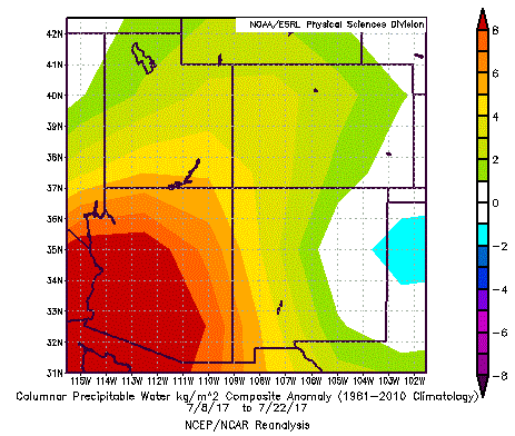
 High moisture content has been a staple across most of Colorado for the past two weeks. The map below shows the composite Precipitable Water (PW) anomaly across the southwest United States over the past 2 weeks, from NOAA ESRL’s excellent composite page. Note the broad positive anomalies (units are kg per square meter…multiply by 0.03937 to get inches), generally equating to anywhere from 10-20% above normal east of the Continental Divide to as much as 30% above normal across far western Colorado. Individual days have seen even higher anomalies.
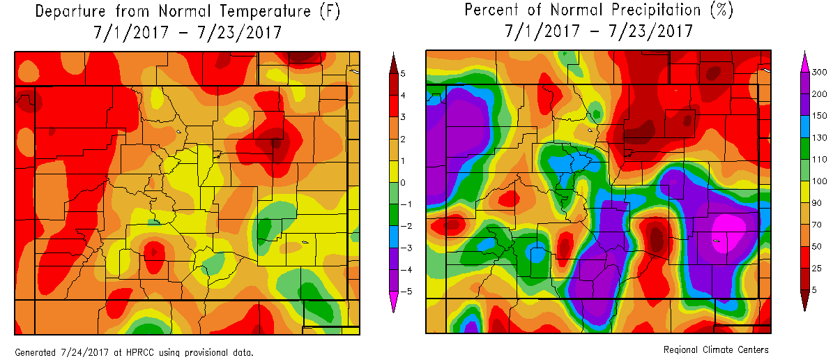
After a rather dry start to July, rainfall has quickly accumulated across large portions of Colorado. This has not been so much in the form of organized events, as opposed to isolated to scattered storms that produce localized heavy rainfall as they slowly drift along in the weak steering winds. As shown below, this has allowed a large portion of the state to be above average for July precipitation, up to 300% above average in parts of the western slope as well as southeast Colorado. Interestingly, regions north of the Palmer Ridge and northeast Colorado have seen a pronounced minimum in precipitation due to a variety of reasons (which will unfortunately not be discussed here).
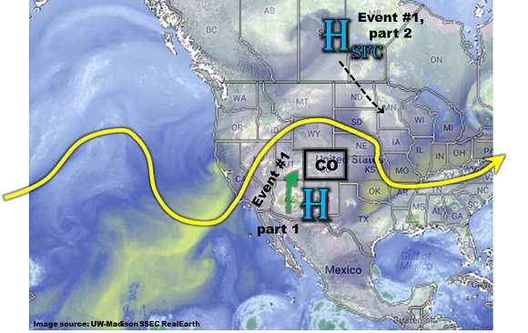
As shown in this afternoon’s water vapor image, below, we continue to foresee moisture levels to remain at elevated levels. This is being supported by two main features. First a weak upper-level ridge will provide a south/southwesterly fetch of very high moisture content into western Colorado (a.k.a. monsoon flow). PW values as high as 1.4 inches are expected over the next 48 hours, especially closer to the Utah border. Some of this moisture will be able to make it over the Continental Divide and provide heavy rainfall along the eastern foothills and mountains. In addition, a surface high pressure is expected to move south-southeast out of Canada starting Wednesday. This will deliver a weak cool front across eastern Colorado, providing a focus for thunderstorm activity. As the front slows on its movement southward, plenty of moisture will be available to the daily upslope circulation formed due to our higher terrain. Thus, although we do not foresee an organized flood threat, a High flood threat is in place for the next 72 hours for isolated, but very heavy rainfall capable of causing flash flooding. After this event wanes towards the end of the week, long range guidance is indicating a potential shift to a drier weather pattern. Thus, only one Event is identified for this Outlook. It is described in more detail below.
Event #1: Tuesday (7/25) through Monday (7/31)
High/Elevated Flood Threat for flash flooding, debris slides and mud flows, especially over higher terrain
Significantly above average moisture is expected to hang around Colorado for the next week or so. The original source of the moisture will be via a monsoon surge from the south/southwest. This will allow for daily rounds of shower and thunderstorm activity over the western slope Tuesday and Wednesday. Some of the season’s heaviest rainfall is expected with max 1-hour rainfall up to 1.5 inches and 24-hour totals up to 2.9 inches possible. Isolated flash flooding will be possible, but the bigger threat will be for mud flows and debris slides associated with short-term heavy rainfall as well as in areas with wet soil. The climatologically favored western parts of the San Juans, the Uncompahgre Plateau and the Roan Plateau/Cliffs will be the highest threat areas. However, with moisture at such elevated levels, expected heavy rainfall to make its way all the way down into the lowest valleys. Small stream flooding will be possible with the heaviest rainfall. However, major riverine flooding is not expected.
By Thursday, a surface cool front and surge of moisture is also expected from the northeast as a surface high pressure moves southward out of Canada. With PW up to 1.5 inches (towards the KS border) and up to 1.2 inches even along the foothills, very heavy rainfall will be possible, to the tune of 2.9 inches per hour (east) and 2.1 inches per hour (foothills). The best coverage is expected for the highest terrain of the Palmer and Raton ridges, Sangre de Cristos and Wet Mountains. Isolated flash flooding is expected with the heaviest rainfall. Without organized upper-level forcing, widespread heavy rainfall, and thus major riverine flooding, is not expected though small stream flooding will be likely. However, please check back to daily Flood Threat Bulletins for much more detailed information, since large storm complexes can develop even without substantial upper-level forcing in Colorado.