Issue Date: Thursday, July 20, 2017
Issue Time: 3PM MDT
Valid Dates: 7/21 – 8/4

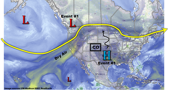
The relatively low-key atmospheric pattern, marked by a near-complete absence of upper-level disturbances, will continue for the next 15 days. Then why, you may ask, have the daily rounds of shower and storm activity, many with heavy rainfall and flooding, been so prevalent especially over the higher terrain? The answer is plentiful moisture. As the water vapor image shows, below, a weak upper-level ridge is positioned southeast of Colorado this afternoon, allowing for a feed of monsoonal moisture into western Colorado. Additionally, periodic surges of very moist air have also made it into eastern Colorado courtesy of cool front passages roughly every 2-4 days. In a nutshell, we expect persistence to this overall pattern, in other words one with a continued lack of upper-level disturbances. The upper-level ridge is expected to stay mostly east of Colorado in the short to medium term, which will allow for continuation of above average, some days significantly so, moisture content. In turn, we expect a continued elevated to high flood threat over the next 7 days, even if the heavy rainfall is isolated in nature.
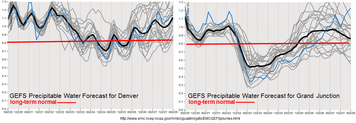
The anticipated elevated moisture is markedly shown by the forecast Precipitable Water (PW) plumes from today’s GFS ensemble simulations. Note that Denver is forecasted to stay average to above average through the next 8 days. Meanwhile, out west, some drying will follow the latest moisture surge though another surge appears to be on its heels after a 24-36 hour period of drying. Thereafter, there is a weak signal that the high pressure ridge will re-establish west of Colorado, which would effectively decrease the moisture supply. However, too early to speculate that far out, especially during the middle of summer when predictability is lower compared to springtime.
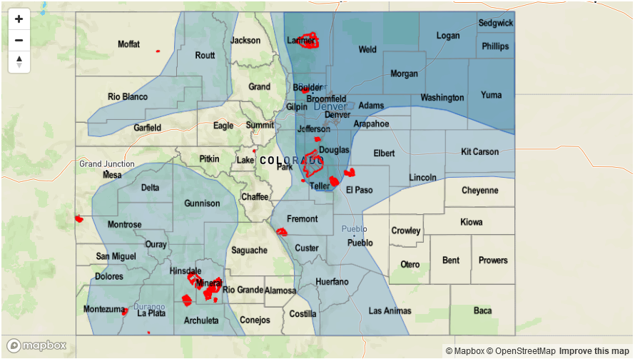
For this Outlook, we have identified two precipitation events, which are described in more detail below.
Event #1: Friday (7/21) through Monday (7/24)
Elevated/High Flood Threat for flash flooding, debris slides and mud flows, especially over higher terrain
Very high moisture content is expected to persist statewide for this event with PW up to 1.1 inches out west and up to 1.5 inches out east. Expect daily rounds of afternoon and evening shower and thunderstorm activity, peaking in coverage on Saturday and Sunday. Max 1-hour rainfall up to 2.7 inches will be possible east of the Continental Divide, and up to 1.3 inches west of the Divide. However, the precipitation will add up and isolated precipitation totals exceeding 3.5 inches (east) and 2.5 inches (west) are very likely by Sunday. Flash flooding, debris slides and mud flows will be likely not only with the heaviest rainfall, but also in soils that have accumulated multiple days’ worth of rainfall (check out our daily Precipitation map product to see regions that have received heavy rainfall). A high flood threat has been posted for Saturday and Sunday due to the expectation of plenty of recreational activity in the higher terrain. Please keep an eye to the sky if you are camping or hiking.
By Monday, expect shower and storm activity to shift southwards towards the Sangre de Cristos and San Juans where heavy rainfall and flooding will still be possible.
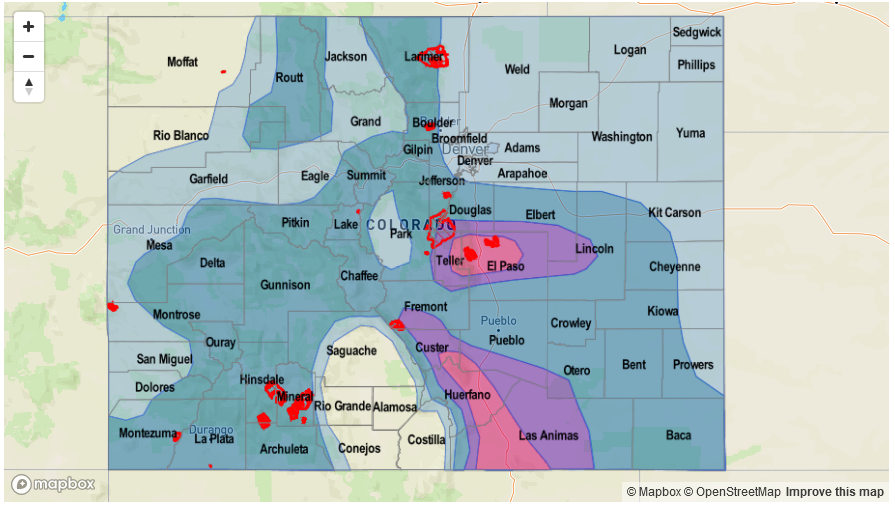

Event #2: Wednesday (7/26) through Friday (7/28)
Elevated Flood Threat as next monsoon surge delivers shot of moist air
After a rather quick lull following Event #1, the next surge of monsoon moisture is expected to enter Colorado from the southwest. Overall, this surge may be overall weaker, and shorter in duration compared to the current surge. Nonetheless, an increase in shower and storm activity will begin by Wednesday, 7/26. At this time, it appears max 1-hour rainfall up to 1.3 inches will be possible out west, which will be enough to cause mud flows and debris slides. Multiple days of rainfall will add to the risk. East of the Continental Divide, confidence in heavy rainfall is lower, but guidance is persuasive enough to warrant precipitation chances in northeast Colorado as the monsoon moisture spills over the Continental Divide. Max 1-hour rainfall up to 2.2 inches will support isolated flash flooding, nuisance urban and field flooding, along with small stream flooding as the main risks. Widespread heavy rainfall is not expected at this time.