FTO 08-24-2017: Several Rainfall Events, One With A Brief Low-End Flood Threat

Issue Date: Thursday, August 24, 2017
Issue Time: 2PM MDT
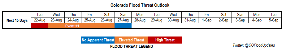
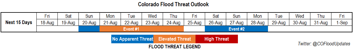
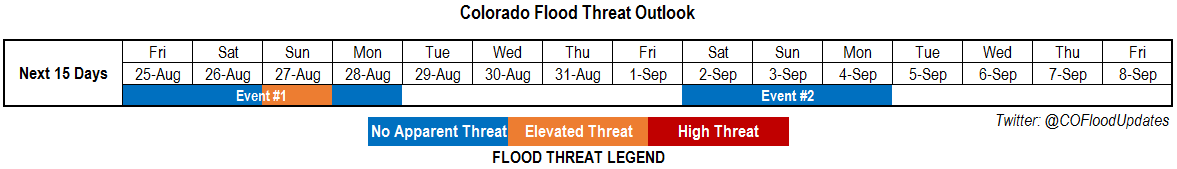
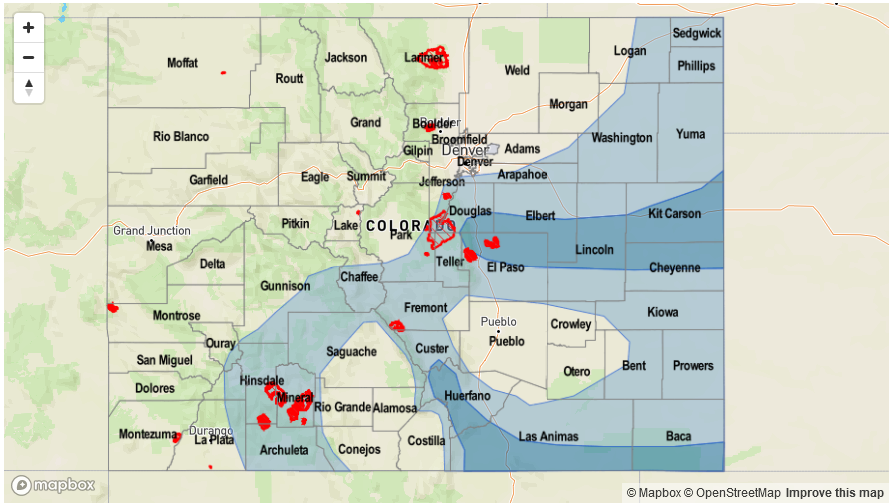
Valid Dates: 8/25-9/8

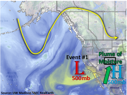
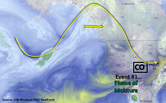
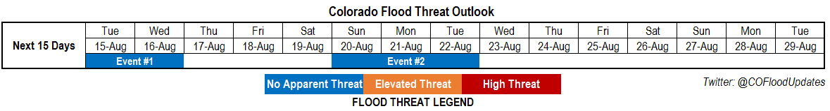
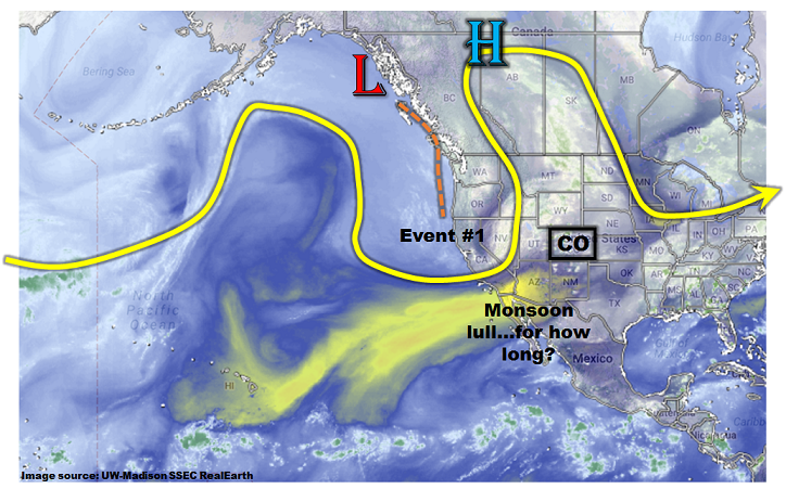
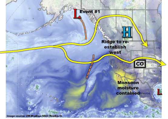
This afternoon’s water vapor imagery, below, shows a rather busy atmospheric pattern over the eastern North Pacific Ocean and western North American continent. A weak upper-level ridge was positioned over Alberta with an undercutting jet stream to the south. Within this jet, several weak disturbances were noted, causing large-scale upward motion. As we move into the next 72-96 hours, these features will trek across Colorado, providing enhanced periods of generally light to moderate rainfall. The exception will be on Sunday, as a surface high pressure system is expected to drop south out of Canada, helping drive a cool front southward across eastern Colorado. A brief period of heavier rainfall will be possible, warranting an Elevated flood threat on Sunday afternoon and evening.

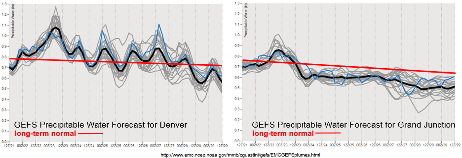
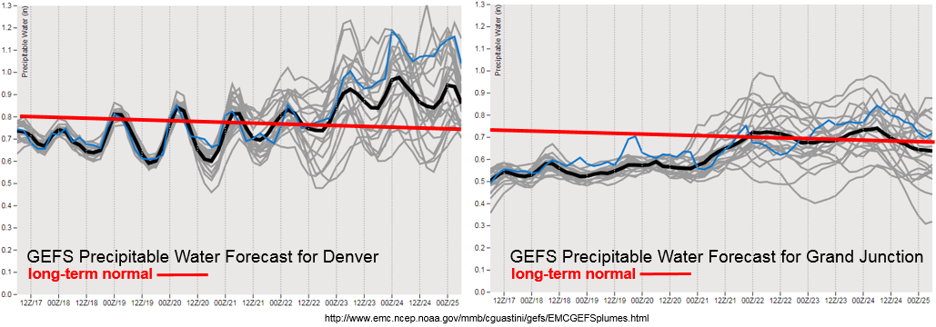
After Event #1, drier conditions are expected statewide as an upper-level ridge rebuilds to the northwest of Colorado. With a maintenance of average to above average Precipitation Water (PW; see GFS ensemble plume forecasts below), isolated showers and weak thunderstorms will be possible during the afternoons but the coverage and intensity appear to be too marginal to designate this as an individual precipitation “Event”. However, by Saturday, 9/2, guidance is in reasonable agreement that a strong surface high pressure will move southward into the Great Plains out of Canada. This late in the season, it is uncertain whether there will be enough low-level moisture available for heavy rainfall, with even more uncertainty due to the presence of Hurricane Harvey in the Gulf of Mexico. However, we have labeled this as Event #2 due to an expected increase in precipitation coverage.

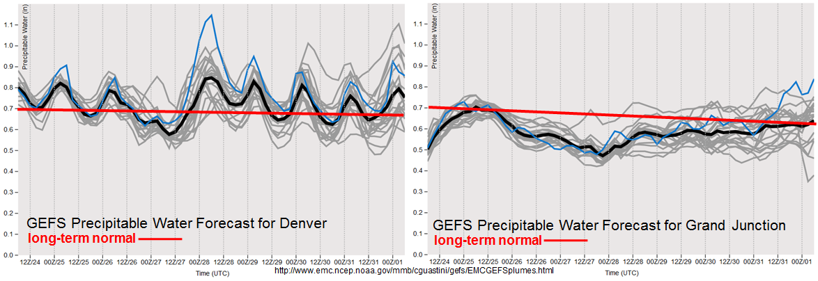
As shown in the forecasted PW plumes, above, most of the precipitation “action” during the Outlook is expected to stay east of the Continental Divide as monsoon moisture should remain bottled up in Arizona and New Mexico.

Below we describe each of the two identified precipitation events in more detail.

Event #1: Friday (8/25) through Monday (8/28)

Low-end Elevated flood threat on Sunday in between a period of light/moderate rainfall

Several upper-level disturbances are expected to trek eastward across Colorado through next Monday. Most of these will be strictly upper-level driven, and with only marginal boundary layer moisture/convergence are not expected to produce heavy rainfall. Instead, light to moderate rainfall up to 0.75 inches will be possible during Friday and Saturday afternoons east of the Continental Divide. On Sunday, a frontal passage is expected across eastern Colorado. With PW expected to be at or above 1 inch across eastern Colorado, localized heavy rainfall rates up to 1.5 inches per hour will be possible. An accompanying isolated flash flood and small stream flood risk will be present with the strongest thunderstorms. However, riverine flooding is not expected. Marginally severe thunderstorms (main impact: large hail) will be possible especially eastward towards the KS border.

By Monday, drier air will overtake most of the state though showers and weak thunderstorms will be possible over southeast Colorado.

Legend

Event #2: Sunday (9/2) through Monday (9/4)

No Apparent Flood Threat as front passage likely, but moisture availability uncertain

Guidance is in good agreement that a relatively strong surface high pressure will move southward out of Canada, driving a cool front passage across eastern Colorado. A period of enhanced rainfall coverage is expected starting Saturday, 9/2. At this time, rainfall rates are not expected to exceed 0.5 inches per day, thus no precipitation map is provided. Depending on what transpires in the Gulf of Mexico with Hurricane Harvey, it is possible that more moisture will be available to draw into Colorado, which in turn could elevate the flood threat. Check back to Monday’s Outlook for more information.

FTO 08-21-2017: Moisture Plume Returns and Increases the Flood Threat

Issue Date: Monday, August 21, 2017
Issue Time: 3PM MDT
Valid Dates: 8/22-9/5

As seen on the water vapor image below, a strong upper-level ridge resides over the Pacific Northwest. At 500mb there is also a Low pressure system off the coast of southern California. With a broad area of higher pressure aloft over Texas, the gradient between the Low and High pressure has advected a plume of monsoon moisture into the state. With slow and variable steering winds aloft under the ridge, the increase in moisture has brought a High Flood Threat to Colorado tomorrow and an Elevated Flood Threat through Saturday.

Below are the forecasted Precipitable Water (PW) plumes for Denver and Grand Junction. The PW began to increase Sunday afternoon, but is expected to peak Tuesday evening. PW will be higher than the long-term normal at both locations and could reach as high as 1.3 inches over SE Colorado. This setup is similar to the active period at the end of July, except no mid-level high pressure is well-defined over Texas during the full period. This may limit the intensity of the moisture advection and confine the higher moisture to southern Colorado and the eastern plains. The surge of moisture, and antecedent atmospheric moisture, hangs around through Sunday evening. The extended period of active weather has been labeled as Event #1.

On Thursday, the upper-level low pressure system begins to move eastward. With the elevated moisture in the atmosphere, this extra energy could support stronger storms and widespread rainfall over the eastern plains. There is enough confidence to identify this period as an elevated threat, although the full details of this event are still developing. Please check back to the daily Flood Threat Bulletin for more detail.

Below we describe Event #1 in more detail.

Event #1: Tuesday (8/22) through Sunday (8/27)

High/Elevated Flood Threat as monsoon moisture plume creates daily rounds of heavy rainfall.

A plume of monsoon moisture continues to make its way into Colorado peaking Tuesday evening. A mid-level Low/High pressure gradient has created a strong southerly component to the flow that is advecting moisture into Colorado. Short-term heavy rainfall will be likely over the climatologically favored regions of southwestern Colorado, Southeast Mountains and Palmer Ridge daily throughout this week. On Thursday, the mid-level Low pressure system will move through Colorado and is expected to produce another round of heavy precipitation that could last into the overnight hours. Max 1-hour rainfall rates greater than 1.5 inches (east) and 1.0 (west) are expected tomorrow afternoon and evening. With slow steering winds under the ridge and elevated moisture, it is likely max 1-hour rain rates could exceed those same thresholds throughout the week. Threats include flash flooding as well as debris slides and mud flows over the higher terrains and susceptible burn scars. Multiple rounds of rainfall will also increase these threats as the soil becomes saturated towards the end of the week.

Legend

FTO 08-17-2017: Return Of Monsoon Surge And Heavy Rainfall

Issue Date: Thursday, August 17, 2017
Issue Time: 3PM MDT
Valid Dates: 8/18-9/1

After a very short break, a more active weather pattern is on its way to Colorado once again. As seen on the water vapor image, below, a strong upper-level ridging pattern will establish itself north of Colorado over next couple of days. A mid-level trough will also separate from the main flow and set up over Southern California early next week. With a secondary upper-level high pressure ridge over eastern Texas and the trough over southern CA, a plume of monsoon moisture will start to be pulled into the state. The low-level moisture combined with slow steering winds under the ridge will bring an elevated flood threat to Colorado starting at the beginning of next week.

As shown in the forecasted Precipitable Water (PW) plumes below, the moistening begins in earnest on Monday for both Denver and Grand Junction. The higher PW on both sides of the Continental Divide is expected to reach its maximum in the middle of next week. PW could reach as high as 1-1.4 inches statewide, but there is still quite a bit of uncertainty regarding just how high PW will get at this point. The overall setup is similar to our past few weeks, which was a very active period statewide. The details of when all the ingredients will come together for the best flood threat is still a bit uncertain, but there is sufficient confidence of an active weather pattern, and associated elevated flood threat, starting next week. We have labeled this prolonged period of active weather as Event #1.

Looking farther out, it is possible that the active pattern will continue. Guidance suggests a possible maintenance of elevated moisture, though generally confined to the eastern half of the state. This will coincide with a northwesterly flow aloft, allowing for the passage of several shortwave disturbances. There is enough confidence to identify this period as Event #2  but not enough confidence to warrant an elevated flood threat.

Below we describe each of the two identified precipitation events in more detail.

Event #1: Sunday (8/21) through Thursday (8/24)

Elevated Flood Threat as monsoon moisture plume returns under the ridge

A mid-level trough will work its way down to southern California while the ridge rebuilds over Colorado. A high pressure will set up over Texas. A strong southerly component of the flow from the trough/ridge gradient will advect a plume of elevated moisture over the state. Short-term heavy rainfall will be likely both over southwestern Colorado and the eastern mountains and plains (though coverage is uncertain). Intensities of up to 1 inch per hour (west) and 1.5 inch per hour (east) are likely, which is high enough for flash flooding as well as debris slides and mud flows over the higher terrain. The multi-day nature of the event implies saturated soils will become of increasing concern in increasing runoff towards the latter part of the event. Stay tuned to next Monday’s Flood Threat Outlook for an update.

Legend

Event #2: Saturday (8/26) through Monday (8/28)

No Apparent Flood Threat at this time, though elevated moisture may remain in eastern Colorado

A ridging pattern will continue its hold over Colorado with the surface high over northeastern Texas. The position of the surface high is expected to bring southerly winds, and increased low-level moisture, to eastern Colorado. Current guidance suggests PW up to 1.1 inches over the eastern plains, translating to hourly rain rates that may exceed 1.5 inches. Although there is not enough confidence to warrant an elevated threat at this time, a low flood threat could arise for the climatologically favored portions of the Southeast Mountains, Raton Ridge and Palmer Ridge.

Legend

FTO 08-14-2017: Drying Persists In The Short-Term, But Possible Monsoon Surge Next Week

Issue Date: Monday, August 14, 2017
Issue Time: 3PM MDT
Valid Dates: 8/15-8/29

As shown in the water vapor image, below, a dynamic “high-amplitude” pattern is currently found across the eastern North Pacific and western parts of North America. A strong low-pressure trough is currently entering the US west coast, supported mainly by the jet stream though moisture return is not all that impressive. As this disturbances makes it to Colorado, we expect an increase in shower and thunderstorm coverage over the next 48 hours. However, with fast steering winds, and marginal low-level moisture, flooding is not currently expected with this event (Event #1).

Thereafter, large-scale drying is expected as a more zonal flow brings in drier air from the west. As shown in the forecasted Precipitable Water (PW) plumes, below, this drying will be more marked west of the Continental Divide. For example, Grand Junction’s PW is forecasted to dip as low as 0.4 inches by Thursday 8/17, which is substantially below normal. East of the Continental Divide, moisture as measured by the entire atmospheric column will be close to seasonal averages, but persistent and modestly strong westerly steering winds will provide for general downsloping (drying) conditions, limiting heavy rainfall chances and actually precipitation, in general.

Looking farther out, given that we are still in the midst of the monsoon season, it is no surprise to see guidance suggesting the development of another large-scale moisture surge by early next week. At this time, this surge appears to be too brief in duration, with only marginal moisture. Thus, we label it as Event #2, but no flood threat is currently foreseen.

Each of the two identified events are described in more detail below.

Event #1: Tuesday (8/15) and Wednesday (8/16)

No Apparent Flood Threat but scattered to widespread showers and weak thunderstorms are expected

The disturbance currently entering the west coast will provide scattered to numerous shower and thunderstorm activity both Tuesday and Wednesday across most of the state. However, with fast storm steering winds, above 30mph, and marginal moisture (PW will stay below 1 inch except for far eastern areas), only light to moderate rainfall amounts are expected. Generally, most locations will see up to 0.5 inches over this 48-hour period. However, isolated parts of the eastern Plains may see up to 1.5 inches (especially under the strongest storms). Flooding is not expected at this time. However, severe weather, notably large hail and gusty straight-line winds, may accompany the strongest storms.

Legend

Event #2: Sunday (8/20) through Tuesday (8/22)

No Apparent Flood Threat at this time as monsoon surge likely to enter western Colorado

The main uncertainty with this event is the extent of moisture return. Current guidance suggests PW up to 0.8-0.9 inches could enter far southwest Colorado. If this comes to fruition, a low-grade flood threat could arise in the climatologically favored parts of the San Juans, Sawatch, Elk ranges, Grand Mesa and Roan Cliffs. However, there is currently too much uncertainty to warrant an Elevated flood threat. Thus, while enhanced precipitation chances and coverage is likely, totals are expected to remain below 1 inch. Stay tuned to this Thursday’s Outlook for an update.

Legend