Issue Date: Monday, August 21, 2017
Issue Time: 3PM MDT
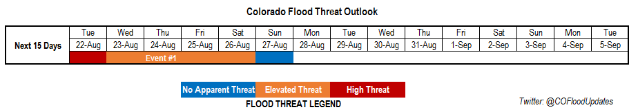
Valid Dates: 8/22-9/5
As seen on the water vapor image below, a strong upper-level ridge resides over the Pacific Northwest. At 500mb there is also a Low pressure system off the coast of southern California. With a broad area of higher pressure aloft over Texas, the gradient between the Low and High pressure has advected a plume of monsoon moisture into the state. With slow and variable steering winds aloft under the ridge, the increase in moisture has brought a High Flood Threat to Colorado tomorrow and an Elevated Flood Threat through Saturday.
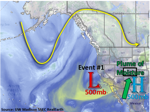
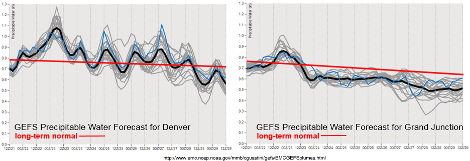
Below are the forecasted Precipitable Water (PW) plumes for Denver and Grand Junction. The PW began to increase Sunday afternoon, but is expected to peak Tuesday evening. PW will be higher than the long-term normal at both locations and could reach as high as 1.3 inches over SE Colorado. This setup is similar to the active period at the end of July, except no mid-level high pressure is well-defined over Texas during the full period. This may limit the intensity of the moisture advection and confine the higher moisture to southern Colorado and the eastern plains. The surge of moisture, and antecedent atmospheric moisture, hangs around through Sunday evening. The extended period of active weather has been labeled as Event #1.
On Thursday, the upper-level low pressure system begins to move eastward. With the elevated moisture in the atmosphere, this extra energy could support stronger storms and widespread rainfall over the eastern plains. There is enough confidence to identify this period as an elevated threat, although the full details of this event are still developing. Please check back to the daily Flood Threat Bulletin for more detail.
Below we describe Event #1 in more detail.
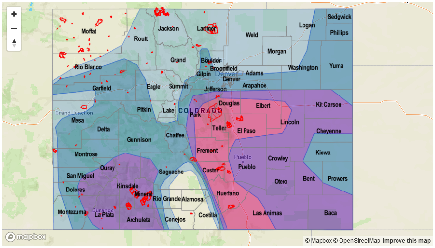
Event #1: Tuesday (8/22) through Sunday (8/27)
High/Elevated Flood Threat as monsoon moisture plume creates daily rounds of heavy rainfall.
A plume of monsoon moisture continues to make its way into Colorado peaking Tuesday evening. A mid-level Low/High pressure gradient has created a strong southerly component to the flow that is advecting moisture into Colorado. Short-term heavy rainfall will be likely over the climatologically favored regions of southwestern Colorado, Southeast Mountains and Palmer Ridge daily throughout this week. On Thursday, the mid-level Low pressure system will move through Colorado and is expected to produce another round of heavy precipitation that could last into the overnight hours. Max 1-hour rainfall rates greater than 1.5 inches (east) and 1.0 (west) are expected tomorrow afternoon and evening. With slow steering winds under the ridge and elevated moisture, it is likely max 1-hour rain rates could exceed those same thresholds throughout the week. Threats include flash flooding as well as debris slides and mud flows over the higher terrains and susceptible burn scars. Multiple rounds of rainfall will also increase these threats as the soil becomes saturated towards the end of the week.