Issue Date: Monday, August 14, 2017
Issue Time: 3PM MDT
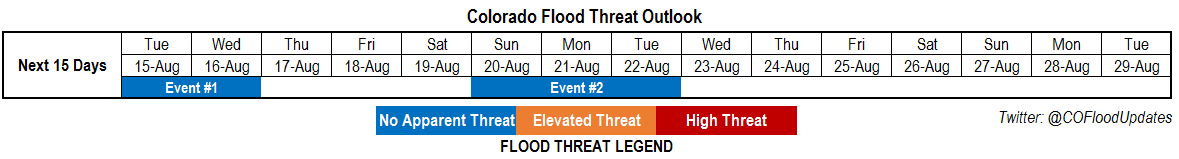
Valid Dates: 8/15-8/29
As shown in the water vapor image, below, a dynamic “high-amplitude” pattern is currently found across the eastern North Pacific and western parts of North America. A strong low-pressure trough is currently entering the US west coast, supported mainly by the jet stream though moisture return is not all that impressive. As this disturbances makes it to Colorado, we expect an increase in shower and thunderstorm coverage over the next 48 hours. However, with fast steering winds, and marginal low-level moisture, flooding is not currently expected with this event (Event #1).
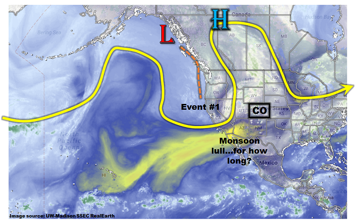
Thereafter, large-scale drying is expected as a more zonal flow brings in drier air from the west. As shown in the forecasted Precipitable Water (PW) plumes, below, this drying will be more marked west of the Continental Divide. For example, Grand Junction’s PW is forecasted to dip as low as 0.4 inches by Thursday 8/17, which is substantially below normal. East of the Continental Divide, moisture as measured by the entire atmospheric column will be close to seasonal averages, but persistent and modestly strong westerly steering winds will provide for general downsloping (drying) conditions, limiting heavy rainfall chances and actually precipitation, in general.

Looking farther out, given that we are still in the midst of the monsoon season, it is no surprise to see guidance suggesting the development of another large-scale moisture surge by early next week. At this time, this surge appears to be too brief in duration, with only marginal moisture. Thus, we label it as Event #2, but no flood threat is currently foreseen.
Each of the two identified events are described in more detail below.
Event #1: Tuesday (8/15) and Wednesday (8/16)
No Apparent Flood Threat but scattered to widespread showers and weak thunderstorms are expected
The disturbance currently entering the west coast will provide scattered to numerous shower and thunderstorm activity both Tuesday and Wednesday across most of the state. However, with fast storm steering winds, above 30mph, and marginal moisture (PW will stay below 1 inch except for far eastern areas), only light to moderate rainfall amounts are expected. Generally, most locations will see up to 0.5 inches over this 48-hour period. However, isolated parts of the eastern Plains may see up to 1.5 inches (especially under the strongest storms). Flooding is not expected at this time. However, severe weather, notably large hail and gusty straight-line winds, may accompany the strongest storms.

Event #2: Sunday (8/20) through Tuesday (8/22)
No Apparent Flood Threat at this time as monsoon surge likely to enter western Colorado
The main uncertainty with this event is the extent of moisture return. Current guidance suggests PW up to 0.8-0.9 inches could enter far southwest Colorado. If this comes to fruition, a low-grade flood threat could arise in the climatologically favored parts of the San Juans, Sawatch, Elk ranges, Grand Mesa and Roan Cliffs. However, there is currently too much uncertainty to warrant an Elevated flood threat. Thus, while enhanced precipitation chances and coverage is likely, totals are expected to remain below 1 inch. Stay tuned to this Thursday’s Outlook for an update.