FTO 05-21-2018: Dry and Hot to the West and Scattered Afternoon Showers to the East

Issue Date: Monday, May 21th, 2018
Issue Time: 2:40PM MDT
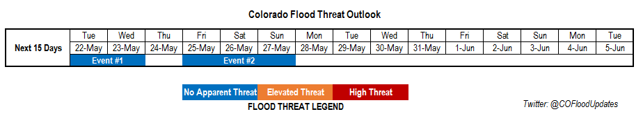
Valid Dates: 5/22 – 6/5

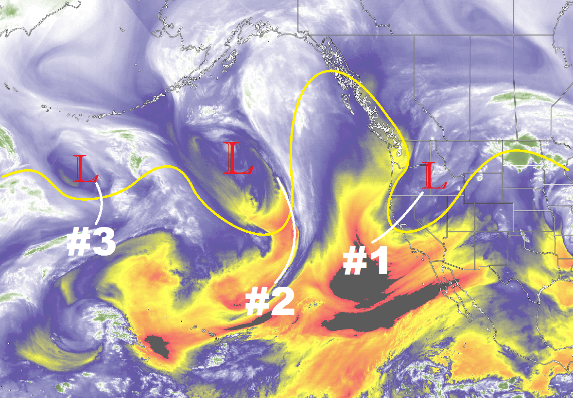
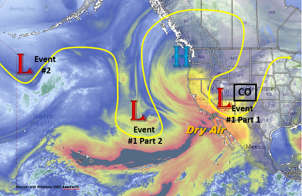
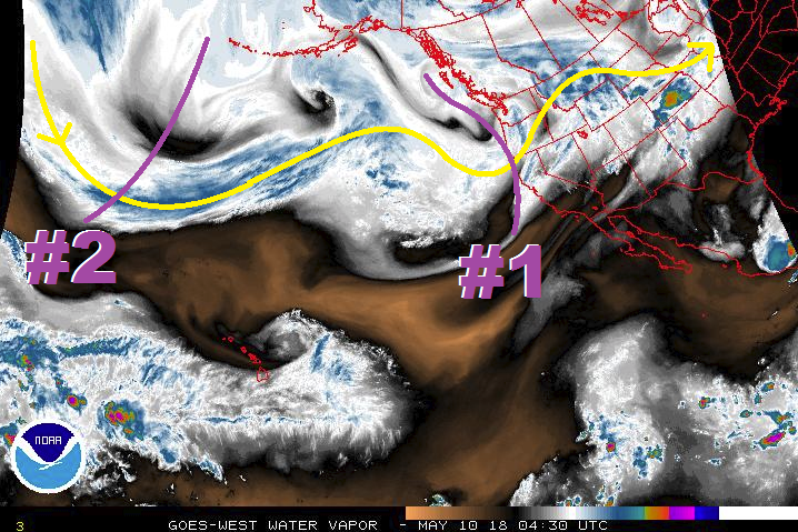
The North Pacific water vapor imagery below shows a split pattern of the polar jet stream, which will be the focus of this next FTO period. The notably strong low over the gulf of Alaska will continue to support troughing over the west coast with a on and off ridging pattern over Colorado. This continuous pattern over the past couple of weeks has brought either an active rainfall pattern or a high fire threat depending on the moisture associated with each passing trough.

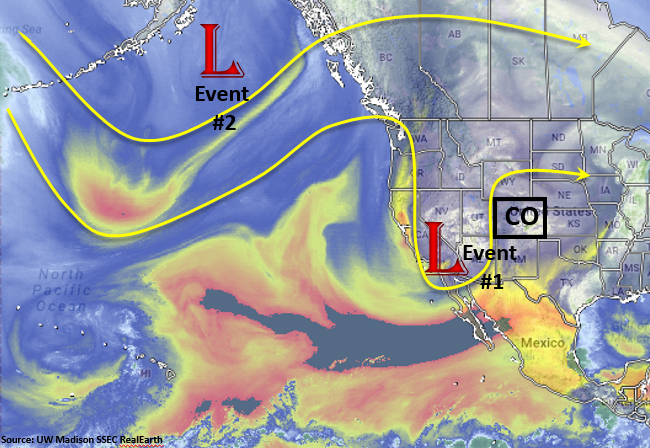
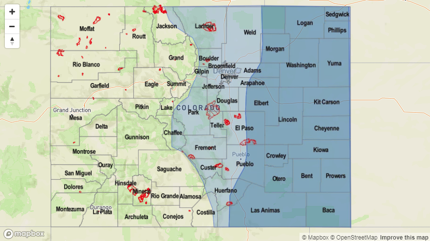
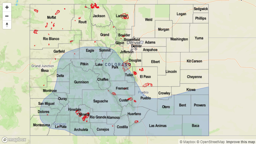
Currently, the upper trough positioned over southern California has provide moisture and upper-level support for scattered thunderstorms over the higher terrains Sunday into Monday both east and west of the Continental Divide. Southerly winds from the low will continue to pull higher Precipitable Water (PW) values further northwards to continue Event #1 on Tuesday.

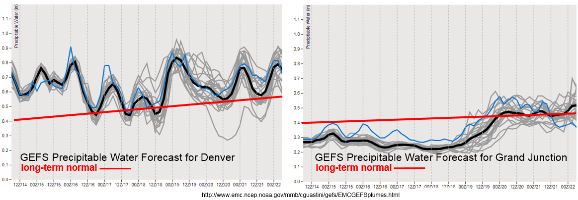
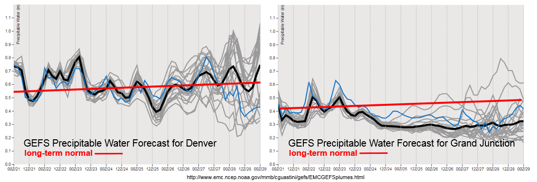
The GEFS PW plume forecast for Denver and Grand Junction shows this above average moisture crawling northward through Tuesday. However, after Tuesday, Denver returns to average PW and the chance for heavy rainfall is limited to the far eastern plains where better moisture remains. However, with quick storm motion, only isolated rainfall is expected. West of the Divide, PW drops very far below average through next Monday. The low moisture, associated with a building ridge, will continue to dry the ground throughout the week. Possible high winds this weekend over western Colorado may enhance fire weather conditions, so monitor weather conditions closely and use caution while burning outdoors.

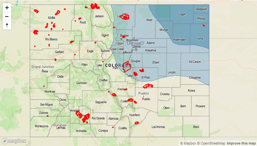
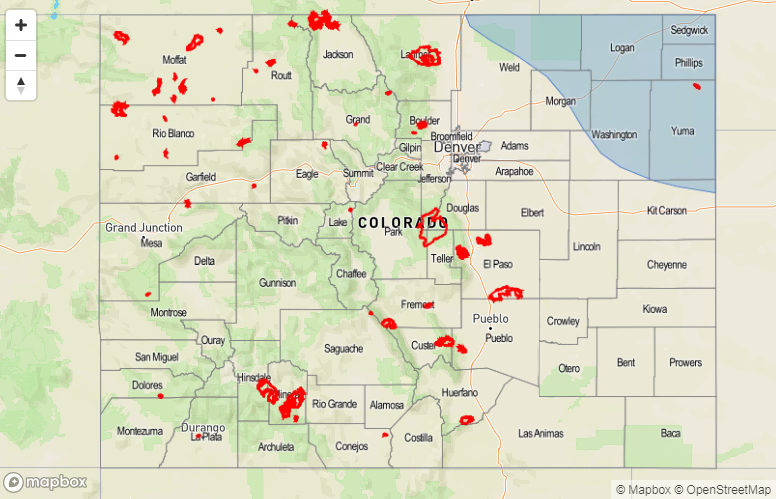
Event #2 occurs at the end of this week as the low pressure over Alaska produces another open trough over the West Coast. With PW currently forecasted to be about average, there is no heavy rainfall threat at this time. However, check back to Thursday’s FTO for changes to the forecast. Below we describe the identified precipitation event in more detail.

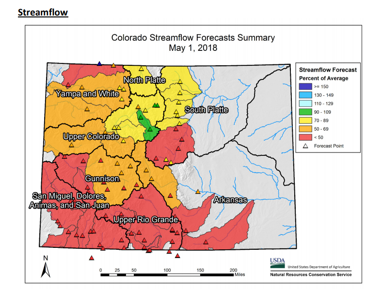
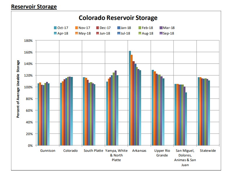
On another note, we are nearing peak streamflow time for Colorado’s rivers. Cooler temperatures and short periods of warm temperatures has prevent excess runoff so far this season. Peak flow this year are expected to be below average due to very low snowpack (with the exception of the Northern Mountains). The Colorado Streamflow Forecast Summary for May 1 below shows much below average streamflow for Colorado. Thankfully, reservoir storage is at or above 100% of average (source: NRCS). The Yampa, Elk, Gunnison and Colorado Rivers have likely reached their peak flows for the season. The Yampa peak streamflow was measured at 2,570 cfs putting it at its lowest peak since 2012. The Elk is sitting around 1,570 cfs. Combined, the Gunnison and Colorado rivers had the third earliest peak recorded with 8,500 cfs. This puts the Gunnison and Colorado rivers at the fourth lowest peak streamflow ever recorded.

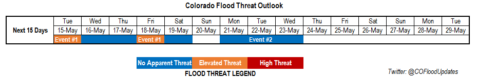
Event #1: Tuesday (5/22) – Wednesday (5/23)

No Apparent Threat as the upper disturbance over Nevada begins to breakup over the Great Basin

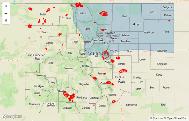
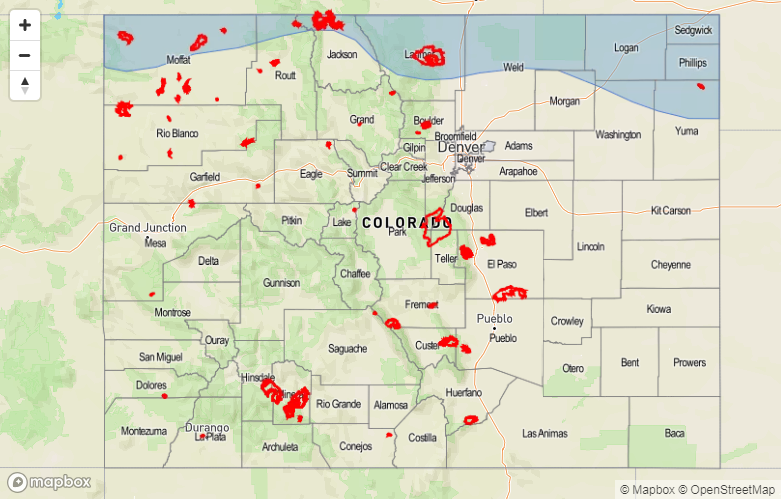
PW continues to increase to the north with southerly winds pulling in moisture from New Mexico. This should cause another round of scattered showers and thunderstorms for the higher terrains and western slope Tuesday. Energy released from the trough as it begins to fall apart will help provide upper support for more widespread development of thunderstorms when compared to Monday. A line of thunderstorms will likely develop over the Southeast Plains Tuesday afternoon as storms move off the higher terrain. The main threats will be gusty winds and quarter size hail. Wednesday, some more isolated storms could be possible over the eastern plains where moisture is able to remain intact. For details Wednesday, stay tuned to the daily FTB. At this time there is no apparent flood threat.

Legend

Event #2: Friday (5/25) – Sunday (5/27)

No Apparent Threat as another trough spins into place over southern California

Towards the start of next weekend, the next trough will set up west of Colorado. As mentioned above, the chances of heavy rainfall depend on the moisture content of each trough. Currently the GEFS has the ridge over eastern Colorado, which means very little moisture is expected for afternoon thunderstorms. So expecting the scattered storms to be confined to the higher terrains at this time with isolated pockets receiving up to 0.5 inches of rainfall for the weekend. There is also a chance for stronger storms and heavier rainfall over the eastern plains due to better moisture and dynamics each afternoon. However, details are a bit hard to pinpoint at this time. Please check back to Thursday’s FTO for changes to the forecast.

Legend

FTO 05-17-2018: Unsettled Weather Pattern Ahead

Issue Date: 5/17/2018
Issue Time: 12:10 PM

An unsettled pattern awaits Colorado for the better part of the next 10 days, as multiple waves (events) will take shots at the state. Outlined in the water vapor image below are three events, each of which will pose a slightly different threat to Colorado. Starting off with Event #1 (Friday, May 18th – Saturday, May 19th), it has been designated as an elevated flood threat, and with good reason. The upper-level trough denoted with the “#1” is in no hurry to move eastward, allowing for multiple days of broad upper-level support to overlay good low-level moisture influx from the east. This will result in an environment favorable to scattered-to-widespread thunderstorm coverage, where a handful will be on the strong-to-severe side. Precipitable water values will be near an inch across the Eastern Plains, which will be more than enough for the production of heavy rain, especially this early in the season. Between the daily afternoon/evening thunderstorms, overnight showers will keep things wet over the Front Range, Urban Corridor, Palmer Ridge, and eastern Plains. The system will exit off to the east by Sunday morning, and a “dirty ridge” will set up shop for two days in advance of Event #2. Even though temperatures will warm and sunshine will increase, daily thunderstorms can be expected as daytime heating and orographic effects work together on residual moisture.

Event #2 will begin to make its presence felt on Tuesday, May 22nd, as the upper-level wave brings upper-level support to the region for scattered showers/thunderstorms. As has been the case for the storms so far this season, the Northeast Plains stand to gain the most rainfall, mainly near the CO/NE border. This wave will become cutoff from the main flow regime over the Great Basin for a day or two, before finally moving east by the morning of Friday, May 25th. Currently, the best support appears to remain north of Colorado, keeping the heaviest rain out of the state. Therefore, it will be designated as “no apparent threat.” We will continue to monitor Event #2 in the coming days.

Event #3 (May 26th – May 27th) is an energetic shortwave, currently positioned near the Aleutian Islands. It will follow closely behind Event #2, with only one day between the end of #2 and start of #3. Right now, this wave appears to move quickly enough to not warrant a flood threat, but it should be noted that these types of waves can produce severe weather across the eastern plains. After Event #3, the weather will look to quiet down as ridging builds over the western US in response to a stubborn, upper-level trough over the eastern US.

Event #1: Friday (05-18-2018) and Saturday (05-19-2018)

Elevated Flood Threat as Slow-Moving System Works with Influx of Moisture

Event #1 is categorized by a slow-moving upper-level trough and an influx of low-level moisture from the east. Severe weather will be a threat across eastern Colorado during both days of the event, thanks to favorable moisture, instability, and wind profile. Multiple rounds of thunderstorms, coupled with rising streamflow conditions due to snowmelt are the main culprits behind the flood threat. Be sure to check in with the daily FTB for up-to-date flood threat information.

Legend

Event #2: Tuesday (05-22-2018) through Thursday (05-24-2018)

No Apparent Threat as Best Support Remains over Wyoming/Nebraska

Another slow-moving upper-level system will impact Colorado May 22nd – May 24th, bringing another couple of rounds of showers/thunderstorms to the state. The best upper-level support looks to remain to the North and East of Colorado, so at the current time, no flood threat is apparent. Should this system shift southward, heavy rain will become more likely. We will keep an eye on this system and provide an update in Monday’s FTO.

Legend

Event #3: Saturday (05-26-2018) and Sunday (05-27-2018)

No Apparent Threat as Quick Moving Shortwave Passes Overhead

A quick moving shortwave is culprit behind Event #3, resulting in a day or two of afternoon/evening showers and thunderstorms. Quick moving shortwaves like this often result in severe weather across the eastern plains, provided sufficient moisture in the low-levels. The evolution of this system will be closely monitored, and an update will come in Monday’s edition of the FTO.

FTO 05-14-2018: Active Weather Pattern Continues through Saturday

Issue Date: Monday, May 14th, 2018
Issue Time: 2:50PM MDT
Valid Dates: 5/15 – 5/29

The upper disturbance that has sat over the Great Basin the last few days will begin to break apart Tuesday night. This feature has kept cool temperatures and unsettled weather over the northeastern portion of Colorado and dry, warm temperatures over western and southern Colorado. The very dry air can be seen in this afternoon’s water vapor imagery below. Due to overlapping timescales, Event #1 has been broken into two parts for this edition of the 15-day Flood Threat Outlook.

Event #1 (Part 1) for this period begins with dissipation of the trough over Nevada. This will provide upper air support for thunderstorms east of the Continental Divide Tuesday where better moisture remains intact from southerly flow. As soon as the trough moves out of the area, a second trough (Part 2 of Event #1) begins to move into California Wednesday morning. Southwesterly and westerly flow will continue through the end of this week with ample moisture for multiple days of thunderstorms east of the Divide as seen in the moisture plumes below. A cold front pushes through the area Friday overnight/Saturday morning, which will be the greatest chance for heavy rainfall. A more settled weather pattern is expected for the second half of this weekend.

At the beginning of next week, Event #2 begins as a very week upper trough over the Pacific Ocean settles west of Colorado. This trough may provide a couple days of light showers that are greatly needed over the southwest portion of the state; however, moisture will be a limiting factor to heavy rainfall. The trough quickly moves to the east Tuesday, and by Wednesday, a large ridge will begin to build over the region.

The entirety of Event #1 will be marked by a longer period of above average Precipitable Water (PW) in Denver as seen in GEFS forecast above. The passage of the cold front Friday night paired with above average PW will give the greatest chance for heavy rainfall over northeastern Colorado this week. PW over Grand Junction also increases, but only towards the end of the week with the passage of the cold front. With an average PW of 0.4 inches, only limited rainfall is expected at this time in western Colorado. This means elevated fire danger will continue over the southwest portion of the state for the first part of this week. Below we describe the two identified precipitation events in more detail.

Event #1: Tuesday (5/15) – Saturday (5/19)

Elevated/No Apparent Threat as high PW pairs with upper disturbance for multiple rounds of thunderstorms in eastern Colorado

Moisture continues to stream in from the south and east over the eastern portion of Colorado for this period. Isolated, severe thunderstorms are expected to persist each afternoon initiating over the higher terrains and eastern plains convergence zone. Friday night into Saturday, a cold front moves through the state, which will bring the second chance for heavy rainfall this week. The best chances for heavy rainfall totals will be over the Front Range, Urban Corridor, Palmer Ridge and Northeast Plains. 1-hr rain rates under the stronger storms could be up to 1.25 inches/hour. West of the Continental Divide, the best chance for rain occurs with the passage of the cold front later this week. The highest totals will be confined to the Northern Mountains. Once again, this event is not expected to produce rainfall over southwestern Colorado.

Legend

Event #2: Monday (5/21) – Wednesday (5/23)

No Apparent Threat as a weak trough moves west from the Pacific Ocean

Towards the beginning of next week, another weak trough will set up to the west of Colorado. Currently, the heavier moisture will be restricted to the eastern plains, but some moisture returns to western Colorado. The upper dynamic support for thunderstorms is unknown at this time, but, currently, the heavy rainfall potential is low. Some much needed rainfall may occur over the southwest portion of the state, but totals are forecasted to be under 0.5 inches. At this time no precipitation map was created for this event. Please check back to Thursday’s FTO for changes to the forecast.

FTO 05-10-2018: Two Events, Neither Expected to Bring Flood Threat

Issue Date: 5/10/2018
Issue Time: 9:00 AM

Today’s edition of the FTO features two events, both highlighted in the water vapor imagery below. Event #1 is an extended event, covering five days, but will be marked more by windy conditions and warm temperatures than rainfall capable of flooding. Currently, Event #1 is marked by a mid-/upper-level low-pressure trough, with its circulation centered of the coast of the Pacific Northwest and southwest Canada. This low pressure circulation will drop southward into the Great Basin by late Friday (May 11th), placing Colorado under southwest flow aloft. This southwest flow will be dry, as indicated by the vast expanse of dry air (brown colors in water vapor image) currently situated across the eastern Pacific. The low-pressure aloft will basically spin in place through Tuesday (May 15th) as it becomes cutoff from the main flow and blocking sets up. A surface cold front will oscillate north and south across the state this weekend while the low pressure spins in place, attempting to allow low-level moisture to return. It isn’t expected to result in much precipitation potential, but will allow for a few isolated showers/thunderstorms to develop daily, mainly over the Northern Mountains, Central Mountains, Front Range, Urban Corridor, Palmer Ridge, and Northeast Plains regions. By Tuesday (May 15th), the low-pressure will finally be washed out and kicked to our east by a high-pressure ridge ahead of the approach of another low-pressure system (Event #2).

Between Event #1 and Event #2, a couple of dry days are expected as a transient high pressure ridge briefly takes over. Event #2 will begin next Friday, May 18th, as the next upper-level low moves into the Great Basin. This low will move much quicker across the region than Event #1, as blocking fails to set up and the low remains a part of the main flow regime. This system will have more moisture with it, as low level flow helps transport Gulf of Mexico moisture across the Great Plains and into Colorado, but unfortunately it appears the bets upper-level support will remain to our north and east, hampering our rainfall potential. Still, this event needs careful watching, because a shift south in the low track would bring heavier rain to the state. After Event #2, uncertainty reigns supreme, which is typical for this time of year. Models have been trending towards and third event to closely follow Event #2 on Monday, May 21st through Tuesday, May 22nd, but it is too uncertain at this time to make that call. We will keep a close eye on this and have more information in Monday’s edition of the FTO.

Event #1: Friday (05-11-2018) through Tuesday morning (05-15-2018)

No Apparent Threat as Dry Air Shunts Precipitation Potential

The low-pressure aloft that is the focus of Event #1 will become cutoff from the main flow regime, spinning in place over the Great Basin for the better part of 5 days. Unfortunately, it will remain too far west to bring good moisture into the state, instead pulling dry air from the eastern Pacific into our area. Fire danger will mark this period more than precipitation, as windy conditions are expected as the pressure gradient remains fairly strong due to the pattern. A few isolated showers/thunderstorms will be possible, though, mainly across the Northern Mountains, Central Mountains, Front Range, Urban Corridor, Palmer Ridge, and Northeast Plains regions as an oscillating frontal boundary tries to bring Great Plains moisture into the area.

Legend

Event #2: Friday (05-18-2018) through Saturday (05-19-2018)

No Apparent Threat as Best Support Remains over Wyoming

A much quicker moving event than Event #1, Event #2 features an upper-level low that will traverse Colorado over two days. Unfortunately for our rain chances, this low will keep the best support aloft over Wyoming. However, easterly low-level flow will attempt to bring Great Plains/Gulf of Mexico moisture into eastern Colorado, which will set the stage for a classic eastern Colorado severe weather event. Flash flooding isn’t anticipated at this moment, but isolated-to-scattered thunderstorms would bring brief shots of heavy rain to the eastern Plains. We’ll keep an eye on this event as we get closer.

Legend