Issue Date: 5/17/2018
Issue Time: 12:10 PM

An unsettled pattern awaits Colorado for the better part of the next 10 days, as multiple waves (events) will take shots at the state. Outlined in the water vapor image below are three events, each of which will pose a slightly different threat to Colorado. Starting off with Event #1 (Friday, May 18th – Saturday, May 19th), it has been designated as an elevated flood threat, and with good reason. The upper-level trough denoted with the “#1” is in no hurry to move eastward, allowing for multiple days of broad upper-level support to overlay good low-level moisture influx from the east. This will result in an environment favorable to scattered-to-widespread thunderstorm coverage, where a handful will be on the strong-to-severe side. Precipitable water values will be near an inch across the Eastern Plains, which will be more than enough for the production of heavy rain, especially this early in the season. Between the daily afternoon/evening thunderstorms, overnight showers will keep things wet over the Front Range, Urban Corridor, Palmer Ridge, and eastern Plains. The system will exit off to the east by Sunday morning, and a “dirty ridge” will set up shop for two days in advance of Event #2. Even though temperatures will warm and sunshine will increase, daily thunderstorms can be expected as daytime heating and orographic effects work together on residual moisture.
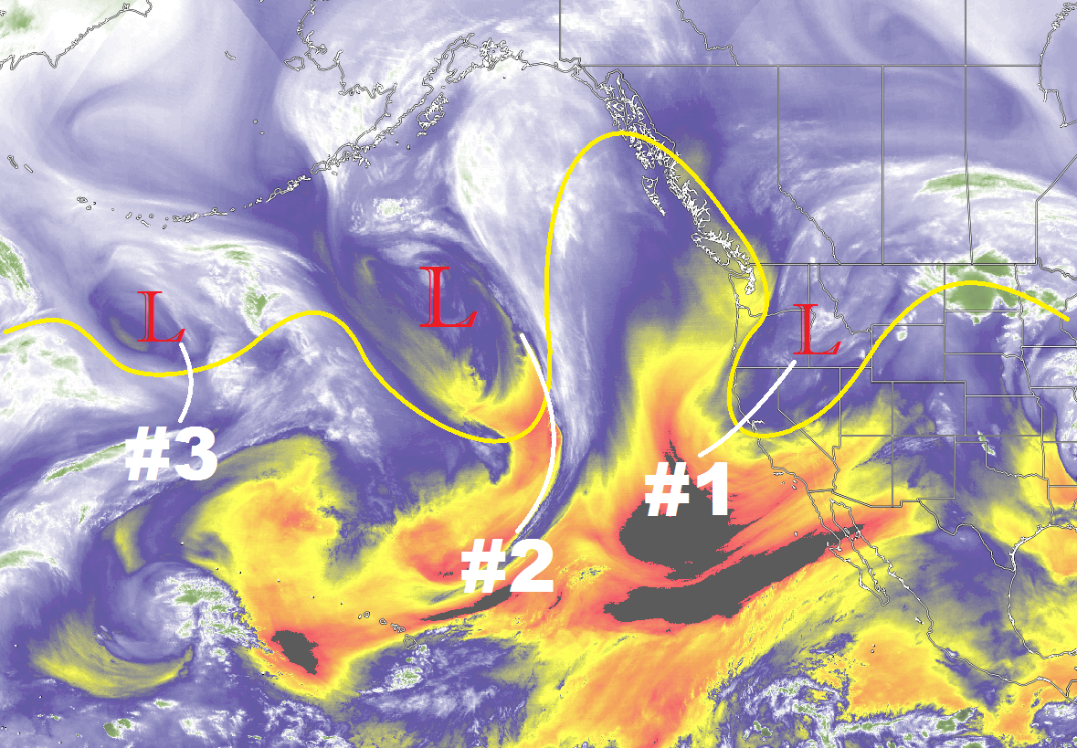
Event #2 will begin to make its presence felt on Tuesday, May 22nd, as the upper-level wave brings upper-level support to the region for scattered showers/thunderstorms. As has been the case for the storms so far this season, the Northeast Plains stand to gain the most rainfall, mainly near the CO/NE border. This wave will become cutoff from the main flow regime over the Great Basin for a day or two, before finally moving east by the morning of Friday, May 25th. Currently, the best support appears to remain north of Colorado, keeping the heaviest rain out of the state. Therefore, it will be designated as “no apparent threat.” We will continue to monitor Event #2 in the coming days.
Event #3 (May 26th – May 27th) is an energetic shortwave, currently positioned near the Aleutian Islands. It will follow closely behind Event #2, with only one day between the end of #2 and start of #3. Right now, this wave appears to move quickly enough to not warrant a flood threat, but it should be noted that these types of waves can produce severe weather across the eastern plains. After Event #3, the weather will look to quiet down as ridging builds over the western US in response to a stubborn, upper-level trough over the eastern US.
Event #1: Friday (05-18-2018) and Saturday (05-19-2018)
Elevated Flood Threat as Slow-Moving System Works with Influx of Moisture
Event #1 is categorized by a slow-moving upper-level trough and an influx of low-level moisture from the east. Severe weather will be a threat across eastern Colorado during both days of the event, thanks to favorable moisture, instability, and wind profile. Multiple rounds of thunderstorms, coupled with rising streamflow conditions due to snowmelt are the main culprits behind the flood threat. Be sure to check in with the daily FTB for up-to-date flood threat information.

Event #2: Tuesday (05-22-2018) through Thursday (05-24-2018)
No Apparent Threat as Best Support Remains over Wyoming/Nebraska
Another slow-moving upper-level system will impact Colorado May 22nd – May 24th, bringing another couple of rounds of showers/thunderstorms to the state. The best upper-level support looks to remain to the North and East of Colorado, so at the current time, no flood threat is apparent. Should this system shift southward, heavy rain will become more likely. We will keep an eye on this system and provide an update in Monday’s FTO.
Event #3: Saturday (05-26-2018) and Sunday (05-27-2018)
No Apparent Threat as Quick Moving Shortwave Passes Overhead
A quick moving shortwave is culprit behind Event #3, resulting in a day or two of afternoon/evening showers and thunderstorms. Quick moving shortwaves like this often result in severe weather across the eastern plains, provided sufficient moisture in the low-levels. The evolution of this system will be closely monitored, and an update will come in Monday’s edition of the FTO.