Issue Date: Monday, May 14th, 2018
Issue Time: 2:50PM MDT
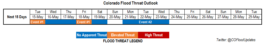
Valid Dates: 5/15 – 5/29
The upper disturbance that has sat over the Great Basin the last few days will begin to break apart Tuesday night. This feature has kept cool temperatures and unsettled weather over the northeastern portion of Colorado and dry, warm temperatures over western and southern Colorado. The very dry air can be seen in this afternoon’s water vapor imagery below. Due to overlapping timescales, Event #1 has been broken into two parts for this edition of the 15-day Flood Threat Outlook.
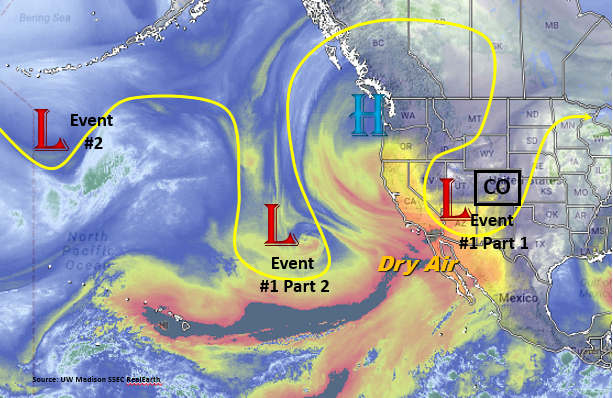
Event #1 (Part 1) for this period begins with dissipation of the trough over Nevada. This will provide upper air support for thunderstorms east of the Continental Divide Tuesday where better moisture remains intact from southerly flow. As soon as the trough moves out of the area, a second trough (Part 2 of Event #1) begins to move into California Wednesday morning. Southwesterly and westerly flow will continue through the end of this week with ample moisture for multiple days of thunderstorms east of the Divide as seen in the moisture plumes below. A cold front pushes through the area Friday overnight/Saturday morning, which will be the greatest chance for heavy rainfall. A more settled weather pattern is expected for the second half of this weekend.
At the beginning of next week, Event #2 begins as a very week upper trough over the Pacific Ocean settles west of Colorado. This trough may provide a couple days of light showers that are greatly needed over the southwest portion of the state; however, moisture will be a limiting factor to heavy rainfall. The trough quickly moves to the east Tuesday, and by Wednesday, a large ridge will begin to build over the region.
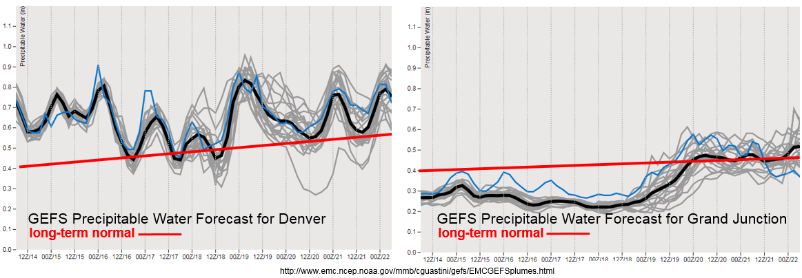
The entirety of Event #1 will be marked by a longer period of above average Precipitable Water (PW) in Denver as seen in GEFS forecast above. The passage of the cold front Friday night paired with above average PW will give the greatest chance for heavy rainfall over northeastern Colorado this week. PW over Grand Junction also increases, but only towards the end of the week with the passage of the cold front. With an average PW of 0.4 inches, only limited rainfall is expected at this time in western Colorado. This means elevated fire danger will continue over the southwest portion of the state for the first part of this week. Below we describe the two identified precipitation events in more detail.
Event #1: Tuesday (5/15) – Saturday (5/19)
Elevated/No Apparent Threat as high PW pairs with upper disturbance for multiple rounds of thunderstorms in eastern Colorado
Moisture continues to stream in from the south and east over the eastern portion of Colorado for this period. Isolated, severe thunderstorms are expected to persist each afternoon initiating over the higher terrains and eastern plains convergence zone. Friday night into Saturday, a cold front moves through the state, which will bring the second chance for heavy rainfall this week. The best chances for heavy rainfall totals will be over the Front Range, Urban Corridor, Palmer Ridge and Northeast Plains. 1-hr rain rates under the stronger storms could be up to 1.25 inches/hour. West of the Continental Divide, the best chance for rain occurs with the passage of the cold front later this week. The highest totals will be confined to the Northern Mountains. Once again, this event is not expected to produce rainfall over southwestern Colorado.

Event #2: Monday (5/21) – Wednesday (5/23)
No Apparent Threat as a weak trough moves west from the Pacific Ocean
Towards the beginning of next week, another weak trough will set up to the west of Colorado. Currently, the heavier moisture will be restricted to the eastern plains, but some moisture returns to western Colorado. The upper dynamic support for thunderstorms is unknown at this time, but, currently, the heavy rainfall potential is low. Some much needed rainfall may occur over the southwest portion of the state, but totals are forecasted to be under 0.5 inches. At this time no precipitation map was created for this event. Please check back to Thursday’s FTO for changes to the forecast.