FTO 06-18-2018: Heavy Rainfall Likely for Northeastern Colorado through Wednesday

Issue Date: Monday, June 18th, 2018
Issue Time: 2:40PM MDT
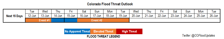
Valid Dates: 6/18 – 7/3

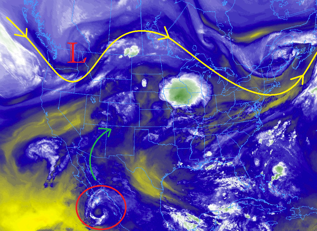
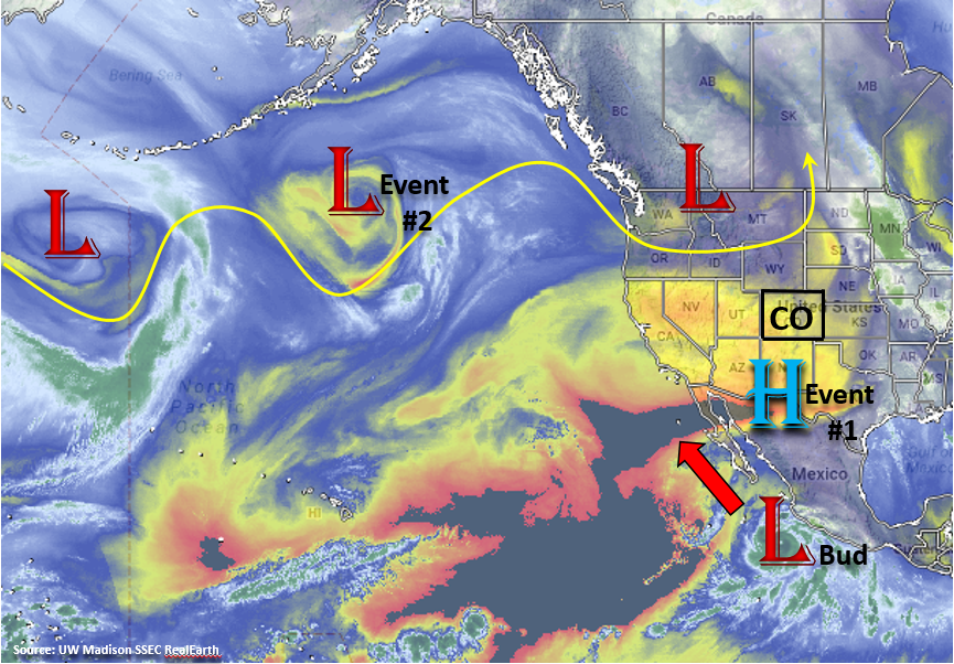
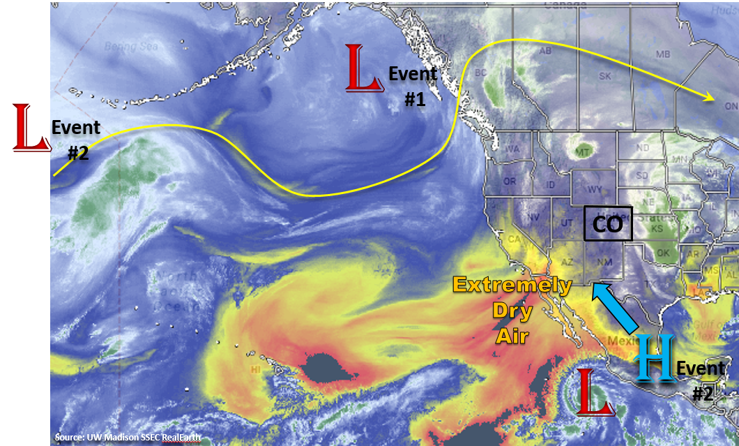
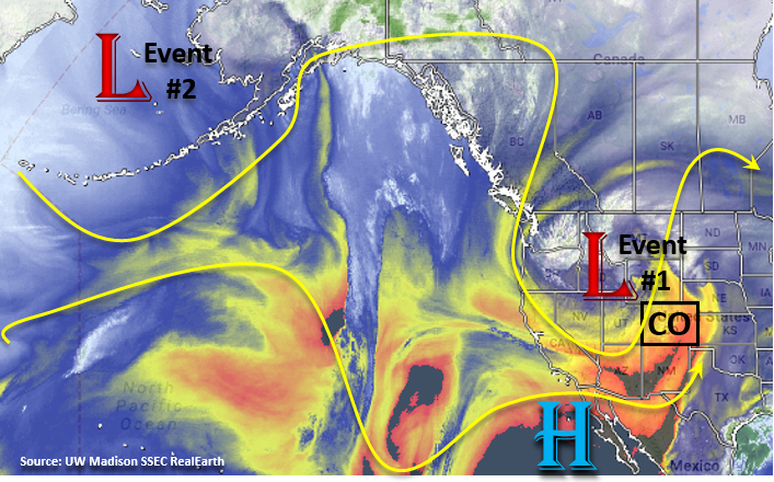
This next FTO period will begin with an Elevated flood threat as Event #2 continues from Thursday’s FTO (now Event #1). This upper trough will linger west and north of Colorado through Wednesday evening until is slowly slides east and breaks apart by Thursday morning. At this time a ridge begins to build to the west of Colorado. The ridge will pull in dry air over the majority of the state as seen in the water vapor imagery below. This will bring warm and dry weather to most of the state, but there still is a chance for some thunderstorms Thursday over the far eastern plains. At the start of next weekend, another trough drops into the Great Basin, which will give eastern Colorado and the northern high country another chance of more widespread thunderstorms and rainfall on Saturday and Sunday. The latest run of the GFS shows the upper low spinning over Colorado through Monday pulling in high dew points over the eastern plains. Starting Tuesday, the ridge beings to build back over Colorado drying out the atmosphere and limiting afternoon showers and thunderstorm development.

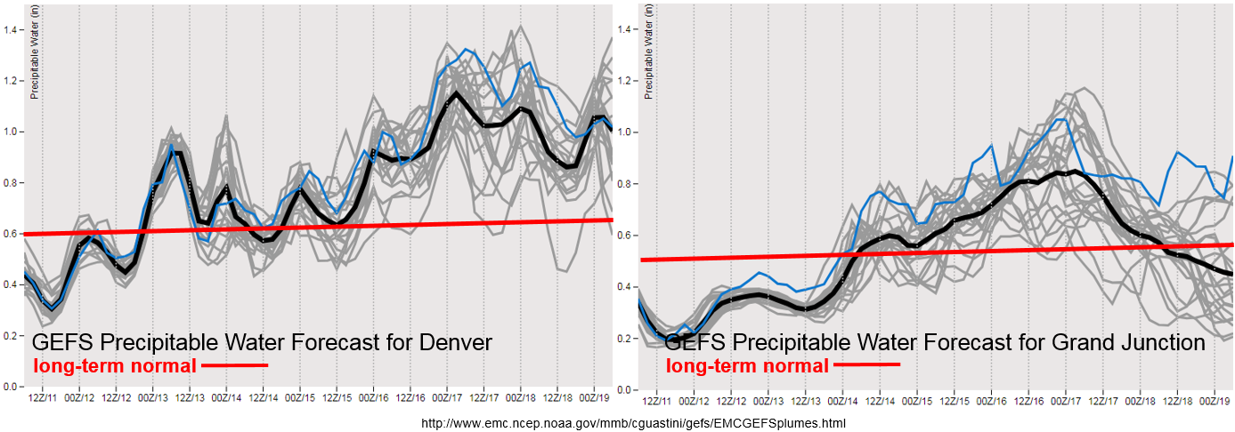
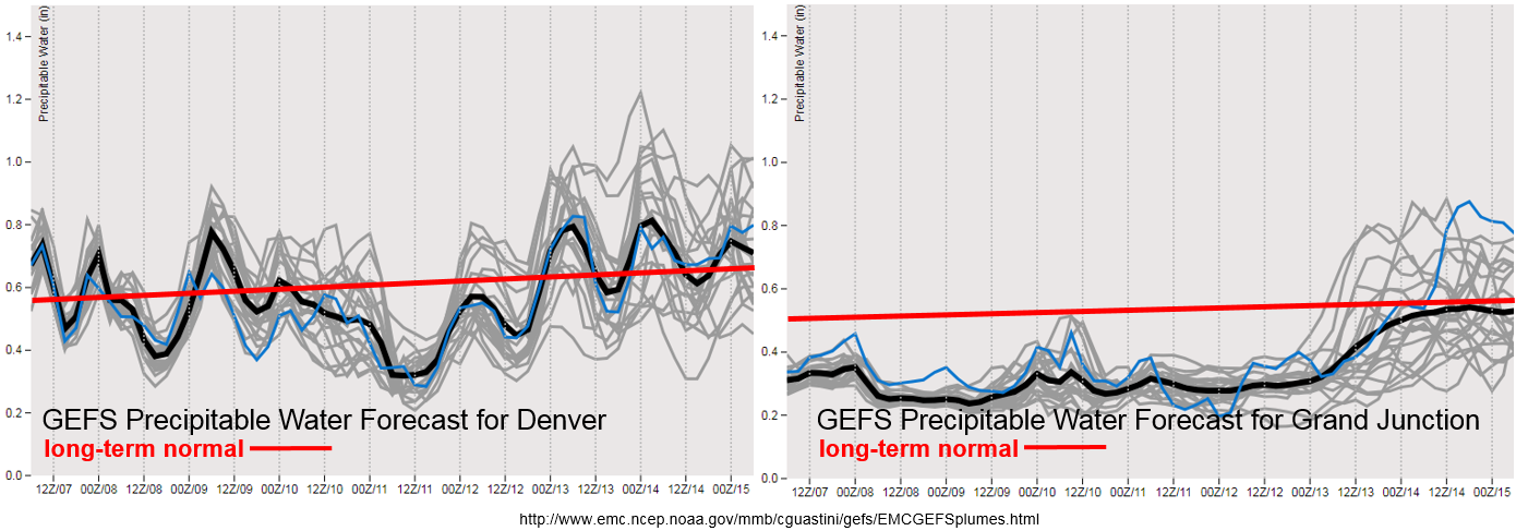
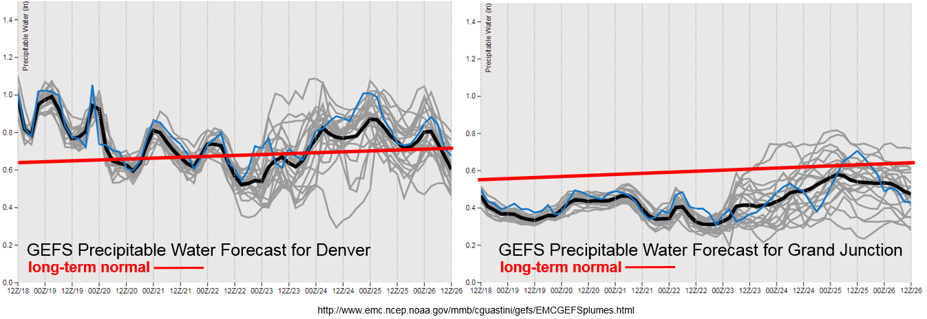
Precipitable Water (PW) values are not that impressive this next week for western Colorado. Although the forecast is hinting at some moisture return over the weekend, the chances of PW remaining below average are high. This should limit heavy rainfall chances and may cause some fire danger over the Central and San Juan Mountains as the trough drops into Colorado next weekend bringing stronger winds. East of the Continental Divide, tomorrow afternoon looks rather active over the Palmer Ridge/eastern plains with some severe thunderstorm action. Heavy rainfall chances also remain high with PW values close to or above 1 inch helping create high rainfall rates. Upper level dynamics will support widespread thunderstorm development tomorrow afternoon, and it is expected to continue through the early morning hours.

Below we describe each of the two identified precipitation events in more detail.

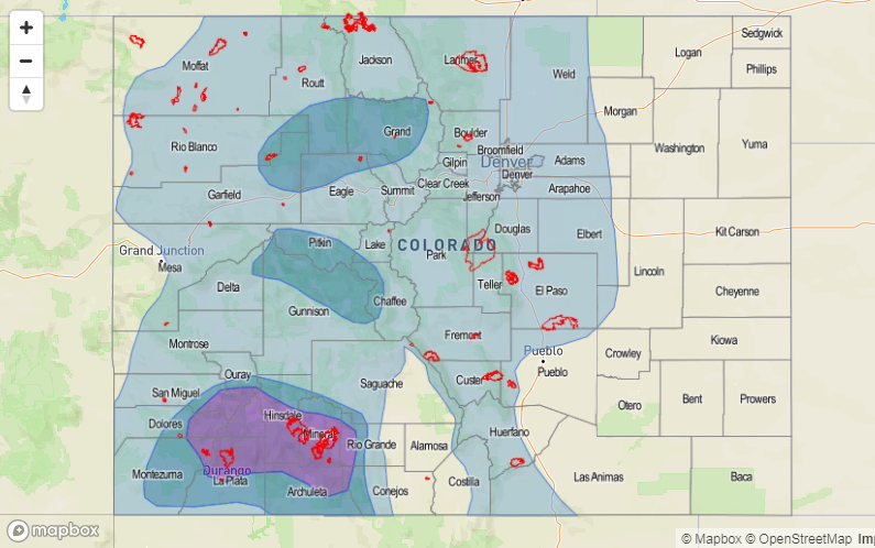
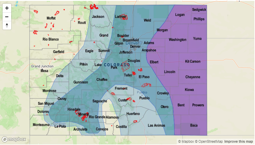
Event #1: Tuesday (6/19) – Thursday (6/21)

Elevated Flood Threat/No Apparent Threat as moisture remains high over the eastern plains and combines with favorable upper level dynamics to bring severe weather and heavy rainfall on Tuesday.

PW values over 1 inch are a good indicator of heavy rainfall potential. Tomorrow afternoon, the GEFS moisture plumes are indicating values greater than 1 inch over most of the eastern plains. With upper dynamic support, widespread thunderstorms (some severe) are forecast. Dew point values near the KS/CO border are forecast to reach 60-65F, which will cause flash flooding for storms that track over this area. Max 1-hour rain rates up to 1.8 inches/hour will be possible. Threats tomorrow include large hail, wind gust up to 60 mph and local heavy rainfall. Tune back into the FTB tomorrow morning for more details. Wednesday into Thursday, thunderstorm coverage is expected to decrease with the entrainment of more dry SW flow. Heavy rainfall chances will be confined to the eastern Colorado border.


Legend

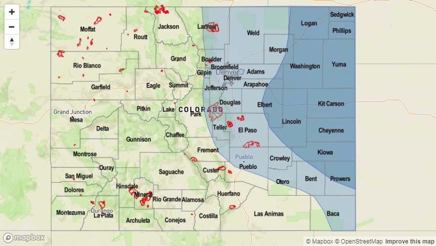
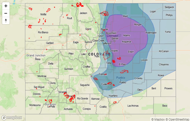
Event #2: Saturday (6/23) – Tuesday (6/26)

No Apparent Threat as the next trough drops into the Great Basin and spins over Colorado.

Confidence in the strength, timing and moisture associated with the next upper level trough is still fairly low. However, both global models indicate another trough sliding through the region at the end of this week. At this time, expect a general increase in thunderstorm coverage on Saturday and Sunday over northern and eastern Colorado. It is a bit early to tell how much moisture will accompany this system, but PW values hint at increases both east and west of the Divide. If PW is not able to substantially increase west of the Divide, expect Red Flag Warning and critical fire danger again this weekend as this trough passes through. The best chance for moisture west of the Divide will be over the Northern Mountains.


Legend

FTO 06-14-2018: High Flood Threat This Weekend, Elevated Flood Threat Next Week

Issue Date: 6/14/2018
Issue Time: 11:25 AM

NOTE: This edition of the FTO will be a bit different than previous editions, as this one will focus heavily on the flooding threat posed by Events #1 and #2 over the next 8 days.

The water vapor imagery below can tell us a lot about the upcoming weather situation, and I have highlighted the main features. The first thing that jumps off the page is circled in red. Formerly Hurricane Bud (now Tropical Storm Bud) is moving nearly due-northward, with its outflow moisture already being pulled into Colorado (as indicated by the green arrow). The upper-level low currently centered over the Pacific NW will continue to dig southward towards the Great Basin, enhancing the fetch of moisture from the Pacific into the 4-corners region. These features all set the stage for the High Flood Threat (Event #1) of Friday, June 15th to Sunday, June 17th.

Event #1: Friday (06-15-2018) through Sunday (06-17-2018): High Flood Threat

The remnants of Hurricane Bud are the main concern behind the High Flood Threat, as the moisture associated with it will push pockets of precipitable water values over an inch across much of Colorado beginning late Friday, and then becoming more widespread by Saturday afternoon through Sunday. One inch of precipitable water sets off alarm bells due to the precipitation efficiency it promotes from showers and thunderstorms. It will not take much instability to produce moderate-to-heavy rainfall under conditions such as these.

The Burro Fire and 416 Fire burn areas are of the most concern during this event for a few reasons: 1) They are recent/ongoing – soil has had no time to recover at all, making them highly susceptible to flash flooding, mud flows, and debris slides, 2) They are favorably positioned on the south/southwest facing slopes of the San Juan Mountains, which are expected to be the most heavily impacted by rainfall during this event, and 3) Rain rates as low as 0.25-0.5 inches/hour will be sufficient to produce the aforementioned threats in, and downstream of, these burn scars. Other High Country burn scars should be monitored, as well (including those in the Southeast Mountains).

Storm Motions, Rain Rates, and Prime Time:

  • The main threat period will be from 6 AM Saturday until Noon on Sunday, with the primetime being Noon to Midnight on Saturday. This is when the best moisture, instability, and upper-level support will coincide.
  • Storms will generally move in a north-northeastward direction at 15-25 mph
  • It is a bit premature to be talking rain rates, due to the primetime of the event still being 48 hours or so away. At this time, 1-hour rain rates greater than 0.25 inches/hour are likely over the burn scars. Be sure to pay close attention to the daily FTB for up-to-date and more specific information.
  • This event will be more of a 24-hour event than a 1-hour event. Most 24 hour totals will be in the 0.25-0.5 inch range, but localized 24-hour totals through Sunday morning of 1.0-1.25 inches will be possible. Totals for the entire event over the San Juan Mountains will be 1-2 inches, with localized areas receiving 2-2.25 inches. These higher totals are currently forecast to fall east of the burn scars as long as Bud maintains his current track. Again, please stay up-to-date with the daily FTB for changes to this forecast.

Drier air will begin to move into western Colorado on Sunday afternoon, but enough moisture will likely hang on for scattered showers/thunderstorms over the area.

Saturday and Sunday will be the main days for shower/thunderstorm activity for eastern Colorado associated with Event #1, as subtropical moisture increases the chances for wetting rainfall and low-level moisture recovers. A frontal passage on Sunday will bring upslope flow to the Front Range and Urban Corridor, so those areas will need to be monitored through the weekend. Eastern Colorado’s main event will be Event #2.

Legend

Event #2: Monday (06-18-2018) through Friday (06-22-2018): Elevated Flood Threat

Event #2 will immediately follow Event #1, as the upper-level low that set the stage for Event #1 becomes cut-off from the main flow regime, and “stalls” and gradually weakens over the Great Basin for the better part of the work week. This will result in a few days of continuous subtropical moisture pull into eastern Colorado, as well as low-level moisture from the east thanks to the development of a lee-side trough/surface low. Upslope flow, instability, and plenty of moisture will be present to produce daily rounds of thunderstorms capable of heavy rainfall from the Front Range/Southeast Mountains eastward, with the bulk of the activity occurring north of Highway 50. West of the Continental Divide, the low-levels will be too dry to result in much wetting rainfall, but with the recent heavy rain from Event #1, they will still need to be watched for any short-term flood threats that may develop.

Legend

FTO 06-11-2018: Reprieve from the Dry Conditions Just Around the Corner

Issue Date: Monday, June 11th, 2018
Issue Time: 12:45PM MDT
Valid Dates: 6/12 – 6/26

The water vapor imagery below shows a very dry and stable air mass over Colorado, which should limit widespread, heavy precipitation chances until this weekend. Currently, the trough over the northern MT and ID is beginning its move north and east of Colorado. This will start to decrease the wind speeds across the state, which reduces the critical fire weather. At this same time, the High pressure center over New Mexico and Arizona will build another ridge over the state, which should strengthen the next couple of days. By Tuesday, the orientation of the ridge axis will allow moisture to return to the far eastern plains with southerly and southeasterly low-level flow, which is the beginning of Event #1. CAPE and decent shear will combine over the Southeast Plains and Palmer Ridge for some severe weather action over the next couple of days. Slow steering winds and the return of moisture mark an Elevated flood threat for Tuesday and Wednesday over the eastern plains. The GEFS precipitable water (PW) plumes indicate PW values as high as 1 inch just east of Denver for Tuesday afternoon, which is a good indication of heavy rainfall and the potential for flooding for the severe thunderstorms.

The ridge will begin to be displaced east later this week as the trough over the Gulf of Alaska begins to move into the Great Basin (Event #2). This will begin strong southwest flow that will increase PW values west of the Continental Divide as seen in the GEFS plumes below. There is still quite a bit of spread as to how high these PW values will get (and how far north), but multiple runs of the GFS are predicting a steady increase in moisture by this weekend leading to more widespread, heavy rainfall coverage. Part of the reason for this increased moisture is that during this same time, Tropical Cyclone Bud will move north along the Baja of California. The TC will help pull in excess subtropical moisture where normally dry air is present. Also present Thursday through Sunday is a lee trough that will help pull in moisture over the eastern plains from the Gulf of New Mexico. Thus, the abundance of subtropical moisture over the state paired with slow moving storms will warrant an Elevated flood threat from Sunday into early next week. This may finally provide some relief to southern Colorado’s drought and hopefully help contain the fires that continue to burn out of control.

Below we describe each of the two identified precipitation events in more detail.

Event #1: Tuesday (6/11) – Thursday (6/14)

Elevated Flood Threat/No Apparent Threat as moisture returns to the eastern plains under the ridge and increases the chance for slow moving thunderstorms/severe weather.

Moisture returns to the eastern plains each afternoon, which increases the chances for some heavy rainfall under the ridging pattern due to slow steering winds. Tomorrow severe weather may be possible with CAPE values up to 3000 J/Kg and shear in the 30-40 knot range over the Southeast Plains. Threats include large hail, possible tornadoes and wind gust up to 60mph. Dew point values in the mid to upper 50Fs are enough to drop local, heavy rainfall with max 1-hour rain rates up to 1.8 inches/hour. Tune back into the FTB for more details each day during this event.

Legend

Event #2: Friday (6/15) – Tuesday (6/19)

Elevated Flood Threat as subtropical moisture is pulled northward into the state increasing PW values and the chances for widespread rainfall statewide.

Subtropical moisture will be pulled into western Colorado this weekend as the High shifts east over Texas and the trough drops into the Great Basin in what semi-resembles the monsoon. While there is a bit of uncertainty as to how much moisture will get pulled north, PW values increase well above average for this time of year thanks to TC Bud. Afternoon instability will create some much needed rainfall over the drought stricken region and 416 fire. Over eastern Colorado, strong southerly flow will pull in high moisture values as well from the Gulf of Mexico. Later this weekend a cold front will move through increasing upslope flow in its wake. This will help make rainfall more widespread in eastern Colorado and the mountains. The small details of this event will continue to evolve, which help with placement of the heavy rainfall, so please check back to Thursday’s FTO.

Legend

FTO 06-07-2018: Early Summer Heat Continues Statewide with an Increased Flood Threat Starting Next Week

Issue Date: Thursday, June 7th, 2018
Issue Time: 2:00PM MDT
Valid Dates: 6/8 – 6/22

Once again Colorado will be under a ridging pattern for the majority of this FTO period, which will keep temperatures well above average for this time of year. A hot and dry air mass has established itself over the Great Basin and continues to extend these conditions into western Colorado. This has also limited heavy rainfall over the majority of the state as the dry air has purged the upper and low levels of the atmosphere of moisture. The exception to this is over the Northeast Plains where daily easterly flow has allowed low-level moisture to return. As diurnal flow storms form over the higher terrains and move eastward into the higher dew points, they are able to become more efficient with their rainfall rates. Beginning Saturday, the low pressure ridge over the Gulf of Alaska will slide north of Colorado and briefly displace the strong ridge and bring cooler temperatures to the state on Monday (Event #1).

The Precipitable Water (PW) plumes below show the best moisture for Event #1 will be east of the Continental Divide once again. PW values increase each afternoon with easterly flow pulling in low-level moisture from the plains. By Monday, the PW values decrease below normal, which should give us a break from heavy rainfall until next Wednesday. At this time, PW begins to rise both east and west of the Divide as the Low and High pressure combine to pull in sub-tropical moisture into the state (Event #2). Disturbances within the ridge will help bring extra lift for thunderstorm development through the end of next week into the weekend. At this time there is a bit of uncertainty as to how far north the sub-tropical moisture will be pulled, but this could potentially create multiple days of heavy rainfall events. Even if high moisture doesn’t fully reach the state, there should be enough moisture for rounds of afternoon thunderstorms. Be sure to check back next Monday to see how the details of this event are evolving.

Below we describe each of the two identified precipitation events in more detail.

Event #1: Friday (6/8) – Sunday (6/10)

Elevated Flood Threat/No Apparent Threat as daily rounds of afternoon thunderstorms form over the high terrains.

Friday a similar pattern to the last 3 days with the possibility of severe storms and heavy rainfall over the far eastern plains. Low-level easterly flow will pull high dew points to the CO/KS border, which if the cap breaks, will create an Elevated flood threat. The details will become more apparent tomorrow morning, so check back to the FTB. This weekend, the low pressure over the Gulf of Alaska will slide inland just north of the state and providing increased lift for more numerous showers and thunderstorms over the northern mountains in the afternoon on Saturday. Moisture is expected to remain low enough that heavy rainfall is not expected. South, fire weather increases Saturday night into Sunday as the upper level trough increases wind speeds. Please use extra caution with open flames. By Monday, cooler temperatures and a more settled weather pattern are forecast to start the work week after the passage of a cold front Sunday night.

Legend

Event #2: Tuesday (6/12) – Friday (6/15)

Elevated Flood Threat/No Apparent Threat as a tropical moisture is potentially siphoned northward into the state.

Currently, the GFS is pulling the High pressure over Mexico north into Texas and New Mexico on Tuesday. Paired with another Low dropping south from the Gulf of Alaska, the two could unite to pull in abundant sub-tropical moisture into the state. If the moisture travels far enough north, this would allow afternoon thunderstorms to produce very high rainfall rates and create an Elevated flood threat. This forecast is likely to change quite a bit over the weekend, so check back to the FTO on Monday to find out more as the event evolves.

Legend