Issue Date: Monday, June 11th, 2018
Issue Time: 12:45PM MDT
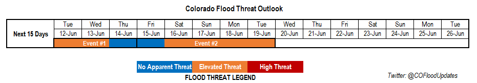
Valid Dates: 6/12 – 6/26
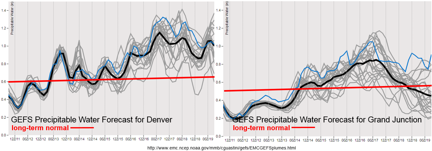
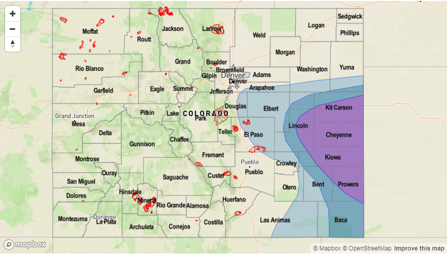
The water vapor imagery below shows a very dry and stable air mass over Colorado, which should limit widespread, heavy precipitation chances until this weekend. Currently, the trough over the northern MT and ID is beginning its move north and east of Colorado. This will start to decrease the wind speeds across the state, which reduces the critical fire weather. At this same time, the High pressure center over New Mexico and Arizona will build another ridge over the state, which should strengthen the next couple of days. By Tuesday, the orientation of the ridge axis will allow moisture to return to the far eastern plains with southerly and southeasterly low-level flow, which is the beginning of Event #1. CAPE and decent shear will combine over the Southeast Plains and Palmer Ridge for some severe weather action over the next couple of days. Slow steering winds and the return of moisture mark an Elevated flood threat for Tuesday and Wednesday over the eastern plains. The GEFS precipitable water (PW) plumes indicate PW values as high as 1 inch just east of Denver for Tuesday afternoon, which is a good indication of heavy rainfall and the potential for flooding for the severe thunderstorms.
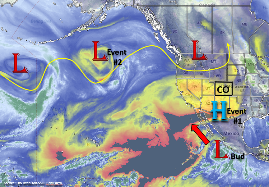
The ridge will begin to be displaced east later this week as the trough over the Gulf of Alaska begins to move into the Great Basin (Event #2). This will begin strong southwest flow that will increase PW values west of the Continental Divide as seen in the GEFS plumes below. There is still quite a bit of spread as to how high these PW values will get (and how far north), but multiple runs of the GFS are predicting a steady increase in moisture by this weekend leading to more widespread, heavy rainfall coverage. Part of the reason for this increased moisture is that during this same time, Tropical Cyclone Bud will move north along the Baja of California. The TC will help pull in excess subtropical moisture where normally dry air is present. Also present Thursday through Sunday is a lee trough that will help pull in moisture over the eastern plains from the Gulf of New Mexico. Thus, the abundance of subtropical moisture over the state paired with slow moving storms will warrant an Elevated flood threat from Sunday into early next week. This may finally provide some relief to southern Colorado’s drought and hopefully help contain the fires that continue to burn out of control.
Below we describe each of the two identified precipitation events in more detail.
Event #1: Tuesday (6/11) – Thursday (6/14)
Elevated Flood Threat/No Apparent Threat as moisture returns to the eastern plains under the ridge and increases the chance for slow moving thunderstorms/severe weather.
Moisture returns to the eastern plains each afternoon, which increases the chances for some heavy rainfall under the ridging pattern due to slow steering winds. Tomorrow severe weather may be possible with CAPE values up to 3000 J/Kg and shear in the 30-40 knot range over the Southeast Plains. Threats include large hail, possible tornadoes and wind gust up to 60mph. Dew point values in the mid to upper 50Fs are enough to drop local, heavy rainfall with max 1-hour rain rates up to 1.8 inches/hour. Tune back into the FTB for more details each day during this event.

Event #2: Friday (6/15) – Tuesday (6/19)
Elevated Flood Threat as subtropical moisture is pulled northward into the state increasing PW values and the chances for widespread rainfall statewide.
Subtropical moisture will be pulled into western Colorado this weekend as the High shifts east over Texas and the trough drops into the Great Basin in what semi-resembles the monsoon. While there is a bit of uncertainty as to how much moisture will get pulled north, PW values increase well above average for this time of year thanks to TC Bud. Afternoon instability will create some much needed rainfall over the drought stricken region and 416 fire. Over eastern Colorado, strong southerly flow will pull in high moisture values as well from the Gulf of Mexico. Later this weekend a cold front will move through increasing upslope flow in its wake. This will help make rainfall more widespread in eastern Colorado and the mountains. The small details of this event will continue to evolve, which help with placement of the heavy rainfall, so please check back to Thursday’s FTO.