Issue Date: 6/14/2018
Issue Time: 11:25 AM

NOTE: This edition of the FTO will be a bit different than previous editions, as this one will focus heavily on the flooding threat posed by Events #1 and #2 over the next 8 days.
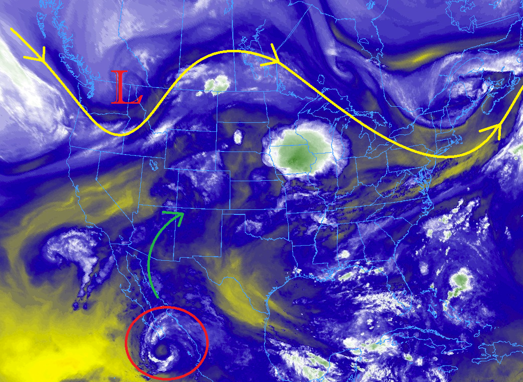
The water vapor imagery below can tell us a lot about the upcoming weather situation, and I have highlighted the main features. The first thing that jumps off the page is circled in red. Formerly Hurricane Bud (now Tropical Storm Bud) is moving nearly due-northward, with its outflow moisture already being pulled into Colorado (as indicated by the green arrow). The upper-level low currently centered over the Pacific NW will continue to dig southward towards the Great Basin, enhancing the fetch of moisture from the Pacific into the 4-corners region. These features all set the stage for the High Flood Threat (Event #1) of Friday, June 15th to Sunday, June 17th.
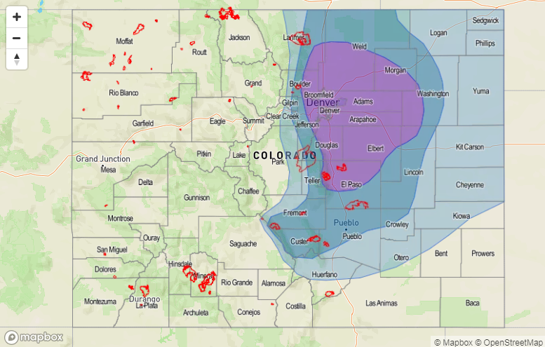
Event #1: Friday (06-15-2018) through Sunday (06-17-2018): High Flood Threat
The remnants of Hurricane Bud are the main concern behind the High Flood Threat, as the moisture associated with it will push pockets of precipitable water values over an inch across much of Colorado beginning late Friday, and then becoming more widespread by Saturday afternoon through Sunday. One inch of precipitable water sets off alarm bells due to the precipitation efficiency it promotes from showers and thunderstorms. It will not take much instability to produce moderate-to-heavy rainfall under conditions such as these.
The Burro Fire and 416 Fire burn areas are of the most concern during this event for a few reasons: 1) They are recent/ongoing – soil has had no time to recover at all, making them highly susceptible to flash flooding, mud flows, and debris slides, 2) They are favorably positioned on the south/southwest facing slopes of the San Juan Mountains, which are expected to be the most heavily impacted by rainfall during this event, and 3) Rain rates as low as 0.25-0.5 inches/hour will be sufficient to produce the aforementioned threats in, and downstream of, these burn scars. Other High Country burn scars should be monitored, as well (including those in the Southeast Mountains).
Storm Motions, Rain Rates, and Prime Time:
- The main threat period will be from 6 AM Saturday until Noon on Sunday, with the primetime being Noon to Midnight on Saturday. This is when the best moisture, instability, and upper-level support will coincide.
- Storms will generally move in a north-northeastward direction at 15-25 mph
- It is a bit premature to be talking rain rates, due to the primetime of the event still being 48 hours or so away. At this time, 1-hour rain rates greater than 0.25 inches/hour are likely over the burn scars. Be sure to pay close attention to the daily FTB for up-to-date and more specific information.
- This event will be more of a 24-hour event than a 1-hour event. Most 24 hour totals will be in the 0.25-0.5 inch range, but localized 24-hour totals through Sunday morning of 1.0-1.25 inches will be possible. Totals for the entire event over the San Juan Mountains will be 1-2 inches, with localized areas receiving 2-2.25 inches. These higher totals are currently forecast to fall east of the burn scars as long as Bud maintains his current track. Again, please stay up-to-date with the daily FTB for changes to this forecast.
Drier air will begin to move into western Colorado on Sunday afternoon, but enough moisture will likely hang on for scattered showers/thunderstorms over the area.
Saturday and Sunday will be the main days for shower/thunderstorm activity for eastern Colorado associated with Event #1, as subtropical moisture increases the chances for wetting rainfall and low-level moisture recovers. A frontal passage on Sunday will bring upslope flow to the Front Range and Urban Corridor, so those areas will need to be monitored through the weekend. Eastern Colorado’s main event will be Event #2.
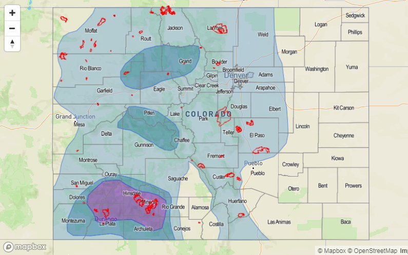

Event #2: Monday (06-18-2018) through Friday (06-22-2018): Elevated Flood Threat
Event #2 will immediately follow Event #1, as the upper-level low that set the stage for Event #1 becomes cut-off from the main flow regime, and “stalls” and gradually weakens over the Great Basin for the better part of the work week. This will result in a few days of continuous subtropical moisture pull into eastern Colorado, as well as low-level moisture from the east thanks to the development of a lee-side trough/surface low. Upslope flow, instability, and plenty of moisture will be present to produce daily rounds of thunderstorms capable of heavy rainfall from the Front Range/Southeast Mountains eastward, with the bulk of the activity occurring north of Highway 50. West of the Continental Divide, the low-levels will be too dry to result in much wetting rainfall, but with the recent heavy rain from Event #1, they will still need to be watched for any short-term flood threats that may develop.