FTO 07-02-2018: Elevated Flood Threat for the 4th of July Holiday

Issue Date: Monday, July 2nd, 2018
Issue Time: 2:30PM MDT
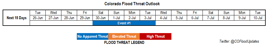
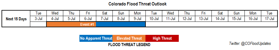
Valid Dates: 7/3– 7/17

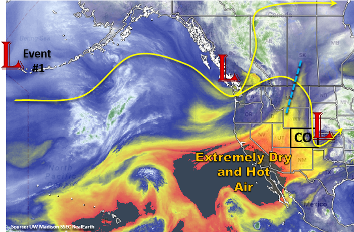
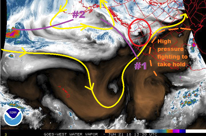
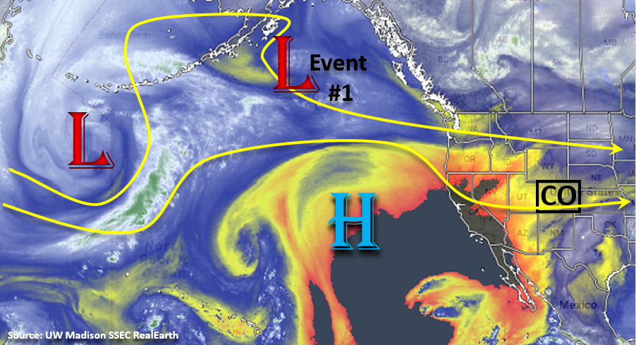
On and off thunderstorm activity will mark this next FTO period while Colorado remains under a ridging pattern. This strong ridge will keep the jet stream and upper level disturbances well to the north of Colorado, which will limit shower and thunderstorm activity to the afternoons and evenings. As these upper systems move north of Colorado, they will drop a couple of cold fronts, which will help moisten the lower atmosphere for afternoon showers and thunderstorms. Depending on the placement of the ridge axis, Colorado’s chances for afternoon rainfall either increases or decreases. The placement of the ridge determines where the moisture can return for the terrain induced showers and thunderstorms. Thus, the on and off nature of the thunderstorm threat as the ridge axis shifts  throughout the week. There is only one event for this FTO forecast period due to high uncertainty in regards to moisture return after this weekend.

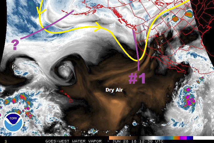
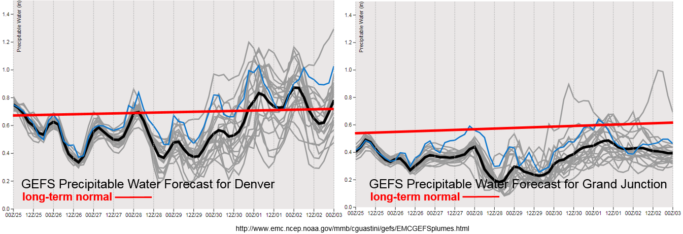
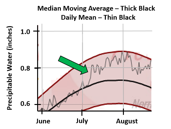
The beginning of July is marked by a strong increase in the daily mean Precipitable Water (PW) climatology. This sharp jump is marked in the Denver sounding climatology with the green arrow below (source: SPC). The median moving average goes from about 0.7 inches to just over 0.8 inches in about a week’s time and can also be seen in Grand Junction’s climatology. This sudden shift is important to note as it marks the beginning of increased moisture seen during the monsoon season. When this higher moisture is present, the chances for heavy rainfall and flooding increases as rainfall rates become more efficient. Slow steering winds under the monsoon regime (ridging pattern) also increase the chances for flooding as more rainfall can fall over one area.  Thus, beginning after July, extra attention is paid to a model’s PW values and upper disturbances in the water vapor imagery as they often mark when there is an increased flood threat. It’s still a bit early for monsoonal flow to reach Colorado, but model forecasts and wind shifts will be monitored closely for trends during each long-range forecast.

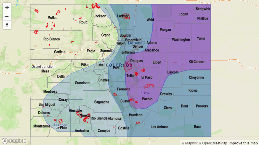
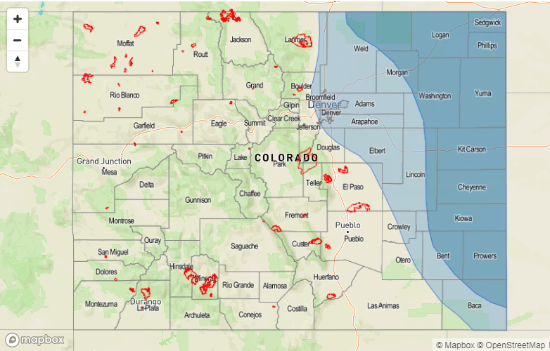
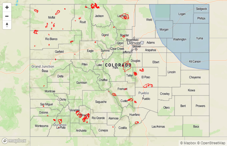
PW values east of the Continental Divide show a bit more moisture on Wednesday through Friday before it begins to taper off a bit as the ridge shifts east. Wednesday, a cold front will slide through the northern portion of the state, which will allow for better low-level moisture for thunderstorms as they form with upslope flow during the afternoon. Between the boundary, high CAPE and decent shear, some severe thunderstorms are possible over the eastern plains during the late afternoon and evening. Residual moisture and strong southerly flow pulling in Gulf of Mexico moisture over the eastern plains will keep the area under an elevated flood threat through Friday night. Sunday morning, another cold front is forecast to pass over the northern portion of the state, which would increase the chances for showers and thunderstorms over the Front Range and Urban Corridor. At this time the atmosphere appears to remain capped over the eastern plains.

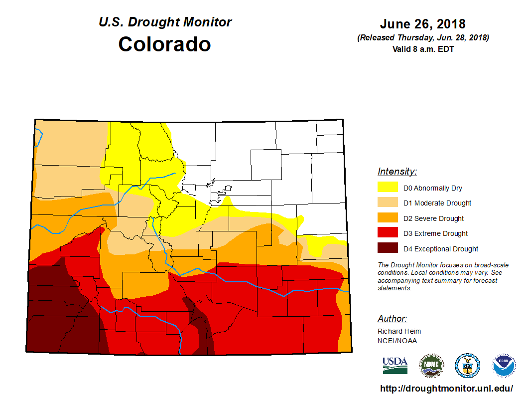
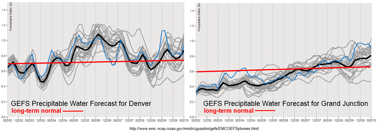
In Western Colorado, moisture begins to creep up from the subtropics throughout the week as the ridge axis shifts from west to east. Models hint at some subtropical moisture reaching the southwest corner of the state Friday and continuing to increase throughout the weekend. While the highest PW values will likely remain west of Colorado, PW values in the 0.8 inch range would bring measurable rainfall to the San Juan Mountains. If this moisture is realized, rain rates greater than 0.25 inches/hour are possible, which could bring mud flows, debris slides and flash flooding to the burn scars in the southwest mountains. At this time, uncertainty is high, so please check back to the FTO on Thursday afternoon for an update.

Below we describe the one identified precipitation event of this FTO in more detail.

Event #1: Wednesday (7/4) – Monday (7/9)

Elevated/No Apparent Threat for daily, terrain induced thunderstorms under the ridging pattern.

As mentioned above, the best chance for heavy rainfall east of the Divide will occur from Wednesday to Friday night. With the ridge axis a bit to the west of Colorado, southerly flow will pull in high moisture from the Gulf of Mexico to the eastern plains. Wednesday, the passage of a cold front will help increase low-level moisture over the northeast corner of the state and will increase the chances for heavier rainfall along the Front Range and Urban Corridor. This will also be the day where severe weather chances will be greatest over the eastern plains. The main threats will be severe hail and strong winds, with increased convergence along the stalled out front over the Palmer Divide. Front Range rainfall chances increase again on Sunday as another cold front moves through northern Colorado. All afternoon convection is expected to be terrain driven during this period, so there are no overnight threats at this time.

West of the Divide, subtropical moisture slowly increases throughout the week as the ridge axis shifts eastward. Right now it looks like the ridge does not migrate northward enough to mark the beginning of 2018 monsoonal flow. There is also not a lot of confidence as to how high the PW values will reach over the southwest corner of the state or where the moisture axis will set up. However, if PW values are able to increase to 0.8 inches, as indicated by the GEFS, rain rates greater than 0.25/hour would be possible. This would bring measurable rainfall to the San Juan Mountains and fires, but may also cause mud flows, debris slides and flash flooding over the burn scars. As mentioned, confidence is low so there is No Apparent Threat at this time. Please check back to Thursday’s FTO for more details.


Legend

FTO 06-28-2018: Strong Summer Ridging Fighting Against Drought Relief

Issue Date: 6/28/2018
Issue Time: 9:50 AM

There is not much relief in this FTO period for the worsening drought across Colorado, as high-pressure ridging will be in place more often than not throughout the period. Before we dive into the forecast, let’s take stock of just exactly where the drought stands currently. Southern Colorado continue to be in the worst shape, with much of the southern half of the state experiencing Severe-to-Exceptional Drought. The overall percentage breakdown for Colorado looks like this: 66.9% of the state is under at least Moderate Drought, with 27.65% of the state in Extreme Drought and 8.81% under Exceptional Drought.

Event #1 is characterized by a quickly passing upper-level trough, highlighted in the water vapor image below (purple #1). The upper-level trough will be enough to dislodge the strong ridge bringing our current record heat to the east and allow cooler temperatures and a bit of moisture to return. Unfortunately, the moisture return will not be enough to result in widespread rainfall. Instead, much of the isolated-to-scattered showers/thunderstorm activity will be confined along/east of the Continental Divide, with a couple stronger thunderstorms over the eastern plains. Low-level moisture will remain insufficient to generate heavy rainfall, but stronger thunderstorms near the CO/KS/NE border will have enough to muster brief periods of moderate, wetting rainfall.

After Event #1 exits the region by Sunday, upper-level high pressure will once again fight to regain its hold over Colorado, with another warming and drying trend expected for July 1st – July 9th. Typical of the Colorado summertime, isolated daily afternoon/evening thunderstorms over/near the mountains will be possible, owing to daytime heating and orographic effects working on any moisture that may be available. One potential caveat to this overall dry period comes in the way of the upper-level trough noted on the water vapor image, denoted by the purple “?”. Currently, it appears this trough will be thwarted by the strong high-pressure centered over Colorado, brushed off towards the northern Rockies. This will be an important feature to watch, as it could add an additional event to next week, and bring some much needed rainfall to the state, if it is able to overcome the ridge just enough.

Event #2 finally comes around late in the period, beginning late on Tuesday, July 10th, and continuing through Friday, July 13th. The upper-level ridge axis will shift west of the state, bringing cooler northwest flow aloft into the region. This will likely push a surface cool front or two through the state from north to south, with low-level moisture accompanying such frontal passages, and upslope flow, east of the Continental Divide. Due to this event being more than 10 days out, uncertainty is high, and no flood threat highlights can be confidently determined. Instead, we will continue to watch this time frame and provide an update in the FTO on Monday.

Event #1: Friday (06-29-2018) through Saturday (06-30-2018)

No Apparent Threat from Passing Upper-Level Low

A quickly passing upper-level trough is the culprit behind Event #1, but a lack of moisture in place will cut its potential rainfall impact off at the knees. Isolated-to-scattered high-based showers/thunderstorms are expected along/east of the Continental Divide, with a few strong-to-severe thunderstorms over the eastern plains. The main threats from storm activity will be strong winds and small hail, with brief periods of wetting rainfall near the eastern CO border. No areas will receive greater than 0.5 inches of rainfall, thus no precipitation map has been drawn.

Event #2: Tuesday (07-10-2018) through Friday (07-13-2018)

No Apparent Threat due to High Uncertainty

Due to this event taking shape more than 10 days out from now, uncertainty is high regarding any specific outcomes, so no precipitation map or flood threat highlights will be given. Currently, this event looks to be driven by northwest flow aloft and a couple surface frontal passages, with the return of low-level moisture accompanying upslope flow. This event looks to be the best shot at good, widespread rainfall, mainly east of the Continental Divide, during this 15-day FTO period. We will continue to monitor this time frame, and an update will be given in Monday’s FTO.

FTO 06-25-2018: Post Summer Solstice Heat Wave

Issue Date: Monday, June 25th, 2018
Issue Time: 12:15PM MDT
Valid Dates: 6/26 – 7/10

Perfect timing for the first heat wave of the astronomical summer as the solstice occurred on June 21st. The upper level trough over Kansas that brought widespread showers and thunderstorms to eastern Colorado on Sunday will continue its eastward track throughout the day. Behind the trough, a ridge (marked in blue below) will begin to slide in from the east and build through Friday. This will help bring quite the heat wave to the state starting on Tuesday. The very dry and hot air is marked in the water vapor imagery below (large area of dark orange and black shades). Temperatures are forecast to reach 100F over the Southeast Plains starting Tuesday with the most widespread high temperatures occurring Thursday afternoon. Expect most of the lower elevations to hit 100F or right below that mark on Thursday. The strong ridge should keep the upper low currently situated near the Pacific Northwest well to the north of Colorado. At the end of this week, a trough will move over the Great Basin, which begins the one and only flood threat of this FTO (Event #1).

Dry, hot air under the ridge will limit the chances of afternoon rainfall during the work week. The PW plumes below show a bit more moisture on Tuesday on Wednesday before they drop well below average. This will allow some scattered cloud cover each afternoon over the higher terrains. By Thursday afternoon, the moisture is quite low, so don’t expect much cloud cover to help with the high temperatures. After Thursday, PW values begin to increase with the approaching trough. The spread between the runs (gray lines) signifies there is little confidence with how much moisture will accompany the next system. However, confidence is higher that heavy rainfall will not occur (especially west of the Continental Divide) as very few models reach 1 inch of PW. Some higher moisture may be able to wrap around the backside of the ridge over the eastern plains, but it is still a bit too far out to forecast this accurately. Thus, there is No Apparent Flood Threat at this time.

After Event #1 a ridge begins to build over the state again, and with the axis to our west, this should limit our chances of heavy rainfall. However, it won’t be long until the monsoon pattern sets up and begins to pull in the subtropical moisture to Colorado under the ridge. The GFS has started hinting at this pattern change at the tail end of this outlook. Below we describe the one identified precipitation event of this FTO in more detail.

Event #1: Saturday (6/30) – Tuesday (7/3)

No Apparent Threat as the next trough slides into the Great Basin and promotes more widespread shower and thunderstorm activity to start the weekend.

After a long hot and dry week, a trough is forecast to move into the Great Basin on Friday. With PW values forecast to be well below average over western Colorado, the strong gradient (upper jet stream) may bring critical fire weather back to the area on Friday and Saturday. Light rainfall may occur over the higher terrains, but dry thunderstorms and gusty winds are the more likely scenario. These storms will be extra hazardous as high temperatures throughout this week will continue to dry out the already dehydrated ground cover. We will continue to keep you informed about Red Flag Warnings each day in the FTB.

East of the Divide, a bit more moisture is able to return to Colorado. Thus, there is better opportunity for measurable rainfall as the trough passes through the state on Saturday and Sunday. The best chance for measurable, more extensive rainfall will be Saturday with the passage of a weak cold front and extra upper level lift from the trough. If high moisture is able to sneak into the state over the eastern plains, this area has the best chance for the highest accumulations. At this time, flooding criteria is not expected to be met on Saturday or Sunday. Residual moisture under the ridge on Monday and Tuesday will help spark more isolated showers and thunderstorms during the afternoon over the higher terrains.

Legend

FTO 06-21-2018: A Battle Between an Upper-Level Ridge and Multiple Disturbances

Issue Date: Thursday, June 21st, 2018
Issue Time: 11:35 AM MDT
Valid Dates: 06/22/2018 – 07/06/2018

This FTO period is best described as a battle between summertime ridging over the southern/central United States and disturbances aloft set on flattening the ridge. Circled in red is the disturbance that is impacting Colorado today, and will be east of the state by tomorrow. It has the important role of setting the stage for Event #1, marked by the purple line and “#1” in the water vapor image below. The short-term flattening of the ridge by today’s disturbance will make it easier, so to speak, for the following disturbance to reach southward across Colorado, impacting the state from Friday-Sunday (June 22nd – June 25th), with the prime of the period being Saturday and Sunday. Broad-scale support aloft will overlay an increase in low-level moisture from the east, leading to the threat of strong thunderstorms and heavy rainfall. Thus, the event will be categorized as an Elevated Flood Threat, mainly for areas along and east of the I-25 corridor.

After Event #1, the high pressure ridge will assert a bit of dominance, allowing Colorado to dry out and warm up, but daily thunderstorms over/near the higher terrain will likely continue as daytime heating works on residual moisture. This activity looks to be more wind than rain, as is typical of mountain thunderstorms under a ridge during the Colorado summertime.

Event #2 (June 29th-July 1st) does not look like much about which to write home at the present time. This edition of the high pressure ridge is a bit more robust than today’s version, and will fight to keep the disturbance north of Colorado. Enough lift will be able to reach southward into Colorado, however, and a couple of days of isolated-to-scattered thunderstorms are likely. The strongest storms during this period will be over the eastern plains, where better moisture and instability will be in place. We will be keeping a close eye on Event #2 in the coming days, monitoring whether the moisture return will be better than expected, and whether or not the disturbance can put a bigger dent in the upper-level ridge. Once Event #2 has come and gone, the remainder of this FTO period looks to be hot and dry under the influence of strong high pressure aloft.

Event #1: Friday (06-22-2018) through Monday (06-25-2018)

Elevated Flood Threat as Upper-Level Disturbance Makes Use of Low-Level Moisture

The approach and passage of an upper-level disturbance/closed low will result in a few days of scattered showers and thunderstorms. Broad-scale support will overlay good moisture, especially along/east of the I-25 corridor, where strong-to-severe thunderstorms will be capable of heavy rainfall in short periods of time. Saturday and Sunday are the height of the flood threat during this 4-day event.

Legend

Event #2: Friday (06-29-2018) through Sunday (07-01-2018)

No Apparent Threat as the High Pressure Ridge Fights the Disturbance

Strong high pressure over the Southern and Central US will fight to keep dry, subsident air in place over Colorado during the period as an upper-level disturbance attempts to tamp it down. High pressure will win out, for the most part, as only weak lift will reach southward into Colorado. A couple days of isolated-to-widely scattered storms will be the result, with a relative lack of moisture keeping the heavy rainfall threat at bay. We will continue to monitor this time frame, so be sure to check back in on Monday’s FTO.

Legend