Issue Date: Monday, June 25th, 2018
Issue Time: 12:15PM MDT
Valid Dates: 6/26 – 7/10

Perfect timing for the first heat wave of the astronomical summer as the solstice occurred on June 21st. The upper level trough over Kansas that brought widespread showers and thunderstorms to eastern Colorado on Sunday will continue its eastward track throughout the day. Behind the trough, a ridge (marked in blue below) will begin to slide in from the east and build through Friday. This will help bring quite the heat wave to the state starting on Tuesday. The very dry and hot air is marked in the water vapor imagery below (large area of dark orange and black shades). Temperatures are forecast to reach 100F over the Southeast Plains starting Tuesday with the most widespread high temperatures occurring Thursday afternoon. Expect most of the lower elevations to hit 100F or right below that mark on Thursday. The strong ridge should keep the upper low currently situated near the Pacific Northwest well to the north of Colorado. At the end of this week, a trough will move over the Great Basin, which begins the one and only flood threat of this FTO (Event #1).
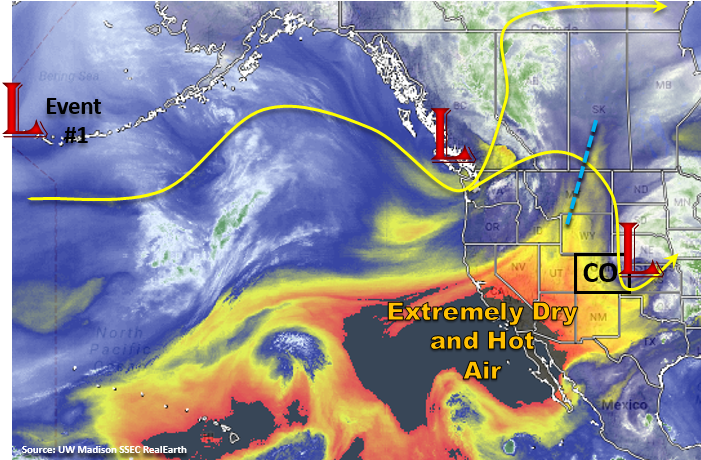
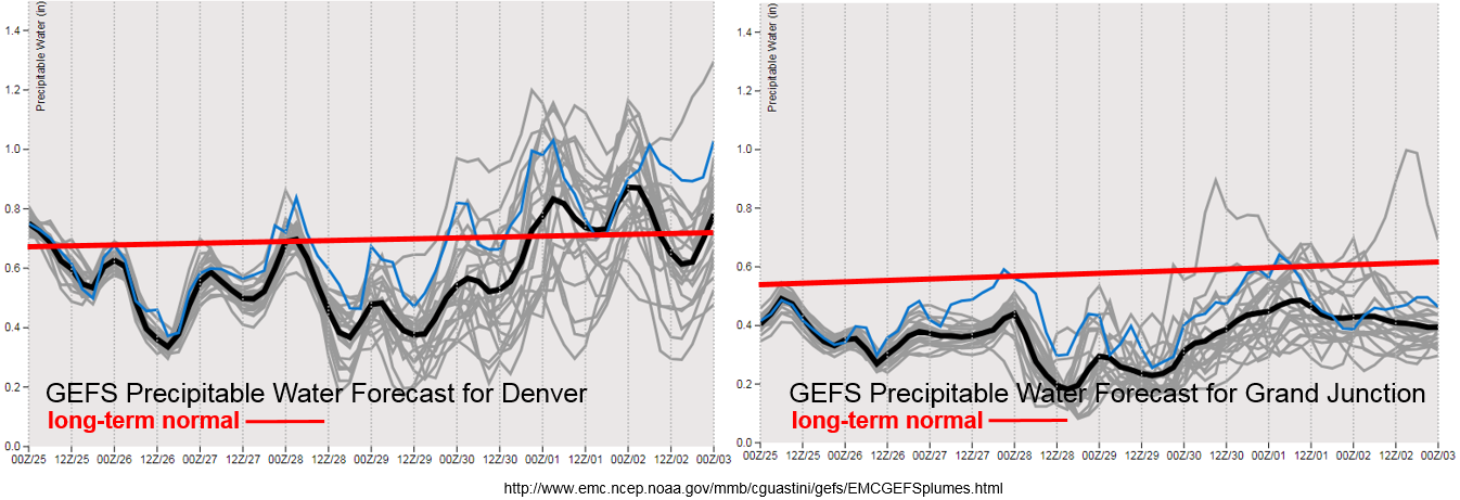
Dry, hot air under the ridge will limit the chances of afternoon rainfall during the work week. The PW plumes below show a bit more moisture on Tuesday on Wednesday before they drop well below average. This will allow some scattered cloud cover each afternoon over the higher terrains. By Thursday afternoon, the moisture is quite low, so don’t expect much cloud cover to help with the high temperatures. After Thursday, PW values begin to increase with the approaching trough. The spread between the runs (gray lines) signifies there is little confidence with how much moisture will accompany the next system. However, confidence is higher that heavy rainfall will not occur (especially west of the Continental Divide) as very few models reach 1 inch of PW. Some higher moisture may be able to wrap around the backside of the ridge over the eastern plains, but it is still a bit too far out to forecast this accurately. Thus, there is No Apparent Flood Threat at this time.
After Event #1 a ridge begins to build over the state again, and with the axis to our west, this should limit our chances of heavy rainfall. However, it won’t be long until the monsoon pattern sets up and begins to pull in the subtropical moisture to Colorado under the ridge. The GFS has started hinting at this pattern change at the tail end of this outlook. Below we describe the one identified precipitation event of this FTO in more detail.
Event #1: Saturday (6/30) – Tuesday (7/3)
No Apparent Threat as the next trough slides into the Great Basin and promotes more widespread shower and thunderstorm activity to start the weekend.
After a long hot and dry week, a trough is forecast to move into the Great Basin on Friday. With PW values forecast to be well below average over western Colorado, the strong gradient (upper jet stream) may bring critical fire weather back to the area on Friday and Saturday. Light rainfall may occur over the higher terrains, but dry thunderstorms and gusty winds are the more likely scenario. These storms will be extra hazardous as high temperatures throughout this week will continue to dry out the already dehydrated ground cover. We will continue to keep you informed about Red Flag Warnings each day in the FTB.
East of the Divide, a bit more moisture is able to return to Colorado. Thus, there is better opportunity for measurable rainfall as the trough passes through the state on Saturday and Sunday. The best chance for measurable, more extensive rainfall will be Saturday with the passage of a weak cold front and extra upper level lift from the trough. If high moisture is able to sneak into the state over the eastern plains, this area has the best chance for the highest accumulations. At this time, flooding criteria is not expected to be met on Saturday or Sunday. Residual moisture under the ridge on Monday and Tuesday will help spark more isolated showers and thunderstorms during the afternoon over the higher terrains.