Issue Date: 6/28/2018
Issue Time: 9:50 AM

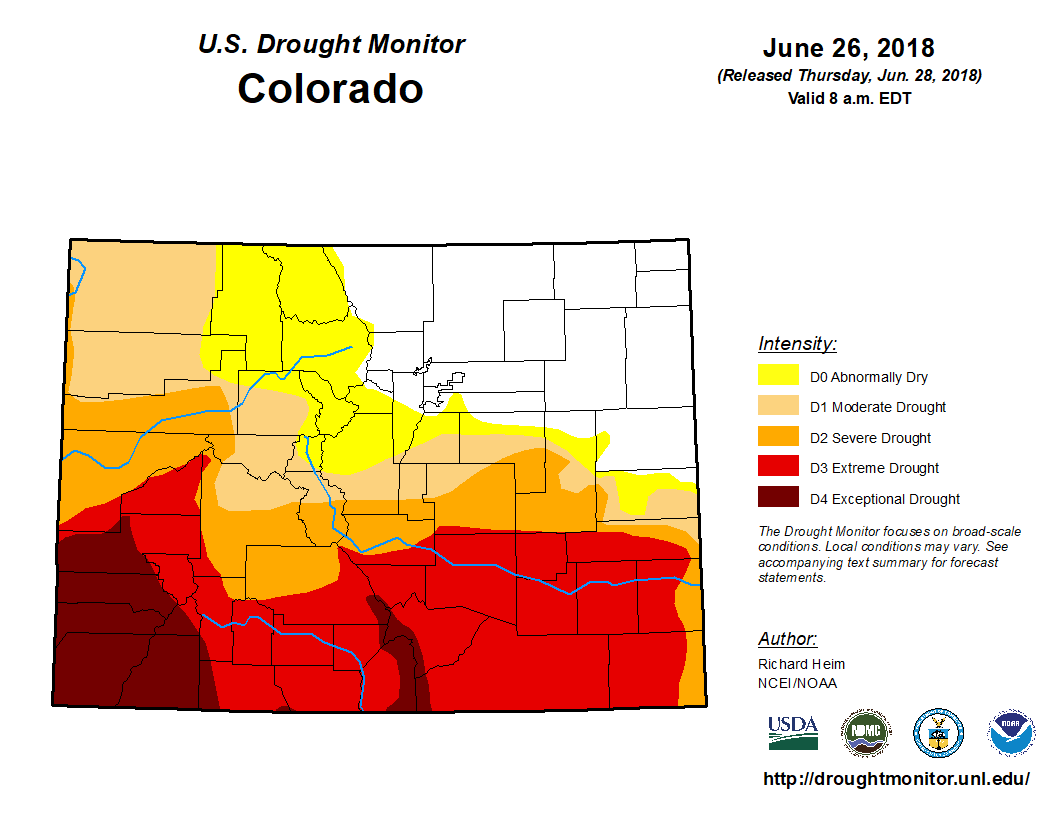
There is not much relief in this FTO period for the worsening drought across Colorado, as high-pressure ridging will be in place more often than not throughout the period. Before we dive into the forecast, let’s take stock of just exactly where the drought stands currently. Southern Colorado continue to be in the worst shape, with much of the southern half of the state experiencing Severe-to-Exceptional Drought. The overall percentage breakdown for Colorado looks like this: 66.9% of the state is under at least Moderate Drought, with 27.65% of the state in Extreme Drought and 8.81% under Exceptional Drought.
Event #1 is characterized by a quickly passing upper-level trough, highlighted in the water vapor image below (purple #1). The upper-level trough will be enough to dislodge the strong ridge bringing our current record heat to the east and allow cooler temperatures and a bit of moisture to return. Unfortunately, the moisture return will not be enough to result in widespread rainfall. Instead, much of the isolated-to-scattered showers/thunderstorm activity will be confined along/east of the Continental Divide, with a couple stronger thunderstorms over the eastern plains. Low-level moisture will remain insufficient to generate heavy rainfall, but stronger thunderstorms near the CO/KS/NE border will have enough to muster brief periods of moderate, wetting rainfall.
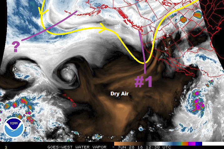
After Event #1 exits the region by Sunday, upper-level high pressure will once again fight to regain its hold over Colorado, with another warming and drying trend expected for July 1st – July 9th. Typical of the Colorado summertime, isolated daily afternoon/evening thunderstorms over/near the mountains will be possible, owing to daytime heating and orographic effects working on any moisture that may be available. One potential caveat to this overall dry period comes in the way of the upper-level trough noted on the water vapor image, denoted by the purple “?”. Currently, it appears this trough will be thwarted by the strong high-pressure centered over Colorado, brushed off towards the northern Rockies. This will be an important feature to watch, as it could add an additional event to next week, and bring some much needed rainfall to the state, if it is able to overcome the ridge just enough.
Event #2 finally comes around late in the period, beginning late on Tuesday, July 10th, and continuing through Friday, July 13th. The upper-level ridge axis will shift west of the state, bringing cooler northwest flow aloft into the region. This will likely push a surface cool front or two through the state from north to south, with low-level moisture accompanying such frontal passages, and upslope flow, east of the Continental Divide. Due to this event being more than 10 days out, uncertainty is high, and no flood threat highlights can be confidently determined. Instead, we will continue to watch this time frame and provide an update in the FTO on Monday.
Event #1: Friday (06-29-2018) through Saturday (06-30-2018)
No Apparent Threat from Passing Upper-Level Low
A quickly passing upper-level trough is the culprit behind Event #1, but a lack of moisture in place will cut its potential rainfall impact off at the knees. Isolated-to-scattered high-based showers/thunderstorms are expected along/east of the Continental Divide, with a few strong-to-severe thunderstorms over the eastern plains. The main threats from storm activity will be strong winds and small hail, with brief periods of wetting rainfall near the eastern CO border. No areas will receive greater than 0.5 inches of rainfall, thus no precipitation map has been drawn.
Event #2: Tuesday (07-10-2018) through Friday (07-13-2018)
No Apparent Threat due to High Uncertainty
Due to this event taking shape more than 10 days out from now, uncertainty is high regarding any specific outcomes, so no precipitation map or flood threat highlights will be given. Currently, this event looks to be driven by northwest flow aloft and a couple surface frontal passages, with the return of low-level moisture accompanying upslope flow. This event looks to be the best shot at good, widespread rainfall, mainly east of the Continental Divide, during this 15-day FTO period. We will continue to monitor this time frame, and an update will be given in Monday’s FTO.