Issue Date: Thursday, June 21st, 2018
Issue Time: 11:35 AM MDT
Valid Dates: 06/22/2018 – 07/06/2018

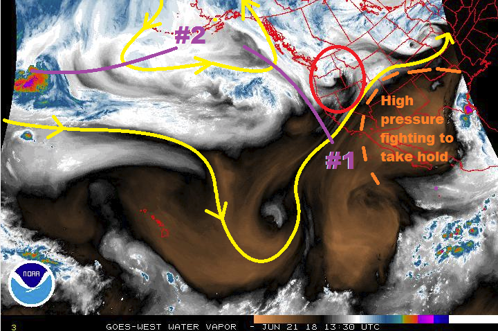
This FTO period is best described as a battle between summertime ridging over the southern/central United States and disturbances aloft set on flattening the ridge. Circled in red is the disturbance that is impacting Colorado today, and will be east of the state by tomorrow. It has the important role of setting the stage for Event #1, marked by the purple line and “#1” in the water vapor image below. The short-term flattening of the ridge by today’s disturbance will make it easier, so to speak, for the following disturbance to reach southward across Colorado, impacting the state from Friday-Sunday (June 22nd – June 25th), with the prime of the period being Saturday and Sunday. Broad-scale support aloft will overlay an increase in low-level moisture from the east, leading to the threat of strong thunderstorms and heavy rainfall. Thus, the event will be categorized as an Elevated Flood Threat, mainly for areas along and east of the I-25 corridor.
After Event #1, the high pressure ridge will assert a bit of dominance, allowing Colorado to dry out and warm up, but daily thunderstorms over/near the higher terrain will likely continue as daytime heating works on residual moisture. This activity looks to be more wind than rain, as is typical of mountain thunderstorms under a ridge during the Colorado summertime.
Event #2 (June 29th-July 1st) does not look like much about which to write home at the present time. This edition of the high pressure ridge is a bit more robust than today’s version, and will fight to keep the disturbance north of Colorado. Enough lift will be able to reach southward into Colorado, however, and a couple of days of isolated-to-scattered thunderstorms are likely. The strongest storms during this period will be over the eastern plains, where better moisture and instability will be in place. We will be keeping a close eye on Event #2 in the coming days, monitoring whether the moisture return will be better than expected, and whether or not the disturbance can put a bigger dent in the upper-level ridge. Once Event #2 has come and gone, the remainder of this FTO period looks to be hot and dry under the influence of strong high pressure aloft.
Event #1: Friday (06-22-2018) through Monday (06-25-2018)
Elevated Flood Threat as Upper-Level Disturbance Makes Use of Low-Level Moisture
The approach and passage of an upper-level disturbance/closed low will result in a few days of scattered showers and thunderstorms. Broad-scale support will overlay good moisture, especially along/east of the I-25 corridor, where strong-to-severe thunderstorms will be capable of heavy rainfall in short periods of time. Saturday and Sunday are the height of the flood threat during this 4-day event.

Event #2: Friday (06-29-2018) through Sunday (07-01-2018)
No Apparent Threat as the High Pressure Ridge Fights the Disturbance
Strong high pressure over the Southern and Central US will fight to keep dry, subsident air in place over Colorado during the period as an upper-level disturbance attempts to tamp it down. High pressure will win out, for the most part, as only weak lift will reach southward into Colorado. A couple days of isolated-to-widely scattered storms will be the result, with a relative lack of moisture keeping the heavy rainfall threat at bay. We will continue to monitor this time frame, so be sure to check back in on Monday’s FTO.