FTO 05-09-2019: Scattered Showers for Southern Colorado then Warm Weather Returns for the Weekend

Issue Date: Thursday, May 9th, 2019
Issue Time: 12:15PM MDT
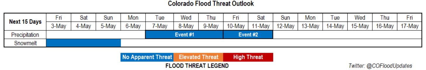
Valid Dates: 5/10 – 5/24

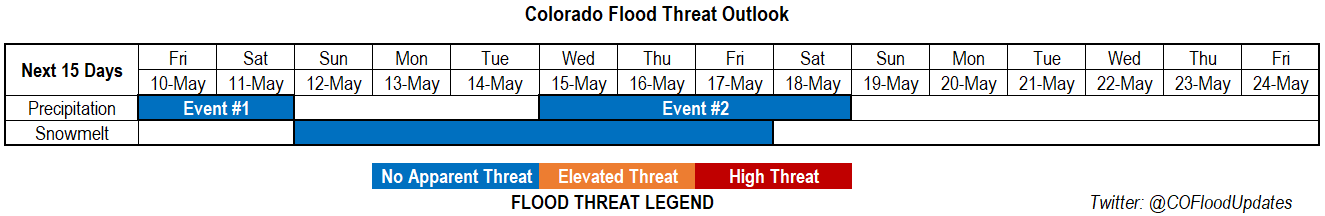
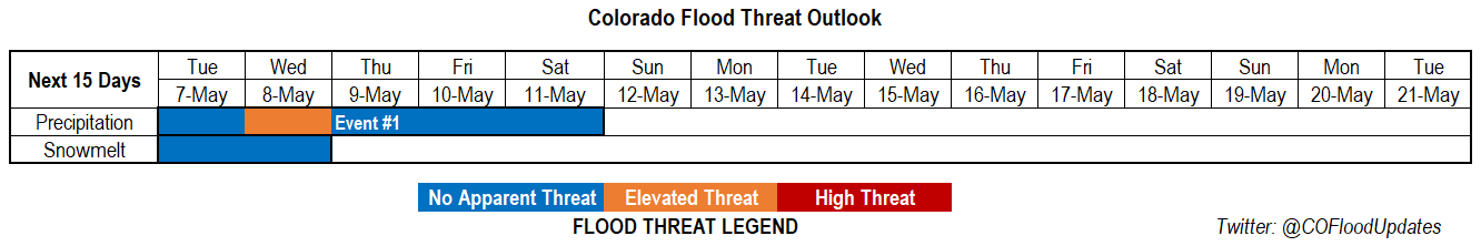
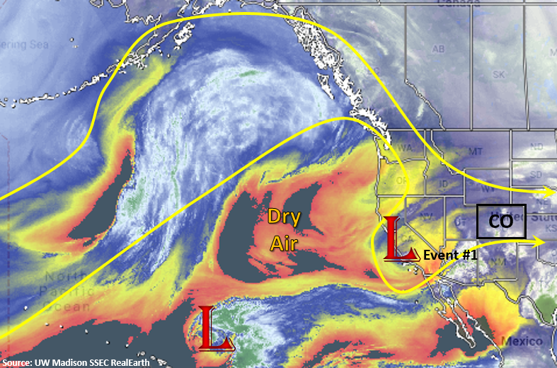
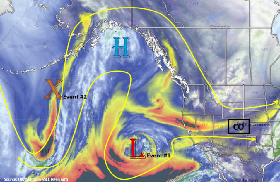
We start this FTO with the tail end of Event #1 from Monday’s FTO. Currently, a trough is exiting eastern Colorado with a break before the next wave moves in from AZ/UT/NV. This means flow aloft will turn to southwesterly to westerly on Friday. A plume of moisture, marked in the water vapor imagery below, will be pulled into southern Colorado. This will help fuel some snowfall and rain (lower elevations) over southern Colorado along the CO/NM border tonight into Friday morning. Expecting showers to continue tomorrow afternoon before the trough pulls westward and digs south creating a cutoff upper level low off the coast of CA.


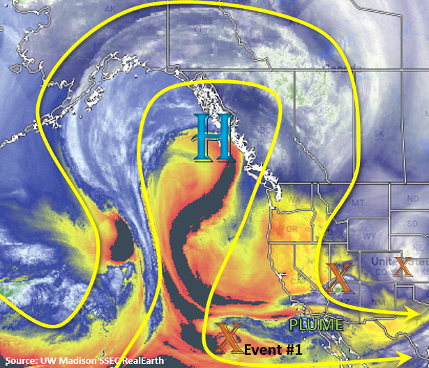
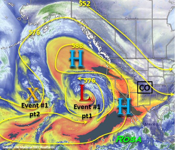
Below is the 500mb geopotential height anomaly from the GEFS (Global Ensemble Forecast System) on Saturday morning. It very nicely illustrates the low becoming cutoff from the main, westerly flow. Once the system is cutoff, it moves south and slowly wanders east (Saturday-Tuesday). It should stay far enough south that it won’t affect the state. On Friday, high pressure starts to build over the state and a weak cold front gives the winds more of a northerly component on Saturday afternoon. This should prevent widespread showers as only minimal moisture remains trapped under the building ridge. Expect scattered storms over the San Juan Mountains with limited rainfall over the other high elevations. With high pressure to the north and low pressure to the south by Sunday, a nice a rex blocking pattern should keep the weather calm into next week. Warm temperatures will also be back in the forecast, so expecting widespread melting of the snowpack between the two systems. High temperatures over the lower elevations will start climbing towards 70°F by Sunday, and they be well into the 70°Fs on Monday and Tuesday.

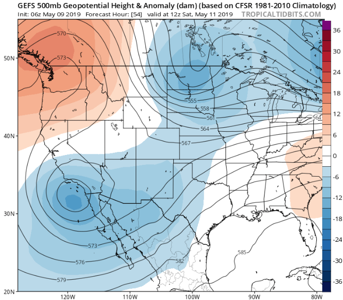
Event #2 begins sometime between Wednesday and Thursday of next week. The next trough slides over the west coast and pushes the ridge eastward. Details of this event are still a little bit out, but right now the best moisture and dynamics don’t move into the state until Thursday or Friday. At this time there is No Apparent Threat; however, some severe weather may be likely towards the end of next week.

Event #1: Friday (5/10) – Saturday (5/11)

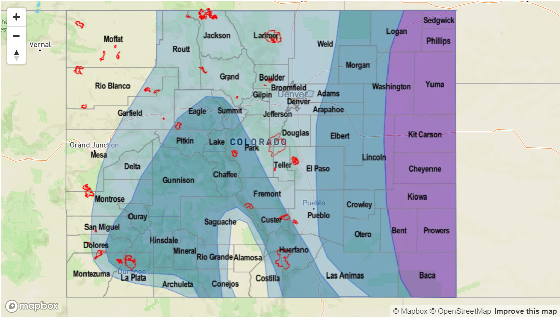
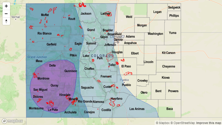
No Apparent Threat as the cutoff low moves south and westward of the state. The current wave over UT/AZ/NV will help provide lift and moisture for scattered storms across the southern border of the state into Friday morning.

With the next wave moving into Colorado this afternoon and tonight, the chances for rainfall will be greatest over the southern border. Light showers and snow accumulation are likely over these higher terrains by tomorrow morning. As the ridge begins to build over the state, some residual moisture on Saturday may help initiate some storms over the San Juan Mountains. Without a ton of moisture under the building ridge, totals should be much less than the last couple of days. Highest totals are forecast over the western facing slopes in the San Juan Mountains with lighter totals over the Southeast Mountains and Raton Ridge. Flooding is not expected.


Legend

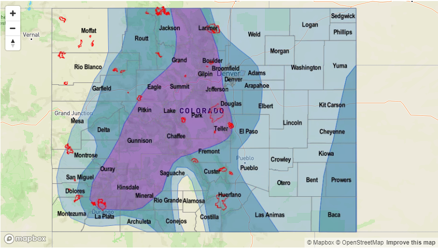
Event #2: Wednesday (5/15) – Saturday (5/18)

No Apparent Threat as the next trough moves over the west coast and pushes the ridge east.

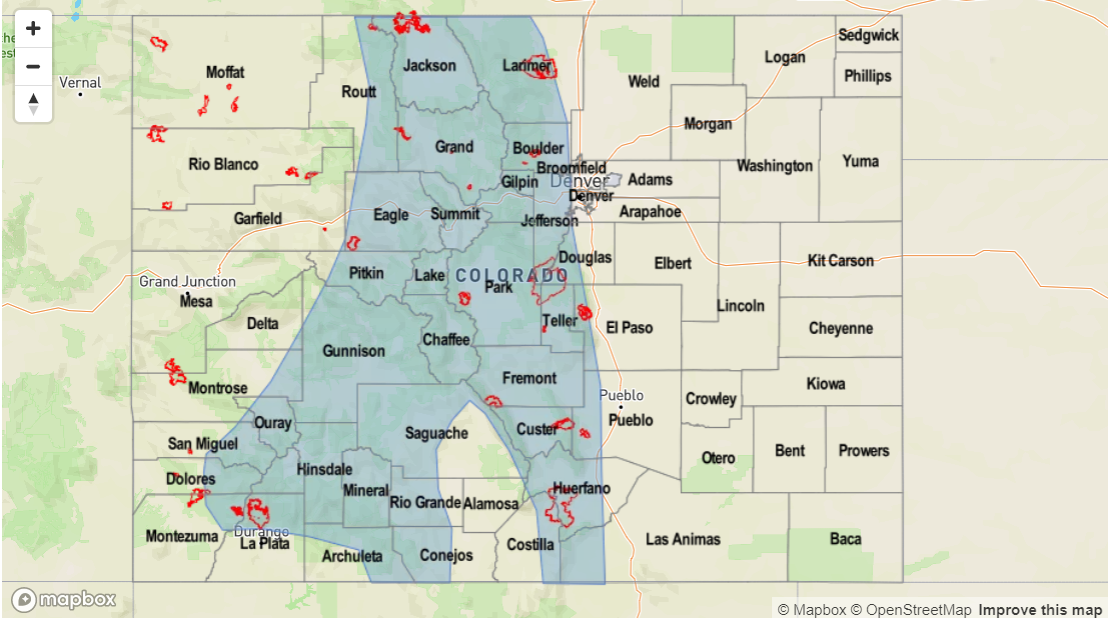
Not a lot of confidence in the details of this next pattern, but storms look to return to the forecast towards mid/end of next week. Best dynamics and moisture will likely arrive when a cold front drops south. Right now the GFS is predicting this sometime on Wednesday afternoon. This would allow for some moisture to return to the lower levels and provide some favorable dynamics for severe weather. Tune back into the FTO on Monday for evolving details. Due to the low confidence, please view the map below with caution. At this time, there is No Apparent Flood Threat.

Legend

FTO 05-06-2019: Scattered Showers and Thunderstorms Return to the Forecast for the Work Week

Issue Date: Monday, May 6th, 2019
Issue Time: 12:30PM MDT
Valid Dates: 5/7 – 5/21

After a weekend and Monday with gorgeous weather, an active weather pattern returns for the rest of the work week. The water vapor imagery below shows the low pressure system starting to move over southern California from the Pacific. This will change our upper level flows from westerly to more southwesterly, and it will also pull in a ribbon of moisture from the southwest over the state. An upper level jet stream along with lift out in front of this trough will provide sufficient lift for scattered showers and thunderstorms this week and marks the beginning of Event #1.

The cutoff low is expected to navigate into the Four Corners region on Monday night into Tuesday. This should increase shower and thunderstorm activity on Tuesday afternoon as easterly flow at the surface will keep low level moisture in place. So expected light showers and heavy cloud cover tomorrow morning with increasing coverage of showers during the afternoon. On Wednesday, the trough digs south on its backside, which should hold the unsettled pattern in place. Models show a a cold front sliding south through the state sometime between Wednesday morning and afternoon. By Wednesday evening, ongoing showers are expected to turn to snow as cold air takes control of the area. This cold front should drop freezing levels to 6-7K feet by late Wednesday into Thursday morning. Moderate snow accumulation (5-15 inches) is forecast over the higher elevations from Tuesday into Thursday with snow possible over the foothills as well. With two days of rain (Tuesday-Wednesday), recent burn scars may have some flooding issues, which is why there is an elevated threat in the middle of Event #1. However, freezing temperatures overnight on Wednesday into Thursday should nix this threat. By Friday, another cut off low forms over the southwest US, but it should be far enough west that only the southernmost portions of the state will be affected by another afternoon of scattered thunderstorms.

As far as snowmelt, there be a couple more days of melting (mostly south, central Colorado) before temperatures drop off enough to stall the melting. While most gages are on the rise, all major rivers are still well below action stage. Peaks in streamflow tend to occur in late May into June for the larger rivers. However, there are a couple gages that are near action stage on smaller rivers that should be watched closely this week. The first is Mancos River near Mancos in Montezuma County, and the second is Surface Creek in Pitkin County. Neither are expected to produce major flooding, but smaller rivers at lower elevations had some minor flooding issues during the last rainfall event.

Event #1: Tuesday (5/7) – Friday (5/10)

Elevated/No Apparent Threat as the cutoff low moves into the four corners region and helps provide lift and moisture for widespread showers, thunderstorms and snow.

Heavy cloud cover and light rain is expected by Tuesday morning as the low pressure system moves into the Four Corner region and moist, upslope flow continues. Showers and thunderstorms are expected to increase into the afternoon on Tuesday. A couple of severe storms may be possible out east. Rain continues into Wednesday with easterly flow and moisture in place, which may cause some issues for recent burn scars. By Wednesday night, temperatures are expected to drop drastically behind a cold front, which should bring the snow level down to 6-7K feet. A bit of a break with precipitation on Wednesday night, though storms are likely again Thursday afternoon. The unsettled pattern will finally start to ease up and there will be a downtick in coverage by Friday. At that time, only scattered showers and a few isolated thunderstorms are expected over the southern border of Colorado. Flooding is not expected at this time though burn scars may have some issues Wednesday before temperatures drip below freezing.

Legend

FTO 05-02-2019: Warm Up over the Weekend before Storms Return Next Week

Issue Date: Thursday, May 2nd, 2019
Issue Time: 1:50PM MDT
Valid Dates: 5/3 – 5/17

Temporary relief from the active spring pattern is expected to start tomorrow and last through Monday. The North Pacific water vapor imagery below shows the elongated trough that is currently producing westerly flow over the state. The trough finally moves fully to the east overnight, and in its place, a weak ridge begins to (briefly) build over the state. Temperatures over the weekend should run 5° to 10°F above normal, which could significantly melt some of the historical snowpack (see below). Drier air is also pulled in from the Great Basin with the weak westerly and northwesterly flow aloft, which should nix any substantial precipitation. PW does seem to increase a little on Sunday, so some high-based showers may be possible over the higher terrains during the afternoon.

Event #1 begins as the cutoff low begins to move into the Four Corners region on Monday night. There also seems to be a cold front that drops through early on Tuesday, which should drop high temperatures closer to more seasonable values. Of course, timing of the event could change, so tune back into Monday’s FTO. The cutoff low is then absorbed into the main flow and travels southwest to northeast across the state on Wednesday, which should bring another day of widespread showers and general cloudiness. After Wednesday, the main trough remains intact west of Colorado and strengthens as a vorticity max drops south on the backside of the trough late on Thursday. This should help continue the active pattern and marks the start of Event #2. While timing is still a little questionable, this second shortwave should keep showers and thunderstorms in the forecast through Saturday.

Winter Recap

It has been quite the jump from dire drought conditions at the end of the 2018 FTB season to now. Thanks to an active winter pattern, and a few big storms at the beginning of March, almost all of the state has (thankfully) recovered from the historic drought. Below are two images from the High Plains Regional Climate Center (HPRCC) who track the drought classification across the state. On the left are the drought conditions at the start of the Water Year 2019 (WY2019 starts in October) and on the right are the conditions at the end of April. Currently, only the southern portions of La Plata and Archuleta counties have Moderate Drought (D1), with only a small portion of the state remaining in the Abnormally Dry category (D0).

Taking a look at the percent of normal precipitation from the beginning of the WY2019 to now, it’s not surprising the majority of the state is at or above 90% of normal precipitation. While the Front Range and Southeast Mountains did not see as much precipitation (mostly in the form of snowfall) as the San Juan and Central Mountains, most of those areas still received 90% of normal precipitation. Outside of Logan County, the state has received at least 70% of normal precipitation. While the active pattern could slow down over the summer, and in turn portions of the state could fall back into a drought, the recovery of the drought (in only a single winter!) is just short of miraculous.

The NRCS also provided a useful map to put the historical snowpack into perspective. Below, you can see what average Snow Water Equivalent (SWE) from Oct-Mar (far left) and compare it to the last four Water Years. First, statewide, Colorado snowpack is above 130% for WY2019! This is almost double the SWE from last year (WY2018). Two storms at the beginning of March (orange) were big contributors to bringing the statewide SWE past the 100% mark for WY2019. What is also interesting about the graph is how far behind the state was on SWE before January 1st. This just goes to show how difficult it can be to produce accurate spring runoff forecasts (that are largely based on SWE) before the start of the year. In an effort not to go into too much detail, the historic drought and subsequent recovery was one for the books!

Typically when snowpack reaches 130% of normal, we start to worry about high spring runoff and riverine flooding. This is something we will watch closely this season, especially if the snowpack continues to stay intact later into the season. This would allow for some possible snow on rain events, though those are not typical for our state. An example of this occurred yesterday in Conejos County. Light rain and an already melting snowpack combined to produce some very high flows and minor flooding along the Conejos and San Antonio Rivers just east of Antonito. Other lower elevation, smaller streams in the Central and San Juan Mountain regions have been reported running at or near bankfull. Time series of SWE show all the CO river basins (minus the South Platte) having significant snowmelt occurring. With temperatures 5° to 10°F above normal this weekend, except rivers to continue to rise with the largest threat for flooding along smaller rivers and streams at lower elevations.


Event #1: Tuesday (5/7) – Thursday (5/9)

No Apparent Threat as the cutoff low moves into the four corners region and produces widespread showers and cooler temperatures.

While the event is still a bit of a ways out with details evolving, it looks like the next system to bring showers and thunderstorms to the state will occur at the beginning of next week. Plenty of moisture should be in place for widespread showers and general cloudiness starting on Tuesday. Temperatures are also forecast to drop off as a cold front moves through early Tuesday. This means some stratified rain may be possible over the plains. As mentioned above, a rain on snow event after a weekend of significant snowmelt, may produce some small stream flooding in the mountains, so we will be watching this closely. This looks to be a statewide event over the 3 days with the highest rainfall amounts likely over the higher elevations. Severe thunderstorms cannot be ruled out due to decent dynamics in the area, though the specific details are not currently accurate enough to forecast. Please tune back into Monday’s FTO for the latest. Flooding is not expected at this time.

Legend

Event #2: Friday (5/10) – Saturday (5/11)

No Apparent Threat as a vorticity max drops south and re-strengthens the trough to the west of Colorado.

Occurring just after Event #1 is Event #2. This next event occurs as the large scale trough over the west coast (responsible for the active pattern this spring) re-digs south and west of Colorado. This should allow multiple shortwaves to move through the state and possibly mix with some upper level support from the jet stream. Friday will likely have more scattered storms than Saturday, but again the details of the event are likely to evolve and change over the next week. Flooding is not expected at this time.

Legend

FTO 09-27-2018: Elevated Flood Threat as Rosa Remnants Bring High Moisture to Western Colorado

Issue Date: Thursday, September 27th, 2018
Issue Time: 11:00 AM MDT
Valid Dates: 9/28 – 10/12

A series of cold fronts this week has finally brought more seasonable temperatures, so it’s safe to say that fall is officially in full swing. A blocking pattern over the Pacific has kept the elongated trough over the eastern US and Colorado under northwesterly flow aloft. Drier air seen the water vapor imagery below has been circulating over the state and keeping conditions mostly dry. The cold fronts have produced some moisture return behind them, but the limited low-level moisture has keep post-frontal upslope showers and thunderstorms more scattered in nature and never more than one day in a row. There is slightly higher moisture over the CO/NM border, which has helped produce some high-based light showers to the area the last couple of days, but totals have generally remained below 0.1 inches. A change in the weather is expected at the end of this weekend as the cutoff low over the Pacific gets absorbed into the westerly winds and progresses eastward. Tonight, it is worth mentioning that a cold front will move south through eastern Colorado. Expecting high clouds to start increasing from the north to the south this afternoon with the approaching system. By tomorrow temperatures will be coolest over the plains and lower foothills. Not much moisture or deep cold air with this surge, so only expecting increased cloud cover and possibly a few sprinkles. Temperatures by Saturday are forecast to spring back with highs reaching the mid-80Fs over the plains .

As the upper-level low gets absorbed into the main flow beginning tomorrow, it first moves eastward, and then north once it reaches California. This will turn the northwesterly flow aloft to westerly beginning tomorrow and last through this weekend. The westerly flow will promote dry weather with slightly above average temperatures for this weekend. Stronger winds aloft will likely mixed down to the surface on Saturday, so a fire weather watch has been issued for northwest Colorado. On Sunday, the cutoff low passes north of the state and some extra mid-level energy will pair with a slight increase in moisture for some showers over the western high terrains. This is when the forecast gets interesting.

The trough pattern over the Pacific continues after the cutoff low moves eastward beginning tomorrow. The vorticity max marked below settles into the same general region as the prior cut off low, which will control the upper-level flow. At the same time the trough moves into place, Tropical Cyclone Rosa (green in the image below) will be moving north along the Baja. The upper-level low will push the northern moving cyclone east, which could bring abundant tropical moisture over and near the western portion of the state in a normally quiet precipitation month. Paired with upper-level dynamics and topographic influences, heavy rainfall may be possible the first half of next week over the southwest corner and south Central Mountains. Though specific timing is still a little uncertain, an Elevated flood threat has been issued as models have become more consistent with this solution in their runs over the last two days. We saw a similar situation early this year with Bud, but generally speaking, these hurricane remnant rainfall events are very rare for Colorado. Towards the end of the week, the trough will transition eastward, which will keep showers and thunderstorms in the forecast. However, the flood threat drops off after the remnants of Rosa move through the state.

Diving into the moisture plumes from the GEFS, not much threat until early next week as the tropical cyclone moisture tracks into the area. The European model is also projecting a similar solution with Rosa, but the timing is a bit more delayed. We’re just now entering the 5-day forecast, which is more accurate in the sense model members come into better agreement about the atmospheric set up. This means there will be a better idea of the timing and location of the rainfall later this weekend, though right now it looks like a western Colorado event. PW looks to possibly reach just below 1 inch over Grand Junction, which is above the 95th percentile for this time of year (October record – 1.04 inches). With the largest PW values expected over the San Juan Mountains and southwest corner of the state, expecting the highest rainfall totals here as well. There is still quite a bit of spread with the moisture return between the model members, which has to do with the uncertainty in the exact path of Rosa. Although the Flood Threat Bulletin comes to an end on September 30th, special forecasts will be issued next week if there is a flood threat for a region or recent burn scar(s). Below we describe the identified precipitation event of this FTO in more detail.

Event #1: Sunday (9/30) – Friday (9/5)

Elevated/No Apparent Threat as tropical moisture associated with Hurricane Rosa is pulled into the state.

As mentioned above, still quite a bit of uncertainty with this forecast. At this time, global models are pulling the remnants of Rosa near/over the state. Still quite a bit of uncertainty as to where the best moisture will end up, but this is looking like a significant October rainfall event for western Colorado. Currently, models are keeping the moisture confined to western Colorado, but this may change with future runs. The GFS has the moisture plume reaching the southwest corner of the state by Monday, whereas the ECMWF (European model) is holding off another 24-hours. Models will likely come into better agreement later this weekend. Heavy rainfall is anticipated despite fairly quick storm motion as PW values will be near record values for October. Threats include mud flow, debris slides and local stream flooding with burn scars being the most susceptible to these threats. The FTB ends on September 30; however, if a flood threat appears, we will be doing special Flood Threat Bulletin(s) as warranted.


Legend