Issue Date: Monday, May 6th, 2019
Issue Time: 12:30PM MDT
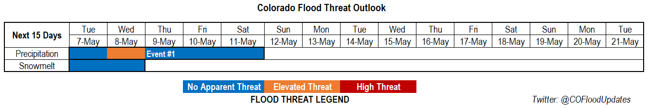
Valid Dates: 5/7 – 5/21
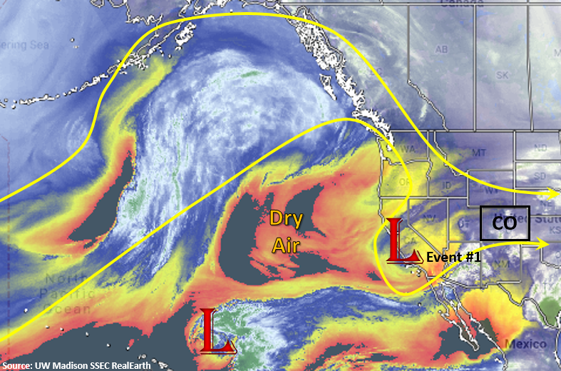
After a weekend and Monday with gorgeous weather, an active weather pattern returns for the rest of the work week. The water vapor imagery below shows the low pressure system starting to move over southern California from the Pacific. This will change our upper level flows from westerly to more southwesterly, and it will also pull in a ribbon of moisture from the southwest over the state. An upper level jet stream along with lift out in front of this trough will provide sufficient lift for scattered showers and thunderstorms this week and marks the beginning of Event #1.
The cutoff low is expected to navigate into the Four Corners region on Monday night into Tuesday. This should increase shower and thunderstorm activity on Tuesday afternoon as easterly flow at the surface will keep low level moisture in place. So expected light showers and heavy cloud cover tomorrow morning with increasing coverage of showers during the afternoon. On Wednesday, the trough digs south on its backside, which should hold the unsettled pattern in place. Models show a a cold front sliding south through the state sometime between Wednesday morning and afternoon. By Wednesday evening, ongoing showers are expected to turn to snow as cold air takes control of the area. This cold front should drop freezing levels to 6-7K feet by late Wednesday into Thursday morning. Moderate snow accumulation (5-15 inches) is forecast over the higher elevations from Tuesday into Thursday with snow possible over the foothills as well. With two days of rain (Tuesday-Wednesday), recent burn scars may have some flooding issues, which is why there is an elevated threat in the middle of Event #1. However, freezing temperatures overnight on Wednesday into Thursday should nix this threat. By Friday, another cut off low forms over the southwest US, but it should be far enough west that only the southernmost portions of the state will be affected by another afternoon of scattered thunderstorms.
As far as snowmelt, there be a couple more days of melting (mostly south, central Colorado) before temperatures drop off enough to stall the melting. While most gages are on the rise, all major rivers are still well below action stage. Peaks in streamflow tend to occur in late May into June for the larger rivers. However, there are a couple gages that are near action stage on smaller rivers that should be watched closely this week. The first is Mancos River near Mancos in Montezuma County, and the second is Surface Creek in Pitkin County. Neither are expected to produce major flooding, but smaller rivers at lower elevations had some minor flooding issues during the last rainfall event.
Event #1: Tuesday (5/7) – Friday (5/10)
Elevated/No Apparent Threat as the cutoff low moves into the four corners region and helps provide lift and moisture for widespread showers, thunderstorms and snow.
Heavy cloud cover and light rain is expected by Tuesday morning as the low pressure system moves into the Four Corner region and moist, upslope flow continues. Showers and thunderstorms are expected to increase into the afternoon on Tuesday. A couple of severe storms may be possible out east. Rain continues into Wednesday with easterly flow and moisture in place, which may cause some issues for recent burn scars. By Wednesday night, temperatures are expected to drop drastically behind a cold front, which should bring the snow level down to 6-7K feet. A bit of a break with precipitation on Wednesday night, though storms are likely again Thursday afternoon. The unsettled pattern will finally start to ease up and there will be a downtick in coverage by Friday. At that time, only scattered showers and a few isolated thunderstorms are expected over the southern border of Colorado. Flooding is not expected at this time though burn scars may have some issues Wednesday before temperatures drip below freezing.