Issue Date: Thursday, May 2nd, 2019
Issue Time: 1:50PM MDT
Valid Dates: 5/3 – 5/17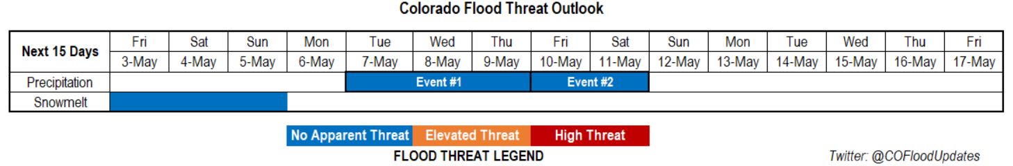
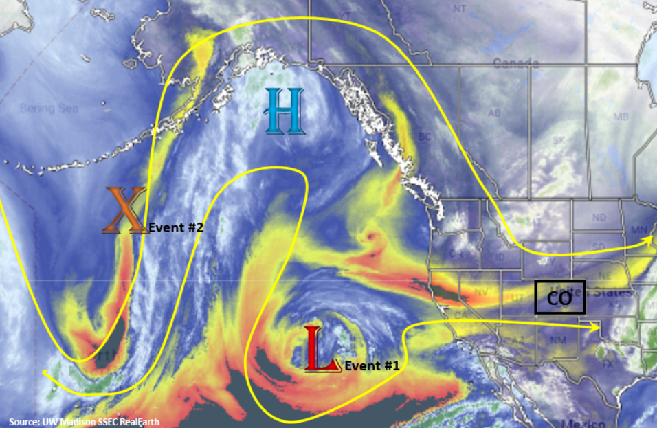
Temporary relief from the active spring pattern is expected to start tomorrow and last through Monday. The North Pacific water vapor imagery below shows the elongated trough that is currently producing westerly flow over the state. The trough finally moves fully to the east overnight, and in its place, a weak ridge begins to (briefly) build over the state. Temperatures over the weekend should run 5° to 10°F above normal, which could significantly melt some of the historical snowpack (see below). Drier air is also pulled in from the Great Basin with the weak westerly and northwesterly flow aloft, which should nix any substantial precipitation. PW does seem to increase a little on Sunday, so some high-based showers may be possible over the higher terrains during the afternoon.
Event #1 begins as the cutoff low begins to move into the Four Corners region on Monday night. There also seems to be a cold front that drops through early on Tuesday, which should drop high temperatures closer to more seasonable values. Of course, timing of the event could change, so tune back into Monday’s FTO. The cutoff low is then absorbed into the main flow and travels southwest to northeast across the state on Wednesday, which should bring another day of widespread showers and general cloudiness. After Wednesday, the main trough remains intact west of Colorado and strengthens as a vorticity max drops south on the backside of the trough late on Thursday. This should help continue the active pattern and marks the start of Event #2. While timing is still a little questionable, this second shortwave should keep showers and thunderstorms in the forecast through Saturday.
Winter Recap
It has been quite the jump from dire drought conditions at the end of the 2018 FTB season to now. Thanks to an active winter pattern, and a few big storms at the beginning of March, almost all of the state has (thankfully) recovered from the historic drought. Below are two images from the High Plains Regional Climate Center (HPRCC) who track the drought classification across the state. On the left are the drought conditions at the start of the Water Year 2019 (WY2019 starts in October) and on the right are the conditions at the end of April. Currently, only the southern portions of La Plata and Archuleta counties have Moderate Drought (D1), with only a small portion of the state remaining in the Abnormally Dry category (D0).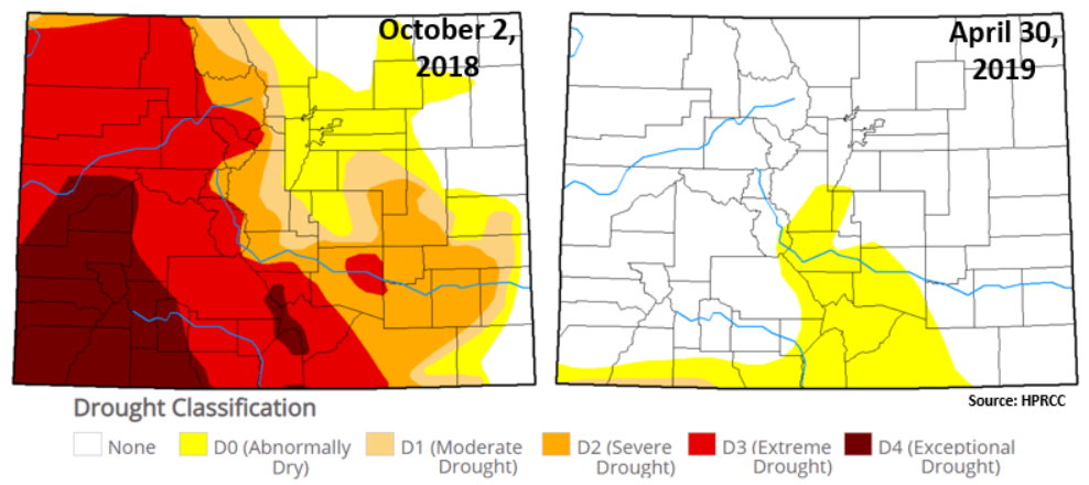
Taking a look at the percent of normal precipitation from the beginning of the WY2019 to now, it’s not surprising the majority of the state is at or above 90% of normal precipitation. While the Front Range and Southeast Mountains did not see as much precipitation (mostly in the form of snowfall) as the San Juan and Central Mountains, most of those areas still received 90% of normal precipitation. Outside of Logan County, the state has received at least 70% of normal precipitation. While the active pattern could slow down over the summer, and in turn portions of the state could fall back into a drought, the recovery of the drought (in only a single winter!) is just short of miraculous.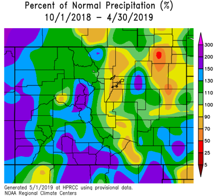
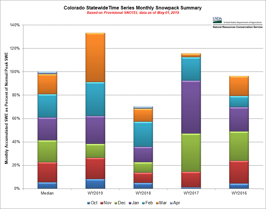
The NRCS also provided a useful map to put the historical snowpack into perspective. Below, you can see what average Snow Water Equivalent (SWE) from Oct-Mar (far left) and compare it to the last four Water Years. First, statewide, Colorado snowpack is above 130% for WY2019! This is almost double the SWE from last year (WY2018). Two storms at the beginning of March (orange) were big contributors to bringing the statewide SWE past the 100% mark for WY2019. What is also interesting about the graph is how far behind the state was on SWE before January 1st. This just goes to show how difficult it can be to produce accurate spring runoff forecasts (that are largely based on SWE) before the start of the year. In an effort not to go into too much detail, the historic drought and subsequent recovery was one for the books!
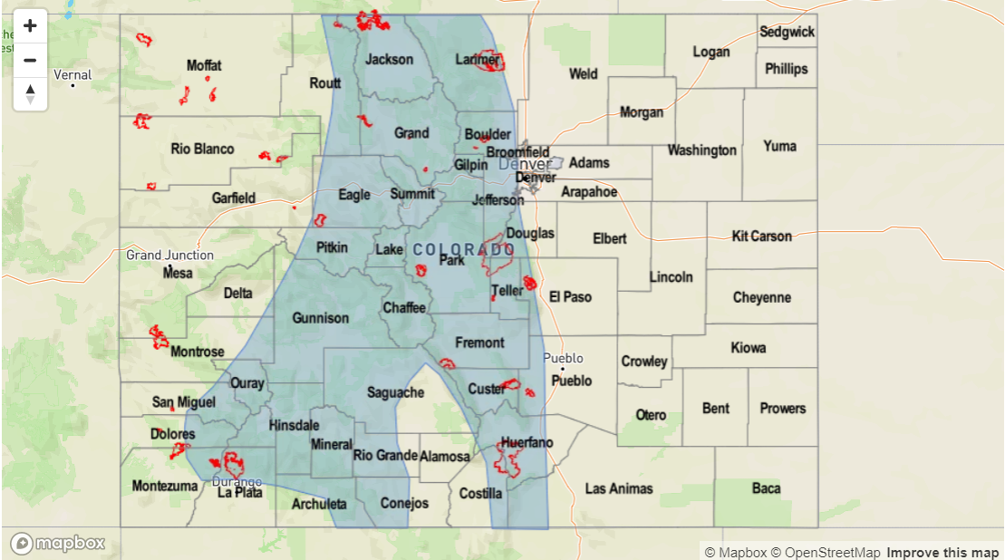
Typically when snowpack reaches 130% of normal, we start to worry about high spring runoff and riverine flooding. This is something we will watch closely this season, especially if the snowpack continues to stay intact later into the season. This would allow for some possible snow on rain events, though those are not typical for our state. An example of this occurred yesterday in Conejos County. Light rain and an already melting snowpack combined to produce some very high flows and minor flooding along the Conejos and San Antonio Rivers just east of Antonito. Other lower elevation, smaller streams in the Central and San Juan Mountain regions have been reported running at or near bankfull. Time series of SWE show all the CO river basins (minus the South Platte) having significant snowmelt occurring. With temperatures 5° to 10°F above normal this weekend, except rivers to continue to rise with the largest threat for flooding along smaller rivers and streams at lower elevations.
Event #1: Tuesday (5/7) – Thursday (5/9)
No Apparent Threat as the cutoff low moves into the four corners region and produces widespread showers and cooler temperatures.
While the event is still a bit of a ways out with details evolving, it looks like the next system to bring showers and thunderstorms to the state will occur at the beginning of next week. Plenty of moisture should be in place for widespread showers and general cloudiness starting on Tuesday. Temperatures are also forecast to drop off as a cold front moves through early Tuesday. This means some stratified rain may be possible over the plains. As mentioned above, a rain on snow event after a weekend of significant snowmelt, may produce some small stream flooding in the mountains, so we will be watching this closely. This looks to be a statewide event over the 3 days with the highest rainfall amounts likely over the higher elevations. Severe thunderstorms cannot be ruled out due to decent dynamics in the area, though the specific details are not currently accurate enough to forecast. Please tune back into Monday’s FTO for the latest. Flooding is not expected at this time.

Event #2: Friday (5/10) – Saturday (5/11)
No Apparent Threat as a vorticity max drops south and re-strengthens the trough to the west of Colorado.
Occurring just after Event #1 is Event #2. This next event occurs as the large scale trough over the west coast (responsible for the active pattern this spring) re-digs south and west of Colorado. This should allow multiple shortwaves to move through the state and possibly mix with some upper level support from the jet stream. Friday will likely have more scattered storms than Saturday, but again the details of the event are likely to evolve and change over the next week. Flooding is not expected at this time.