FTO 06-06-2019: Cool Down Forecast for this Weekend & an Increase in Thunderstorm Activity

Issue Date: Thursday, June 6th, 2019
Issue Time: 1:00PM MDT
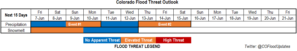
Valid Dates: 6/7 – 6/21

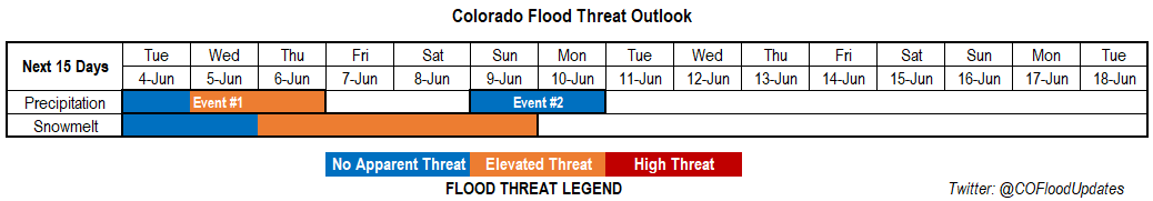
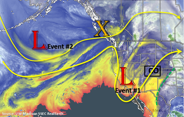
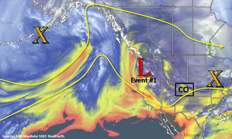
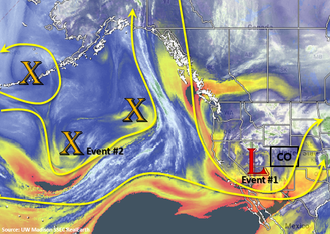
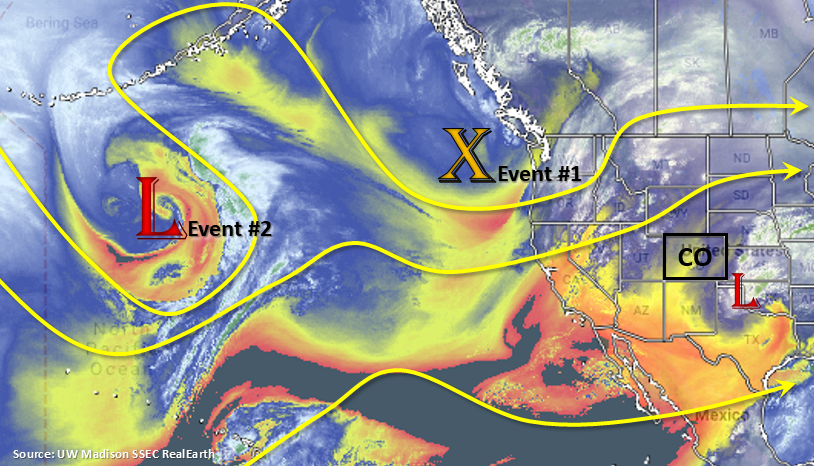
The low that passed to our south yesterday can be seen over the Texas Panhandle in the water vapor imagery below. Behind this low, a ridge begins to build over Colorado, which will bring warmer temperatures to the area over the next couple of days. Event #1 really begins as the next trough drops south on Saturday. The trough will brush the northern border of the state as it dips south, but the building high over Mexico will keep it from fully dropping through the state. It is a relatively quick moving system, so it shouldn’t stick around for longer than a couple of days. However, it is associated with the polar jet, which means it will bring some cooler temperatures to the state. Sometime between Saturday morning and afternoon, it will drop a strong cold front through the state, which will significantly drop high temperatures on Sunday and Monday. Depending on timing of the cold front, heavy rainfall, severe weather and even overnight rainfall on the plains is possible. Expect the cooler temperatures and increased low level moisture to last through Monday.

Northwesterly flow fills in behind the passage of the trough, which will likely drop weak cool fronts through the state, mid-level energy and on/off low level moisture Tuesday into Wednesday. This usually creates an active precipitation pattern with most of the action remaining over the mountains. Some activity can be expected in the adjacent plains with the steering flow, but the drop off in moisture lowers the flood threat. Event #2 begins at the end of next week as a weak trough sets up over the west coast. While a lot can change with a forecast this far out, an Elevated flood threat has been issued as PW tends to start to creep up over the eastern plains during this point in the year. Should the mid-level energy pair with higher moisture values, heavy rainfall may be possible.

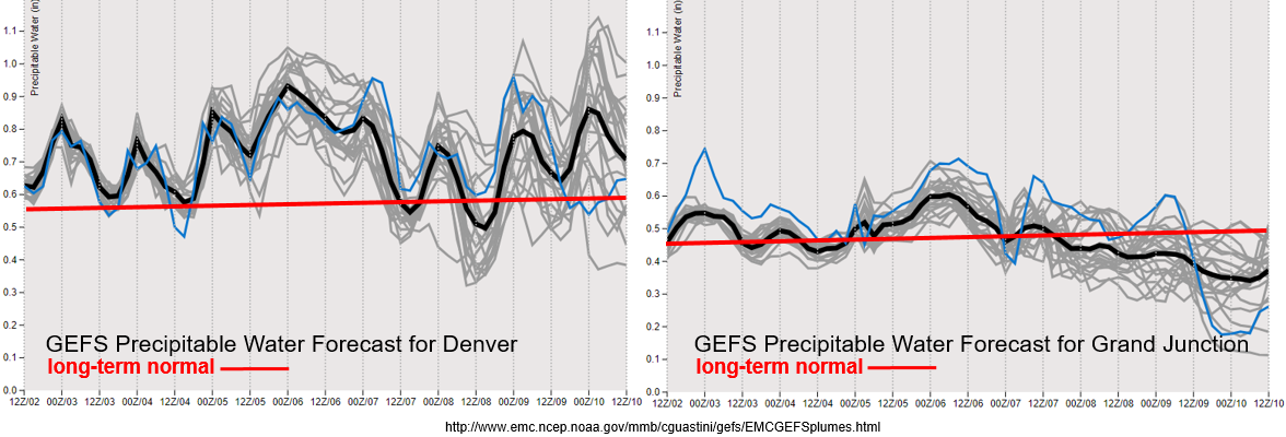
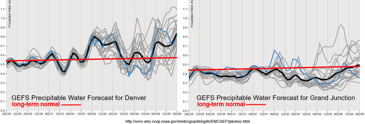
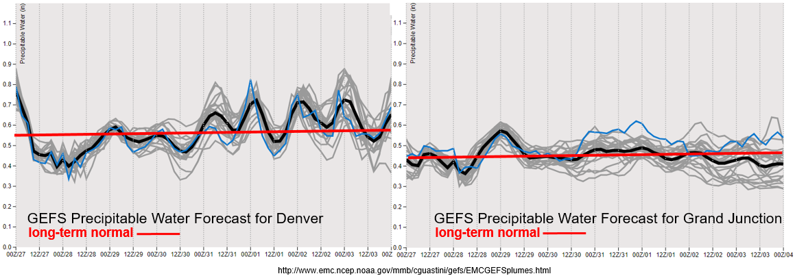
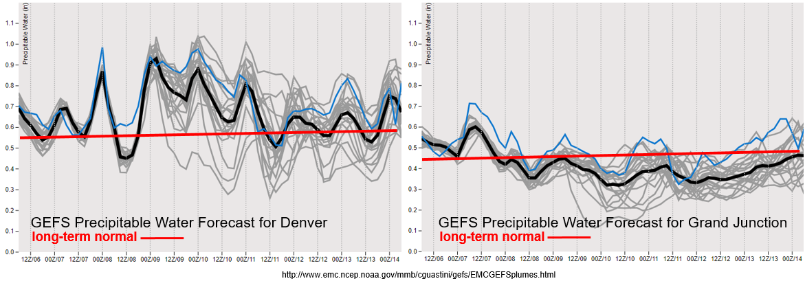
After tomorrow evening, PW for Denver drops off drastically before the next approaching system. There is a large increase in moisture and less amplified diurnal cycle from into Monday; thus, the Elevated flood threat. After Monday, PW values show large spread and decrease to more climatological values through next Thursday. To the west, PW drops off beginning tomorrow morning with the flow becoming more southwesterly and westerly. This will pull in the dry air seen in the water vapor imagery above. With the jet overhead, critical fire weather is possible beginning as early as tomorrow afternoon due the combination of increasing winds and low relative humidity. This may be upgraded to a Red Flag Warning, so please follow the daily FTB for the latest.

Snowpack:

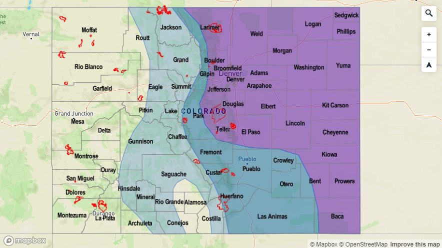
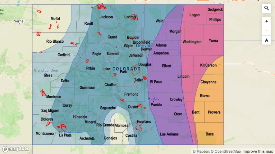
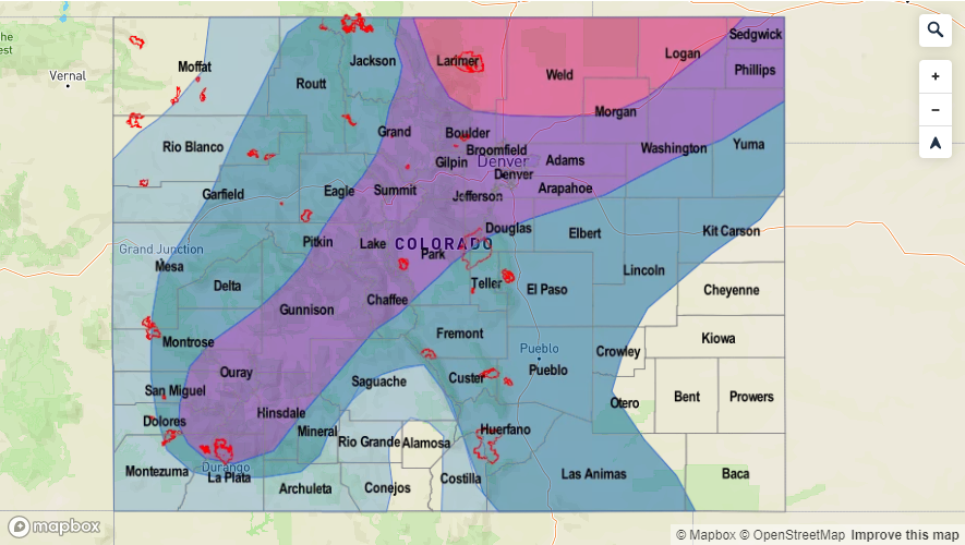
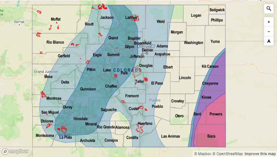
The very hot stretch of weather will come to an end with the approaching system this weekend. Thus, the Elevated threat (for small rivers and streams over western and southern Colorado) will end by Sunday evening. After the cooler temperatures are in place, expect the melting rate to slow and water levels stabilize. The Flood Warning for the San Antonio and Conejos Rivers has been extended through Monday morning by the NWS. Expect minor flooding throughout the weekend with the high flows. Elsewhere, several advisories have been issued (see the SPM from today) as many mountain streams continue to run at or slight above bankfull. There have not been any reports of flooding yet, but use caution near the cold and rushing waters. Hot temperatures return to the forecast by the end of next week, so expect a ramp up in runoff once again. Please tune into the FTO next week for evolving details.

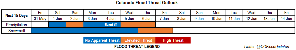
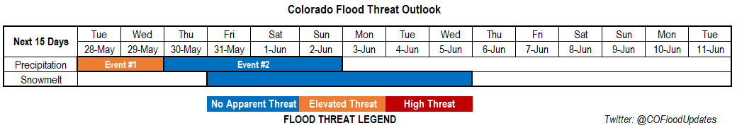
Event #1: Friday (6/7) – Monday (6/10)

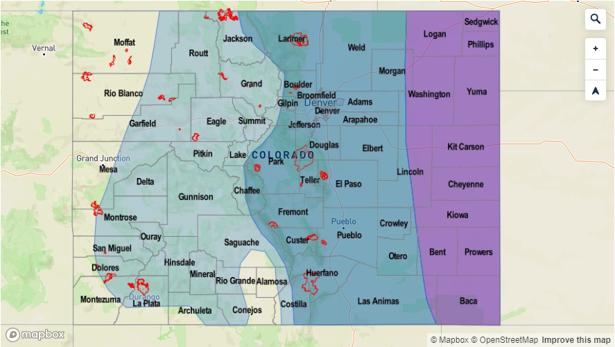
No Apparent Threat/Elevated Threat as a trough brushes the northern border of the state.

The polar jet stream dips south for the next event and will brush the northern border of Colorado. Due to the fast motion of the system not expecting widespread flooding. However, a cold front on Saturday will help return low level moisture and cause heavy rainfall for the eastern plains of Colorado if it passes through during maximum instability. Therefore, expect an increase in thunderstorm activity by Saturday evening with much cooler temperatures on Sunday and Monday. The Elevated threat remains on Monday as PW remains high and storms are possible over the mountains. This could be problematic if they track over a recent burn area. The threat decreases after Event #1 as PW values drop off over eastern Colorado, although storms are still possible over the higher terrains each afternoon

Legend


Event #2: Thursday (6/13) – Saturday (6/15)

Elevated Threat as a weak troughing pattern looks to set up to the west of Colorado again and returns southwesterly flow.

Event #2 begins at the end of next week as it looks like another weak trough sets up to our west and turns flow to southwesterly over the state. Again, not a lot of confidence in the details as a lot can change, but Elevated flood threat has been issued as PW tends to start to creep up over the eastern plains during this point in the year. This system could bring heavy rainfall and severe weather to the eastern plains.

Legend

FTO 06-03-2019: The Upper Level Low Travels South of Colorado Returning the Flood Threat by Mid-Week

Issue Date: Monday, June 3rd, 2019
Issue Time: 2:15PM MDT
Valid Dates: 6/4 – 6/18

The water vapor imagery below continues to show a bit of a split pattern with the polar jet stream well to our north. Currently, the upper level cutoff low (Event #1 from the last FTO) is over southern California. This nearly stationary feature has been brining on and off moisture into the area and allowing some more seasonable and warm temperatures to build across state. By Wednesday, the low begins to move east into Arizona and then New Mexico. The plume of moisture east of the green line below will begin to be pulled back west and increase the chances for rainfall (statewide) by Wednesday. After the low passes through the area, there will be a lull in precipitation with only scattered afternoon showers expected over the higher terrains. By Sunday, Event #2 begins as the low near the Gulf of Alaska brushes the northern border of Colorado as it navigates to the east. Still not a lot of confidence in the exact placement of the upper trough, but an increase the amount of low level moisture is forecast behind the passage of a cold front on Saturday night. With swift storm movement and abundant low-level moisture missing, there is No Apparent Threat at this time.

Above average PW values are forecast by the GEFS for Denver through next week (left). As the low approaches from the west, PW peaks on Wednesday. While the amount of instability may be limited during the passage of the upper low (less of a severe threat), higher PW and slow storm movement may cause some flooding issues, especially over recent burn scars. There is then a sharp decrease in moisture before the next system arrives at the beginning of next week. This should drop the chances for afternoon rainfall into next weekend and limit the majority of the storm activity to the mountains. To the west, PW values are about average until drier air moves in with more westerly flow after Event #1. There is also a slight increase on Wednesday as the low moves into the area, which may pose a threat for the 416 burn area. Again, this is mostly due to slow storm motion, which will allow more rain to accumulate than usual. Confidence in details this far out is on the lower end, so please tune back into the FTB on Wednesday morning for updated details.

Well you’re right if you were thinking May felt awfully cold and rainy. The majority of the state, excluding portions of the Southeast Plains, had above average precipitation. A good portion of western Colorado had much above average precipitation putting it in the 90th percentile. While southwest Colorado only received 0.75 to 1.5 inches above climatology, that value equates to over 200% of normal. Portions of the Southeast Plains were 0.75 to 1 inch below average, which is about 50% of normal. This continuation of above average precipitation for the Water Year actually eliminated the drought, which is the first time that has ever happened since the Drought Monitor was created in 2000. As far as temperatures, the far northeast corner of the state and pockets of the Southwest Slope were the coldest on record. Statewide, Colorado was in the bottom 10% of May temperature rankings. The colder temperatures extended the life of the snowpack at higher elevations, but warm temperatures last week into this week should start to melt a good portion of the snowpack.

Snowpack:

The long stretch of warm weather continues, and a large chunk of the snowpack has melted over the last week. This has led to bankfull conditions and minor flooding over smaller rivers within the southern San Juans that drain into the San Luis Valley region. Expect minor flooding to continue throughout this week though there may be a brief break in widespread melting on Wednesday and Thursday as cooler temperatures accompany the upper low. Elsewhere, large rivers continue to rise, but should still remain below Action stage through this week. With warm temperatures remaining in the forecast, smaller rivers and streams will likely fill to bankfull and minor flooding is possible by the end of this week. The Mancos River near Mancos is in Action stage and is expected to remain here through the rest of this week with minor flooding of low-lying areas possible. Please tune into the daily FTB for the latest details on flooding.

Event #1: Tuesday (6/4) – Thursday (6/6)

No Apparent Threat/Elevated Threat as a cutoff low moves east and passes Colorado to the south.

The upper level low finally begins to move east this week. PW peaks as it passes through Arizona and New Mexico on Wednesday. This should bring widespread showers to the state and cooler temperatures. Without a ton of instability building (with the exception of the far northeast corner of the state), rainfall will be more gradual. However, slow storm motion will create an Elevated flood threat with burn scars particularly susceptible to flooding. Small creeks and rivers will also start to approach bankfull with minor flooding possible by the end of this week. Major riverine flooding is not forecast though river levels will continue to rise.

Legend

Event #2: Sunday (6/9) – Monday (6/10)

No Apparent Threat as a quick moving upper level system brushes the northern Colorado border and brings cooler temperatures to start the week.  

The polar jet stream dips south for the next event and will brush the northern border of Colorado. Due to the fast motion of the system and lack of low level moisture, widespread flooding is not forecast. A cold front on Saturday night will help drop temperatures and return low level moisture over eastern Colorado on Sunday. Therefore, there is an uptick in thunderstorm activity forecast over the mountains on Sunday afternoon. By Monday, residual moisture will likely spark another round of isolated afternoon storms over the mountains, but at this time, there is No Apparent flood threat.

Legend

FTO 05-30-2019: Colorado Finally Begins to Heat Up, which will Ramp Up the Runoff

Issue Date: Thursday, May 30th, 2019
Issue Time: 12:30PM MDT
Valid Dates: 5/31 – 6/14

Only one event for this FTO. The low pressure system shown in the water vapor imagery below dips south and becomes cut off from the main flow through the middle of next week. This will allow a ridge to begin to build back to the northwest and increase high temperatures statewide. Lower elevations will reach the 80Fs by Sunday and stick around into next week. Daily showers are expected over the higher terrains during Event #1 with on and off periods of severe weather possible over the eastern plains. For the most part, widespread flooding is not anticipated. However, increased PW values over the eastern plains on Sunday and Monday may allow for some heavy rainfall and severe thunderstorms. Small movements of the low will change 500mb flow between westerly and southwesterly during this period, which will increase and decrease the coverage of thunderstorms each afternoon. Finally, the low starts to slowly move through the state from the south during the middle of next week, which should bring an increase in rainfall and coverage.

The GEFS Precipitable Water forecasts for Denver (left) and Grand Junction (right) below show the long-term normal slowly increasing once again. Climatologically, there are quick increases and decreases in daily PW during this time of year, which is exactly what the plumes indicate below. By Sunday, PW values increase across eastern Colorado with a slight eastward shift of the ridge. This uptick in moisture will likely allow storms to move off the mountains into the adjacent plains during the afternoon starting on Saturday (with the main threat Sunday) and increase precipitation coverage over the mountains. With slower storm motion and an uptick in moisture by Sunday, storms that track near burn scars should be monitored closely. Daily details for rain rates can be found in the FTB. Not quite the same return in moisture for western Colorado, but westerly flow transitioning to SW flow on Sunday will likely increase moisture over the southwest corner of the state, which in turn, will increase the coverage of afternoon, diurnally driven storms over the San Juan Mountains. Quite a bit of spread in both PW plumes below by next week due to the small differences in the placement of the low by each ensemble member. How it drifts around southern California and the desert southwest during this period is not well known.

Snowpack:

A long stretch of warm weather is finally here, which means there will be a large chunk of the snow melting over the next week. Both major and minor rivers’ current levels are low enough that during the first part of this FTO, there is no apparent threat. However, after a week of warm weather, it is likely that high elevation small streams and creeks will become bankfull by Wednesday or Thursday of next week. The areas most susceptible to bankfull conditions will be the higher terrains of western Colorado and any drainages within the San Luis Valley. Should temperatures continue to remain high (as anticipated), flooding of these smaller rivers and creek could occur as early as next weekend. At this time, no major rivers are forecast to reach Action or Minor flooding stages during this FTO, but this will be monitored closely over the next week. Please tune back into the FTO on Monday to see if there is an update or upgrade with the melting snowpack.

Event #1: Saturday (6/1) – Thursday (6/6)

No Apparent Threat/Elevated Threat as a cut of low and slight movements in the ridge over the state cause increases and decreases in moisture and instability through next week.

As mentioned above, slight movements of the cut off low will cause increases and decreases in moisture and instability over the next week. While the ridge or low aren’t strong, the pattern indicates somewhat of a dirty ridge over the state during this period. This will translate into some days having more mid-level energy to help spark wider coverage of storms and help produce severe weather over the eastern plains. On Sunday, PW values increase drastically over the Southeast Plains. This may cause some flooding issues with the potential severe thunderstorms. Threats with these storms would include large hail, strong winds, local heavy rainfall and perhaps a tornado or two. The severe thunderstorm threat shifts to the Northeast Plains on Monday, but the threat for heavy rainfall is slightly lower, so No Apparent Threat has been issued.

Daily rounds of storms are anticipated over the mountains each afternoon through next week. By mid-week, the low finally starts to move over the state, which should cause an uptick in moisture and storm coverage by Wednesday and Thursday. With slower steering winds still likely overhead, an Elevated Flood Threat has been issued for this period.

Slower steering winds during this next FTO paired with days of increased low level moisture will be watched closely in the daily FTB. This may cause issues for recent burn areas if a storm tracks over them. Particularly the Spring Creek burn area, because it will take a lower rainfall threshold to cause mud flows, debris slides and flash flooding this season. Multiple rounds of mountain showers and increased melting may also help saturate soils by the time the low arrives next week. Again, please follow the FTB each morning for the latest details.

Legend

FTO 05-27-2019: Cool Start to the Week with Afternoon Storms Possible into Next Weekend

Issue Date: Monday, May 27th, 2019
Issue Time: 11:00AM MDT
Valid Dates: 5/28 – 6/11

Looking at the water vapor imagery below, today looks very similar to the last FTO. Currently, there is a low to Colorado’s southwest that will move to the northeast throughout the day into tomorrow. The general trough pattern continues throughout the week, although the amplification of the trough decreases by the end of the week. Nonetheless, afternoon storms should stay in the forecast through this weekend. Tonight, a cold front begins to drop through the state as the low passes to the north, which should drop high temperatures 10-15°F for tomorrow. This will also drop the snow line between 8-9K feet allowing the mountains to get decent accumulation tonight and Tuesday evening. Northerly flow keeps cold air in place for Wednesday as the low linger to the northeast over the panhandle of Nebraska. This could bring near freezing temperatures to the lower elevations Tuesday night into Wednesday morning. Storms the next couple of days are forecast to be more stratiform in nature with some embedded convection. A few weak thunderstorms (rather than severe thunderstorms) are also possible. As far as storm motion, 500mb flow turns from more southerly to northerly Tuesday as the low passes. By Wednesday, 500mb flow will remain from the north to the west and become more westerly to the east. Small disturbances are expected to move through the flow, which should help initiate afternoon convection over the mountains with the diurnal cycle during the afternoon.

The GEFS Precipitable Water forecasts for Denver (left) and Grand Junction (right) below show dry air filling in very quickly after the current system passes. After the cold front passes through tonight, low level moisture begins to return both east and west of the Divide. Values remain near climatology for the first part of the week, but by Thursday, values begin to increase to the east. This is also when temperatures are expected to rebound as the lingering low pressure system finally moves east, so expect CAPE to increase over eastern Colorado as well. This may bring some stronger storms to the forecast by the end of the week over the adjacent plains and mountains. PW values remain under 1 inch, so widespread flooding is not anticipated. However, with slow moving storms the next couple of days, burn scars will need to be monitored closely. An Elevated flood threat has been issued for this reason.

Snowpack:

The next system looks to be cold enough that melting should hold off until the end of this week. In fact, accumulations of 6 to 10 inches are possible over the next couple of days above 9K feet. Typically, temperatures need to remain above 45°F in the high country for 5 consecutive days for major runoff to begin. The warm up and de-amplification of the trough into next week should start the melt out process again, but there is No Apparent threat yet. Mostly, expect large rivers to start seeing an increase in base flow with small rivers and creeks approaching bankfull by the end of this period. This will continued to be monitored throughout the week with a much more detailed/confident forecast coming early next week.

Event #1: Tuesday (5/28) – Wednesday (5/29)

Elevated Threat for recent burns areas as stratiform rain, embedded convection and snow (for the highest elevations) return as the next system pushes north of the state.

A major cool off is forecast overnight on Monday as a low moves to the northeast and just north of the state. This next system should cause an increase in widespread shower activity with snow possible the next couple of nights over the mountains (snow line dropping between 8-9K feet). Rain should be more stratiform in nature with some embedded convection, and a couple weak thunderstorms cannot be ruled out. Embedded convection may pose a threat for recent burn areas on Tuesday and Wednesday afternoon if a storm tracks over a recent burn area. Thus, the Elevated flood threat. Elsewhere, gradual rain and snow should limit the flood threat. Please tune back into the FTB tomorrow and Wednesday for the latest.

Legend

Event #2: Thursday (5/30) – Sunday (6/2)

No Apparent Threat as a broad trough keeps afternoon storms in the forecast for the higher elevations and returns the severe thunderstorm threat to the eastern plains next weekend.

Although the trough becomes broader throughout the week, afternoon storms over the high terrains are possible each afternoon. Activity may spill out over the adjacent plains with the westerly motion. For the most part, dry low levels should keep the threat for heavy rainfall minimal. There is a slight increase in southwest flow by the end of this week. With the warm up, more shortwave activity passing through the state and some better moisture over the eastern plains, severe weather may be possible again. Threats could include large hail, damaging wind, local heavy rainfall and possibly a tornado or two if the parameters align properly. So for the details, still a bit too far out to nail them down, but please tune into Thursday’s FTO and the daily FTBs for more specific information.

Legend