Issue Date: Monday, June 3rd, 2019
Issue Time: 2:15PM MDT
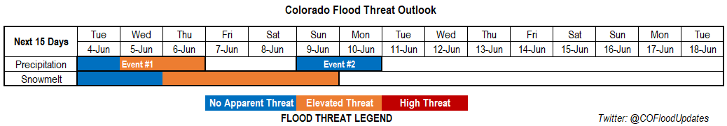
Valid Dates: 6/4 – 6/18
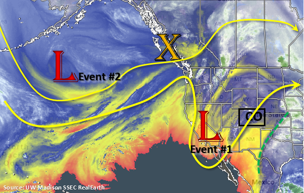
The water vapor imagery below continues to show a bit of a split pattern with the polar jet stream well to our north. Currently, the upper level cutoff low (Event #1 from the last FTO) is over southern California. This nearly stationary feature has been brining on and off moisture into the area and allowing some more seasonable and warm temperatures to build across state. By Wednesday, the low begins to move east into Arizona and then New Mexico. The plume of moisture east of the green line below will begin to be pulled back west and increase the chances for rainfall (statewide) by Wednesday. After the low passes through the area, there will be a lull in precipitation with only scattered afternoon showers expected over the higher terrains. By Sunday, Event #2 begins as the low near the Gulf of Alaska brushes the northern border of Colorado as it navigates to the east. Still not a lot of confidence in the exact placement of the upper trough, but an increase the amount of low level moisture is forecast behind the passage of a cold front on Saturday night. With swift storm movement and abundant low-level moisture missing, there is No Apparent Threat at this time.
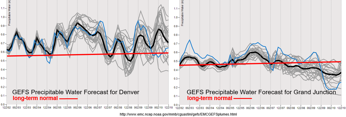
Above average PW values are forecast by the GEFS for Denver through next week (left). As the low approaches from the west, PW peaks on Wednesday. While the amount of instability may be limited during the passage of the upper low (less of a severe threat), higher PW and slow storm movement may cause some flooding issues, especially over recent burn scars. There is then a sharp decrease in moisture before the next system arrives at the beginning of next week. This should drop the chances for afternoon rainfall into next weekend and limit the majority of the storm activity to the mountains. To the west, PW values are about average until drier air moves in with more westerly flow after Event #1. There is also a slight increase on Wednesday as the low moves into the area, which may pose a threat for the 416 burn area. Again, this is mostly due to slow storm motion, which will allow more rain to accumulate than usual. Confidence in details this far out is on the lower end, so please tune back into the FTB on Wednesday morning for updated details.
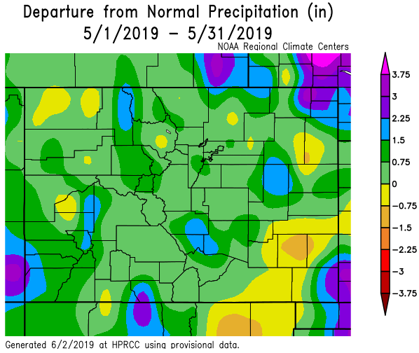
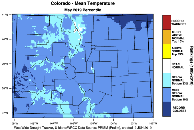
Well you’re right if you were thinking May felt awfully cold and rainy. The majority of the state, excluding portions of the Southeast Plains, had above average precipitation. A good portion of western Colorado had much above average precipitation putting it in the 90th percentile. While southwest Colorado only received 0.75 to 1.5 inches above climatology, that value equates to over 200% of normal. Portions of the Southeast Plains were 0.75 to 1 inch below average, which is about 50% of normal. This continuation of above average precipitation for the Water Year actually eliminated the drought, which is the first time that has ever happened since the Drought Monitor was created in 2000. As far as temperatures, the far northeast corner of the state and pockets of the Southwest Slope were the coldest on record. Statewide, Colorado was in the bottom 10% of May temperature rankings. The colder temperatures extended the life of the snowpack at higher elevations, but warm temperatures last week into this week should start to melt a good portion of the snowpack.
Snowpack:
The long stretch of warm weather continues, and a large chunk of the snowpack has melted over the last week. This has led to bankfull conditions and minor flooding over smaller rivers within the southern San Juans that drain into the San Luis Valley region. Expect minor flooding to continue throughout this week though there may be a brief break in widespread melting on Wednesday and Thursday as cooler temperatures accompany the upper low. Elsewhere, large rivers continue to rise, but should still remain below Action stage through this week. With warm temperatures remaining in the forecast, smaller rivers and streams will likely fill to bankfull and minor flooding is possible by the end of this week. The Mancos River near Mancos is in Action stage and is expected to remain here through the rest of this week with minor flooding of low-lying areas possible. Please tune into the daily FTB for the latest details on flooding.
Event #1: Tuesday (6/4) – Thursday (6/6)
No Apparent Threat/Elevated Threat as a cutoff low moves east and passes Colorado to the south.
The upper level low finally begins to move east this week. PW peaks as it passes through Arizona and New Mexico on Wednesday. This should bring widespread showers to the state and cooler temperatures. Without a ton of instability building (with the exception of the far northeast corner of the state), rainfall will be more gradual. However, slow storm motion will create an Elevated flood threat with burn scars particularly susceptible to flooding. Small creeks and rivers will also start to approach bankfull with minor flooding possible by the end of this week. Major riverine flooding is not forecast though river levels will continue to rise.

Event #2: Sunday (6/9) – Monday (6/10)
No Apparent Threat as a quick moving upper level system brushes the northern Colorado border and brings cooler temperatures to start the week.
The polar jet stream dips south for the next event and will brush the northern border of Colorado. Due to the fast motion of the system and lack of low level moisture, widespread flooding is not forecast. A cold front on Saturday night will help drop temperatures and return low level moisture over eastern Colorado on Sunday. Therefore, there is an uptick in thunderstorm activity forecast over the mountains on Sunday afternoon. By Monday, residual moisture will likely spark another round of isolated afternoon storms over the mountains, but at this time, there is No Apparent flood threat.