Issue Date: Thursday, May 30th, 2019
Issue Time: 12:30PM MDT
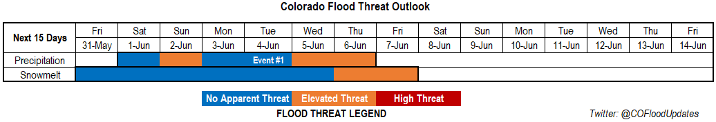
Valid Dates: 5/31 – 6/14
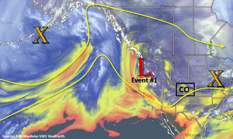
Only one event for this FTO. The low pressure system shown in the water vapor imagery below dips south and becomes cut off from the main flow through the middle of next week. This will allow a ridge to begin to build back to the northwest and increase high temperatures statewide. Lower elevations will reach the 80Fs by Sunday and stick around into next week. Daily showers are expected over the higher terrains during Event #1 with on and off periods of severe weather possible over the eastern plains. For the most part, widespread flooding is not anticipated. However, increased PW values over the eastern plains on Sunday and Monday may allow for some heavy rainfall and severe thunderstorms. Small movements of the low will change 500mb flow between westerly and southwesterly during this period, which will increase and decrease the coverage of thunderstorms each afternoon. Finally, the low starts to slowly move through the state from the south during the middle of next week, which should bring an increase in rainfall and coverage.
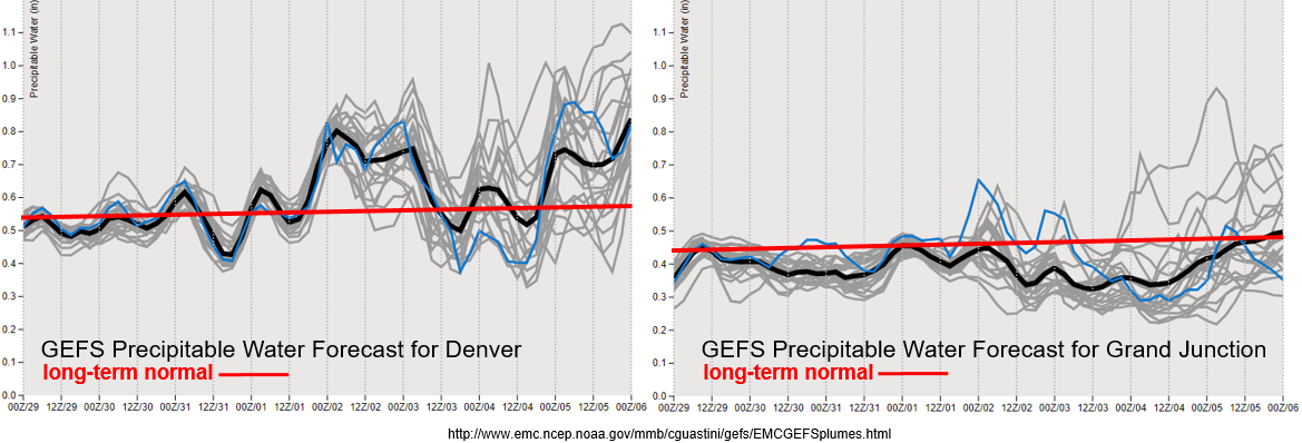
The GEFS Precipitable Water forecasts for Denver (left) and Grand Junction (right) below show the long-term normal slowly increasing once again. Climatologically, there are quick increases and decreases in daily PW during this time of year, which is exactly what the plumes indicate below. By Sunday, PW values increase across eastern Colorado with a slight eastward shift of the ridge. This uptick in moisture will likely allow storms to move off the mountains into the adjacent plains during the afternoon starting on Saturday (with the main threat Sunday) and increase precipitation coverage over the mountains. With slower storm motion and an uptick in moisture by Sunday, storms that track near burn scars should be monitored closely. Daily details for rain rates can be found in the FTB. Not quite the same return in moisture for western Colorado, but westerly flow transitioning to SW flow on Sunday will likely increase moisture over the southwest corner of the state, which in turn, will increase the coverage of afternoon, diurnally driven storms over the San Juan Mountains. Quite a bit of spread in both PW plumes below by next week due to the small differences in the placement of the low by each ensemble member. How it drifts around southern California and the desert southwest during this period is not well known.
Snowpack:
A long stretch of warm weather is finally here, which means there will be a large chunk of the snow melting over the next week. Both major and minor rivers’ current levels are low enough that during the first part of this FTO, there is no apparent threat. However, after a week of warm weather, it is likely that high elevation small streams and creeks will become bankfull by Wednesday or Thursday of next week. The areas most susceptible to bankfull conditions will be the higher terrains of western Colorado and any drainages within the San Luis Valley. Should temperatures continue to remain high (as anticipated), flooding of these smaller rivers and creek could occur as early as next weekend. At this time, no major rivers are forecast to reach Action or Minor flooding stages during this FTO, but this will be monitored closely over the next week. Please tune back into the FTO on Monday to see if there is an update or upgrade with the melting snowpack.
Event #1: Saturday (6/1) – Thursday (6/6)
No Apparent Threat/Elevated Threat as a cut of low and slight movements in the ridge over the state cause increases and decreases in moisture and instability through next week.
As mentioned above, slight movements of the cut off low will cause increases and decreases in moisture and instability over the next week. While the ridge or low aren’t strong, the pattern indicates somewhat of a dirty ridge over the state during this period. This will translate into some days having more mid-level energy to help spark wider coverage of storms and help produce severe weather over the eastern plains. On Sunday, PW values increase drastically over the Southeast Plains. This may cause some flooding issues with the potential severe thunderstorms. Threats with these storms would include large hail, strong winds, local heavy rainfall and perhaps a tornado or two. The severe thunderstorm threat shifts to the Northeast Plains on Monday, but the threat for heavy rainfall is slightly lower, so No Apparent Threat has been issued.
Daily rounds of storms are anticipated over the mountains each afternoon through next week. By mid-week, the low finally starts to move over the state, which should cause an uptick in moisture and storm coverage by Wednesday and Thursday. With slower steering winds still likely overhead, an Elevated Flood Threat has been issued for this period.
Slower steering winds during this next FTO paired with days of increased low level moisture will be watched closely in the daily FTB. This may cause issues for recent burn areas if a storm tracks over them. Particularly the Spring Creek burn area, because it will take a lower rainfall threshold to cause mud flows, debris slides and flash flooding this season. Multiple rounds of mountain showers and increased melting may also help saturate soils by the time the low arrives next week. Again, please follow the FTB each morning for the latest details.