Issue Date: Monday, May 27th, 2019
Issue Time: 11:00AM MDT
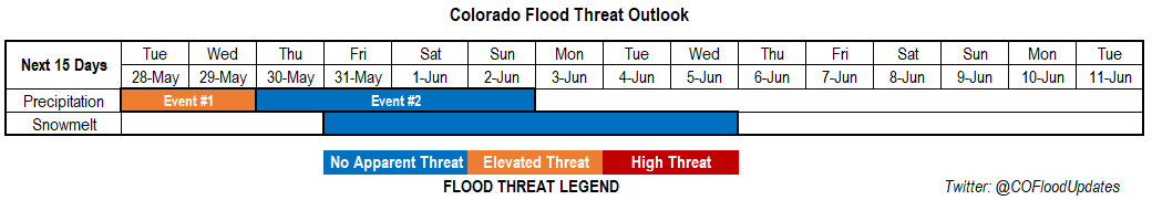
Valid Dates: 5/28 – 6/11
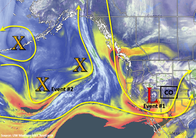
Looking at the water vapor imagery below, today looks very similar to the last FTO. Currently, there is a low to Colorado’s southwest that will move to the northeast throughout the day into tomorrow. The general trough pattern continues throughout the week, although the amplification of the trough decreases by the end of the week. Nonetheless, afternoon storms should stay in the forecast through this weekend. Tonight, a cold front begins to drop through the state as the low passes to the north, which should drop high temperatures 10-15°F for tomorrow. This will also drop the snow line between 8-9K feet allowing the mountains to get decent accumulation tonight and Tuesday evening. Northerly flow keeps cold air in place for Wednesday as the low linger to the northeast over the panhandle of Nebraska. This could bring near freezing temperatures to the lower elevations Tuesday night into Wednesday morning. Storms the next couple of days are forecast to be more stratiform in nature with some embedded convection. A few weak thunderstorms (rather than severe thunderstorms) are also possible. As far as storm motion, 500mb flow turns from more southerly to northerly Tuesday as the low passes. By Wednesday, 500mb flow will remain from the north to the west and become more westerly to the east. Small disturbances are expected to move through the flow, which should help initiate afternoon convection over the mountains with the diurnal cycle during the afternoon.
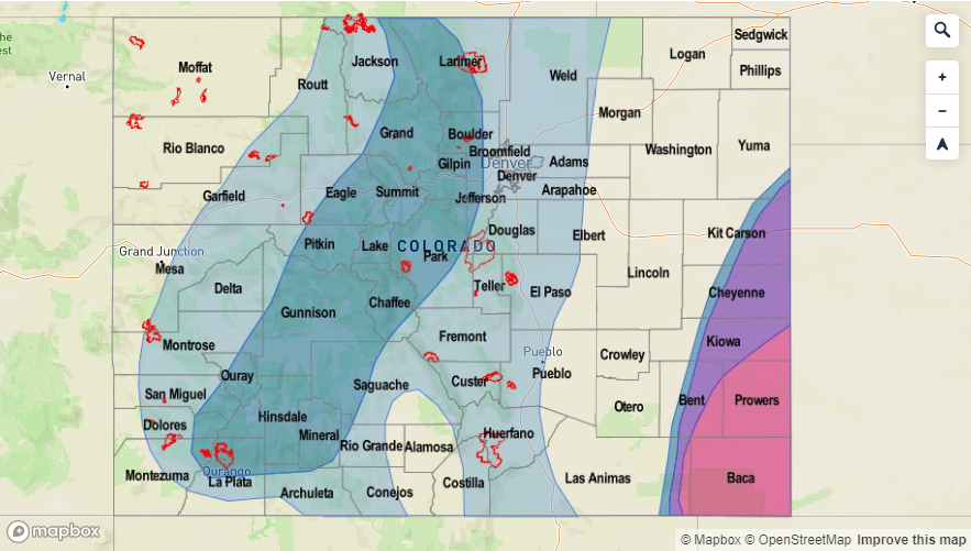
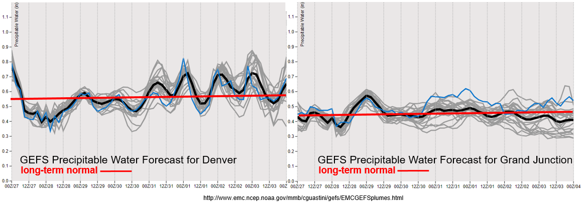
The GEFS Precipitable Water forecasts for Denver (left) and Grand Junction (right) below show dry air filling in very quickly after the current system passes. After the cold front passes through tonight, low level moisture begins to return both east and west of the Divide. Values remain near climatology for the first part of the week, but by Thursday, values begin to increase to the east. This is also when temperatures are expected to rebound as the lingering low pressure system finally moves east, so expect CAPE to increase over eastern Colorado as well. This may bring some stronger storms to the forecast by the end of the week over the adjacent plains and mountains. PW values remain under 1 inch, so widespread flooding is not anticipated. However, with slow moving storms the next couple of days, burn scars will need to be monitored closely. An Elevated flood threat has been issued for this reason.
Snowpack:
The next system looks to be cold enough that melting should hold off until the end of this week. In fact, accumulations of 6 to 10 inches are possible over the next couple of days above 9K feet. Typically, temperatures need to remain above 45°F in the high country for 5 consecutive days for major runoff to begin. The warm up and de-amplification of the trough into next week should start the melt out process again, but there is No Apparent threat yet. Mostly, expect large rivers to start seeing an increase in base flow with small rivers and creeks approaching bankfull by the end of this period. This will continued to be monitored throughout the week with a much more detailed/confident forecast coming early next week.
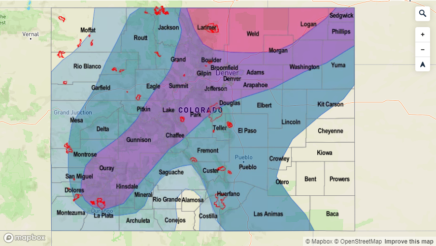
Event #1: Tuesday (5/28) – Wednesday (5/29)
Elevated Threat for recent burns areas as stratiform rain, embedded convection and snow (for the highest elevations) return as the next system pushes north of the state.
A major cool off is forecast overnight on Monday as a low moves to the northeast and just north of the state. This next system should cause an increase in widespread shower activity with snow possible the next couple of nights over the mountains (snow line dropping between 8-9K feet). Rain should be more stratiform in nature with some embedded convection, and a couple weak thunderstorms cannot be ruled out. Embedded convection may pose a threat for recent burn areas on Tuesday and Wednesday afternoon if a storm tracks over a recent burn area. Thus, the Elevated flood threat. Elsewhere, gradual rain and snow should limit the flood threat. Please tune back into the FTB tomorrow and Wednesday for the latest.

Event #2: Thursday (5/30) – Sunday (6/2)
No Apparent Threat as a broad trough keeps afternoon storms in the forecast for the higher elevations and returns the severe thunderstorm threat to the eastern plains next weekend.
Although the trough becomes broader throughout the week, afternoon storms over the high terrains are possible each afternoon. Activity may spill out over the adjacent plains with the westerly motion. For the most part, dry low levels should keep the threat for heavy rainfall minimal. There is a slight increase in southwest flow by the end of this week. With the warm up, more shortwave activity passing through the state and some better moisture over the eastern plains, severe weather may be possible again. Threats could include large hail, damaging wind, local heavy rainfall and possibly a tornado or two if the parameters align properly. So for the details, still a bit too far out to nail them down, but please tune into Thursday’s FTO and the daily FTBs for more specific information.