FTO 06-20-2019: Rain and Cool Temperatures Return to the Forecast this Weekend

Issue Date: Thursday, June 20th, 2019
Issue Time: 2:30PM MDT
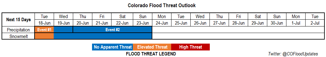
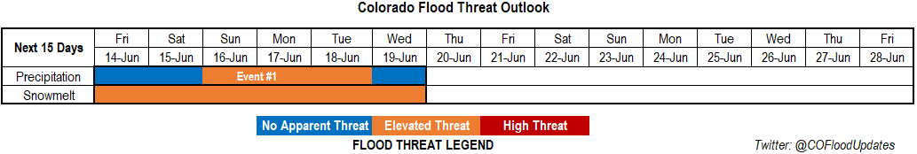
Valid Dates: 6/21 – 7/5

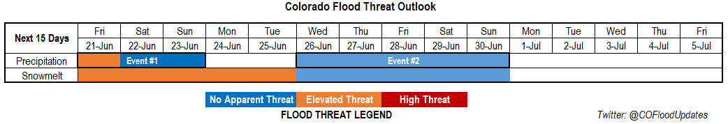
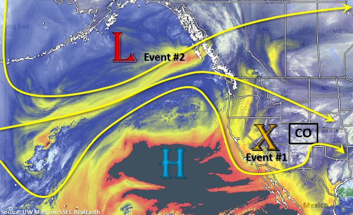
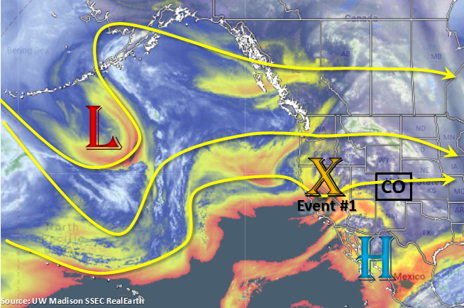
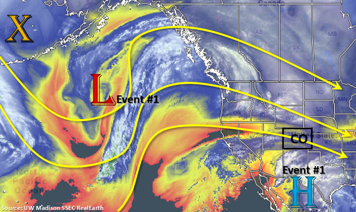
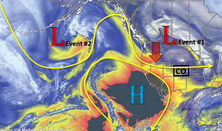
An active weather pattern with some very cool temperatures is setting up for this weekend. Currently, a strong low pressure system is sitting to our north. This low will sag south into Nevada throughout today, which will start Event #1. Southwesterly winds with the upper low will continue through tomorrow, and the upper trough to our west will push a cold front through the state during the afternoon hours. With a surface low over eastern Colorado, high moisture will allow for some heavy rainfall and severe weather along the front. Northern Colorado will also sit in the right entrance region of the jet, which should promote some overnight rainfall in the mountains. Saturday morning will begin with cool temperatures, heavy cloud cover and isolated rainfall. With southwesterly flow and the trough beginning to move through the state, unsettled weather will be forecast again. If cloud cover can burn off to create some instability over the eastern plains, another round of severe weather may also be possible. Temperatures drop drastically by Saturday night into Sunday, so some snowfall may be possible over 10,000 feet this weekend. SNOTEL will be monitored closely to identify the freezing line for the FTB. By late Sunday, the trough should be fully east of the state. This will allow for the return of northwest flow, which will promote drying and warmer temperatures to start the work week.

While details this far out will likely change, Event #2 begins mid to the end of next week as the next trough moves over the Pacific Northwest. For this event, the polar jet looks to stay further north though some mid-level energy will likely make its way into the state as the system moves eastward. This will help increase coverage of storms during the afternoon hours. The placement of the ridge to our east and the trough to the west will determine how much low level moisture will be present to fuel the rainfall. Currently, the highest PW values look to stay east of our border, but this could easily change over the next week. After the system passes east on Sunday, a ridge begins to build back to the northwest, which should help dry out the lower levels of the atmosphere and produce the next lull in afternoon storm activity.

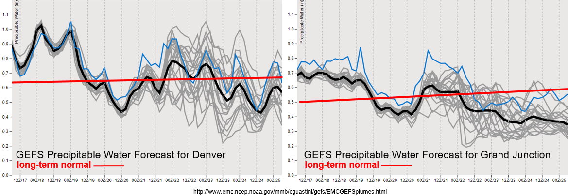
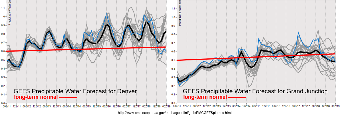
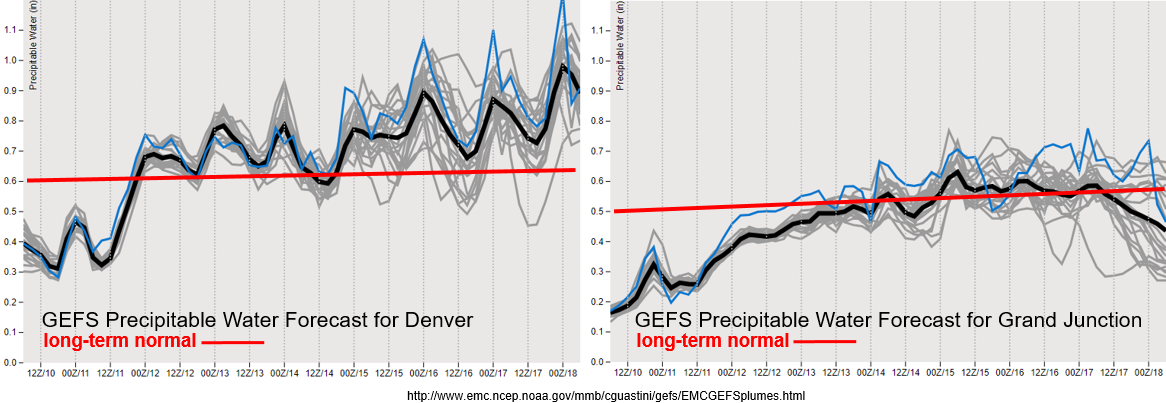
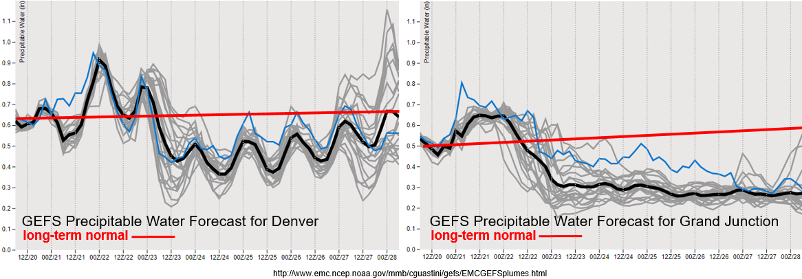
Quite the drop off in PW values between the last two systems. With southwesterly flow returning this afternoon, PW looks to increase statewide. This should cause an uptick in storm activity Friday and Saturday with slightly higher PW values predicted for eastern Colorado on Friday (Event #1). Thus, there is an Elevated flood threat with upper level dynamics also helping provide an environment favorable for severe weather. After Sunday, PW drops off to well below average statewide. With PW values around 0.3 inches over western Colorado throughout the week and a possible jet in the region by mid-week, fire conditions may be possible. This will be watched closely over the next week. A little higher moisture hangs on over eastern Colorado, but this will likely only provide fuel for some isolated, high-based thunderstorms during the afternoon hours favoring the high terrain with activity possibly spilling over into the adjacent plains with westerly steering winds. For Event #2 the spread in the PW values is too uncertain at this time. It is more likely that there be an increase in moisture over eastern Colorado with this pattern, but at this time there is No Apparent flood threat.

Snowpack:

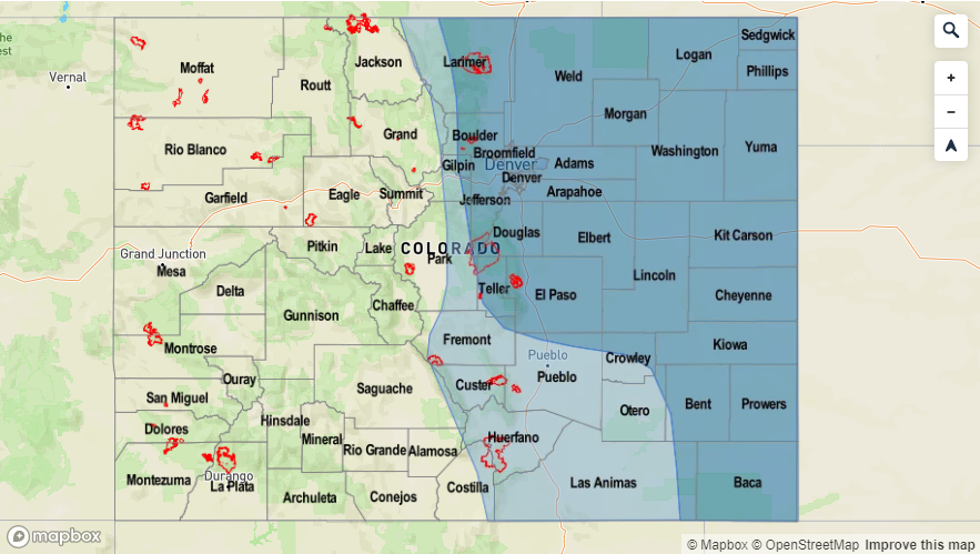
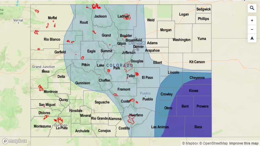
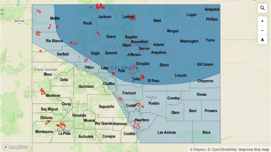
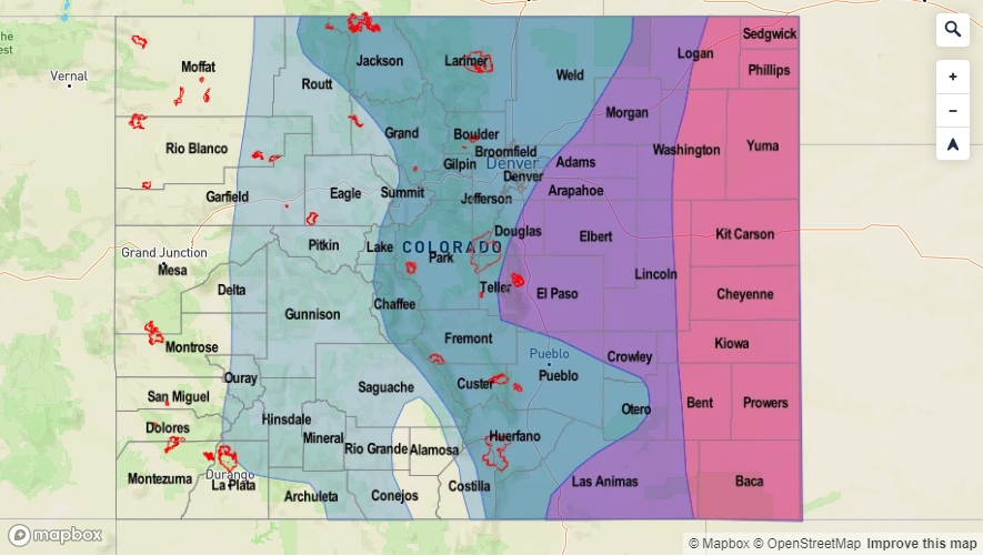
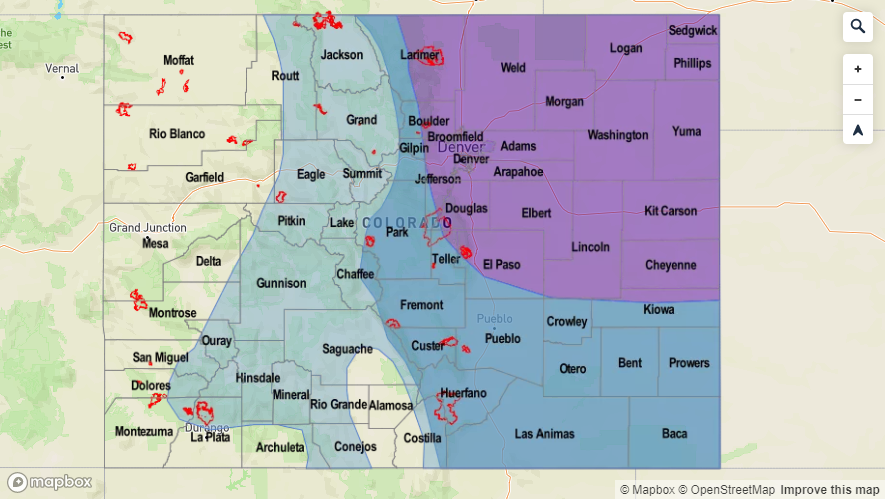
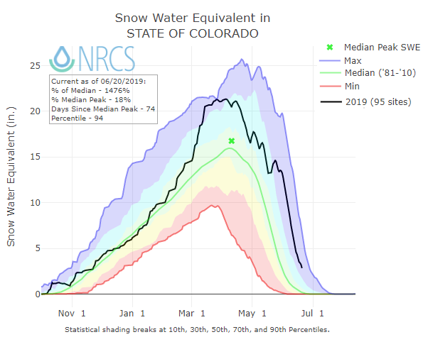
Much cooler temperatures over this next FTO with the passage of a strong cold front will likely slow down and maybe even stall the melting at the higher elevations. The latest SWE estimates for the state are shown below. Most basins have less than 5 inches of SWE left at their SNOTEL stations with some higher values to the north over the North Platte and Yampa/White river basins. It will be possible for the SNOTEL stations over the south to approach or reach zero by the end of next week. While no new flooding is anticipated, an Elevated flood threat still exits as many rivers will remain in Action stage over the next few days. Emergency management continues to report nuisance lowland flooding for the areas in the Low flood threat today (see FTB). For the latest information on the snowpack melt out, please tune into the daily FTB, your local NWS office or track the River Forecast Centers streamflow forecast here: AHPS gages (scroll over gage for forecast)


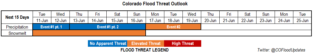
Event #1: Friday (6/21) – Sunday (6/23)

Elevated Threat/No Apparent Threat as upper dynamics, a cold front and high PW combine for severe weather and heavy rainfall.

A surface low will pull in some high moisture over eastern Colorado tomorrow afternoon. With a cold front dropping through the state and stalling during the afternoon and evening hours, convection initiating along the front is likely. Currently, projected soundings are showing high CAPE values, backing winds and a nice cold layer in the middle of the atmosphere. This should support supercell development with storms capable of producing large hail, strong winds and a tornado or two. With dew points in the 50°Fs and steering winds at about 15 knots, heavy rainfall will also be possible. Trailing storms oriented from the southwest corner to the northeast corner of the state along the stalled front will also likely produce some heavy rainfall totals by Saturday morning. Severe weather may be possible again on Saturday if clearing is able to occur over the Southeast Plains early enough in the day. Otherwise, storms should be confined to the mountains. The tornado threat would decrease Saturday as well as the heavy rainfall threat with faster steering flows and lower PW values over the eastern plains.

Legend


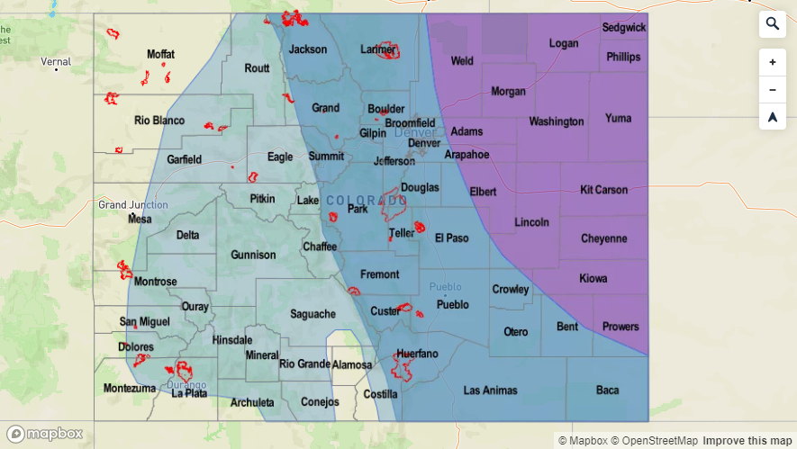
Event #2: Wednesday (6/26) – Sunday (6/30)

No Apparent Threat a ridge to our east and trough to our west place Colorado under southwest flow returning thunderstorms to the forecast.

The atmosphere will dry out a bit after Event #1 for this FTO. Models hint at the next system moving into the area sometime at the end of next week. PW values look to increase as southwesterly flow aloft returns to the state, but there is little confidence in the forecast this far out. Should the trough set up to our west and ridge to our east, there will likely be an increase in moisture over the eastern plains. This would allow upslope flow to initiate more widespread storms over the mountains during the afternoon and possible shortwaves enhancing activity. Some hot temperatures would also be likely if the 5880m isobar can reach the northern border. With so much uncertainty in the forecast, there is No Apparent threat at this time. As always, tune back into the FTO on Monday for the latest details.

Legend

FTO 06-17-2019: One more Day of an Elevated Flood Threat before Drier Air Moves in Between Systems

Issue Date: Monday, June 17th, 2019
Issue Time: 2:50PM MDT
Valid Dates: 6/18 – 7/2

Taking a look at the water vapor imagery below, a split pattern is occurring in the upper atmosphere to our west. With the high pressure well off the shore of CA, a weak trough has dropped south and settled over southern CA. Cut off from upper level support, this system will slowly transition eastward today through Wednesday bringing unsettled weather to the state. The trough and a surface low over eastern Colorado are pulling in very high PW values over northeastern/eastern Colorado. Forecasting this moisture to hold on another day for numerous scattered storms again tomorrow afternoon and an Elevated flood threat. Mid-level energy and moderate moisture holds on through Wednesday, but forecasting a large drop off in moisture as the flow aloft turns northwesterly behind the exiting trough.

Event #2 begins right after Event #1 on Thursday as a strong trough drops south and brushes the northern border of the state. Decent moisture begins to return to the northern portion of the state as flow turns more W/WSW, but with the jet in place, not expecting storms produce a heavy rainfall threat due to swift storm motion. The trough then digs back to the south and west, which will turn the flow aloft back to southwesterly on Friday. The trough will continue to sit to the west keeping unsettled weather across the state through Sunday. After the trough fully passes through the state late on Sunday night, northwesterly flow returns and another break in rainfall is anticipated.

The GEFS plumes still show much above average PW values for eastern and western Colorado through Tuesday. This should cause another round of widespread afternoon showers with an Elevated flood threat forecast. Storms tomorrow don’t seem to have quite as much instability as today either, expect over the far eastern plains, which could cause a couple severe thunderstorms. Storm motion to the west will be slightly faster than today, so not expecting heavy rainfall to be widespread, especially back to the west. With the severe storms over the Southeast Plains large hail, strong winds and local heavy rainfall will be main threats. Storms that track over burn areas tomorrow will also have the potential to cause flash flooding, so please tune into the FTB tomorrow morning for the latest.

By Wednesday, there is a large drop off in moisture both east and west of the Continental Divide as moisture gets scoured out with northwesterly flow aloft. Expecting some weak thunderstorm activity over the mountains during this period before there is another uptick in moisture as the trough drops south over Utah at the end of the work week. While there is still a large spread in moisture return for Event #2, it does not seem likely PW will return to above 1 inch except perhaps over the far eastern plains. Thus, there is No Apparent threat at this time. Details will continue to evolve so please tune back into the FTO on Thursday for the latest.

Snowpack:

With cooler temperatures for this next FTO due to the unsettled pattern, expect the rate of snowmelt to decrease a bit. This will likely translate to a decrease in flow over the southwest mountains and San Luis Valley. However, an Elevated flood threat has been issued since elevated flows are likely continue with many gages remaining in Action stage. Nighttime lows above freezing will continue to chip away at the remaining snowpack. Without any heavy rainfall forecast over these regions, swollen rivers should be able to absorb the minimal runoff. Therefore, the chance for an increase in riverine flooding is low. The once exception is just downstream of the Pueblo Dam where releases have been occurring over the last week and have been producing minor lowland flooding.

Event #1: Tuesday (6/18) – Wednesday (6/19)

Elevated Threat/No Apparent Threat as trough slowly moves to the east.

The tail-end of Event #1 from the last FTO will be Event #1 for this FTO. Afternoon and evening storm activity is expected to be widespread again tomorrow with high PW values remaining over the eastern plains. Over the Northeast Plains, instability will likely remain low with ongoing cloud cover from overnight convection. However, if clearing occurs, high rainfall will be likely again over saturated soils. This would increase runoff and the flood risk for this area. A couple severe storms may also be possible over the Southeast Plains with large hail, strong winds and heavy rainfall as the main threats. Burn areas will need to be monitored closely again tomorrow afternoon. Faster storm motion may limit the threat, but 1-hr rain rates up to 0.5 inches are forecast. This would likely be an issue if a storm tracks over a burn area, especially with rain falling over these areas today. Downtick in activity is forecast on Wednesday. Just expecting some weak thunderstorms over the mountains driven by the diurnal flow and some weak, mid-level energy.

Legend


Event #2: Thursday (6/20) – Sunday (6/23)

No Apparent Threat the next trough digs south over Utah and increases PW values with southwest flow aloft.

After the atmosphere dries out a bit, southwesterly flow will begin to increase moisture at the end of this week. Thus, there is an increase in activity forecast across the state going into next weekend. Lower moisture should keep the highest dew points to our east, so there is No Apparent threat for heavy rainfall. At this time, it looks like the heaviest accumulations will occur on Friday and Saturday. A cold front looks to drop south on Friday sometime between late afternoon and overnight. If timed correctly, this could bring some severe weather back into the forecast for the eastern plains. Not sure what moisture looks like behind the front, but it will likely increase shower coverage and accumulations on Saturday and lower high temperatures. Please tune back into the FTO on Thursday for the latest.

Legend

FTO 06-13-2019: Uptick in Storm Activity and Moisture over the Weekend with Minor Flooding Forecast over the San Juan Mountains, Southeast Mountains & San Luis Valley

Issue Date: Thursday, June 13th, 2019
Issue Time: 1:30PM MDT
Valid Dates: 6/14 – 6/28

Only 1 event for this next FTO with afternoon rainfall chances forecast to increase into this weekend. Taking a look at the water vapor imagery below, a weak and broad troughing pattern is present to our west. This pattern holds over the next week and will change the flow over the state from southwesterly to more westerly/northwesterly throughout the period. It will also push weak mid-level energy overhead time to time, which if timed correctly with peak heating will increase coverage of afternoon and evening storms. A cold front will drop over the plains on Saturday, and with the help of a surface low may cause some heavier showers overnight across the Southeast Plains. By Sunday, expect most of the plains to be capped under northerly surface flow, which should also keep afternoon showers confined to the higher terrains. After Tuesday, a stronger trough drops in from the north and pulls a very dry air mass overhead. This should limit afternoon rainfall to minimal amounts for the rest of the week.

As far as moisture, the GEFS plumes still shows an increase in moisture both east and west of the Continental Divide. Note: the image below is from the 00Z from the 11th as the GEFS on EMC hasn’t updated since then. The latest run of the GEFS indicates a surface low over the Texas Panhandle by Saturday evening, which should really ramp up the moisture over eastern Colorado. This may cause some heavy overnight rainfall as well over the plains. Moisture remains high over the eastern plains through Tuesday, so as storms move into this area with the westerly and northwest flow aloft, some heavy rainfall may be possible. Thus, there is an Elevated flood threat for Sunday into Tuesday. Storms will continue to have high-bases back to the west, which will likely increase the chances for gusty winds rather than heavy rainfall. There is some potential for some decent rain rates over the Southwest Mountains on Sunday and Monday, so please tune back into the FTB for the latest details as this may be problematic for recent burn areas.

Snowpack:

The snowpack continues to melt each day with consistently warmer temperatures and lows overnight failing to reach freezing. While not predicting any major riverine flooding this next week, it is likely more river gages will move into the Minor flooding stage. Expect all ongoing flooding to continue with more areas over the San Juan Mountains, San Luis Valley, south Central Mountains and Southeast Mountains reaching Action stage. The main threats for these new areas will be nuisance low land flooding. Over the last couple of days, gages along the upper Arkansas River have been on the rise. Minor flooding is predicted as early as tomorrow morning for Canon City. Threats include minor overbank flow in low-lying areas and water overtopping screens at the water supply intake in Canon City. The good news is that the current projections from the area River Forecast Centers (RFCs) show a decrease in water levels early next week over southwest Colorado. Also, heavy rainfall is not predicted over the mountains this weekend, so swollen rivers should be able to absorb most of the minimal runoff. Of course, this threat will be carefully monitored in the daily FTB. Overall, the Elevated threat hangs on for the next week as water levels will likely remain in the Action stage although levels will likely drop off over the southwest mountains.

Event #1: Friday (6/14) – Wednesday (6/19)

No Apparent Threat/Elevated Threat as broad troughs move through the area and moisture increases over the eastern plains.

An uptick in storm activity is forecast for this weekend when compared to the last couple of days. Moisture begins to return this afternoon both east and west of the Divide. While no pluvial flooding is forecast for the higher terrains, an uptick in moisture on Sunday and Monday over the Southeast Mountains could cause some flooding issues over recent burn scars even with steering flows around 15 knots. Higher moisture also creeps north and westward over the eastern plains beginning overnight on Saturday into Sunday. This will stick around through Tuesday, which may cause some severe thunderstorms over the eastern plains, which could potentially drop some heavy rainfall. Thus, there is an Elevated threat for this period. Details of the forecast will likely change and high PW values may not hang on through Tuesday over the eastern plains. Please tune back into the FTO on Monday for the latest.

Legend

FTO 06-10-2019: Afternoon Showers and Seasonal Temperatures Forecast with Minor Flooding Expected over the San Juan Mountains & San Luis Valley

Issue Date: Monday, June 10th, 2019
Issue Time: 2:30PM MDT
Valid Dates: 6/11 – 6/25

There will be a break in severe weather and heavy rainfall over the next couple of days as flow become more northwesterly (Event #1 pt. 1). The high pressure over Mexico will begin to shift back to the west and build a ridge over the Pacific Northwest. This will keep a strong surface high over the state and decrease upward motion. However, with northwesterly flow, there is a chance for passing shortwaves each day, so this may help spark some afternoon thunderstorm activity alongside the diurnal flow over the mountains. This upper level pattern will also push a weak cold front through the state Tuesday afternoon, so highs on Wednesday will be a couple of degrees cooler in the afternoon. When the front passes south, this will be the best chance for showers and weak thunderstorms for this portion of the event with activity centered over the Northeast Plains. Part 2 of Event #1 occurs as flow turns back to westerly/northwesterly with a weak trough forming over the west coast. This will start to increase moisture over the area, so expect an uptick in storm coverage into this weekend and a cold front to increase activity on Friday.

The trough pattern amplifies over the west coast towards the beginning of next week with the GFS placing a closed upper level low over southern CA (Event #2). At this time, the GFS indicates a weak ridge beginning to build over the state each afternoon. This would likely start to pull in high moisture values from the Gulf of Mexico into eastern Colorado with southeast surface flow, which will cause an Elevated flood threat for storms that move into the adjacent plains. As the low dips south before moving east, expect moisture to decrease across the state by mid-week. Thus, the threat for heavy rainfall will decrease sometime after Tuesday or Wednesday.

A very dry air mass is in place over Colorado, which can be seen by the below average PW values from the GEFS below. Overall, Wednesday should be the driest day of the week with only limited activity tomorrow afternoon over the Northeast Plains and Front Range. As the steering winds become more northwesterly, there is a slight increase in moisture. However, values still hover around average until Event #2 pt 2 where winds have more of a westerly component. As the moisture increases both east and west of the Continental Divide, expect an uptick in storm coverage over the mountains with activity spilling into the adjacent eastern plains for the end of this week. PW really starts to increase at the beginning of next week for eastern Colorado. A lot of this has to do with the placement of the ridge and Gulf of Mexico moisture. While there is some spread this far out, there is a clear trend for an increase in moisture. This will trigger the Elevated flood threat for eastern Colorado, although a lot can change this far out with slight movements in the upper level low. There is also a clear decrease in moisture to the west, due to the placement of the ridge.

Snowpack:

More seasonable temperatures are forecast this week, which means the melting will continue, but the rate of melting will decrease. Therefore, major riverine flooding this week (at higher elevations) is very unlikely. However, select small rivers and streams over the San Juan Mountains, San Luis Valley and Central Mountains as well as the headwaters of the Rio Grande and San Juan Rivers will continue to flood. There is an Elevated flood threat issued for these areas through the end of this week. As far as other locations, gages are beginning to increase to Action stage along the upper Arkansas River. Another place of interest is the Colorado River above Grand Junction, which will likely start to approach the Action stage by the end of this week. To the north, the North Platte River at Northgate will continue to rise, but Action Stage is not forecast this week. Lastly, anticipating another warm spell beginning at the beginning of next week, so minor flooding over the higher terrains could ramp up as early as mid-next week for the Arkansas River with the Colorado and North Platte not far behind. Please tune back into the FTO on Thursday for evolving details, and find the latest warnings and advisories in the daily FTB as well as from your local NWS office.

Event #1: Tuesday (6/11) – Sunday (6/16)

No Apparent Threat as minimal moisture and diurnal flow produce rounds of daily, afternoon storms.

A cold front drops through the state tomorrow afternoon, which will likely bring some weak thunderstorms and rainfall to the Northeast Plains during the afternoon. On Wednesday, cooler temperatures and a drier atmosphere under the northwesterly flow should only allow for isolated storms over the mountains. By Thursday, PW values are on the increase over the state through this weekend as flow turn to more westerly/northwesterly. This will cause an uptick in activity Friday into this weekend, with a lee trough setting up and pulling higher moisture on its east and north side into eastern Colorado. The cold front on Friday may also help produce some severe weather for the eastern plains. At this time, there is still minimal moisture, so just expecting moderate showers and weak thunderstorms (west) with isolated severe storms possible this weekend over eastern Colorado. Rain rates are expected to stay below flood threat criteria at this time, so there is no Elevated threat. This may easily change for the weekend as we move closer, so please tune back into the FTO on Thursday.

Legend

Event #2: Monday (6/17) – Wednesday (6/19)

Elevated Threat as PW begins to increase over eastern Colorado with a trough digging south over the west coast.

The start of Event #2 begins shortly after Event #1 as a stronger vorticity max dips into southern California. This will increase southwesterly flow over eastern Colorado and turn upper level flow to westerly over eastern Colorado. Over eastern Colorado, southwesterly surface winds will start to pull in high moisture from the Gulf of Mexico starting on Sunday; provided the low dips further south. With the GEFS also hinting at an upward trend in PW (close to 1 inch), an Elevated flood threat has been issued. With the upper trough approaching the state, upper dynamics may also create more widespread rainfall over eastern Colorado on Monday and Tuesday. This event is still far out, so please tune back in on Thursday for evolving and ever changing details.

Legend