Issue Date: Monday, June 17th, 2019
Issue Time: 2:50PM MDT
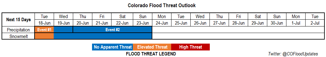
Valid Dates: 6/18 – 7/2
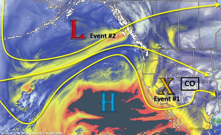
Taking a look at the water vapor imagery below, a split pattern is occurring in the upper atmosphere to our west. With the high pressure well off the shore of CA, a weak trough has dropped south and settled over southern CA. Cut off from upper level support, this system will slowly transition eastward today through Wednesday bringing unsettled weather to the state. The trough and a surface low over eastern Colorado are pulling in very high PW values over northeastern/eastern Colorado. Forecasting this moisture to hold on another day for numerous scattered storms again tomorrow afternoon and an Elevated flood threat. Mid-level energy and moderate moisture holds on through Wednesday, but forecasting a large drop off in moisture as the flow aloft turns northwesterly behind the exiting trough.
Event #2 begins right after Event #1 on Thursday as a strong trough drops south and brushes the northern border of the state. Decent moisture begins to return to the northern portion of the state as flow turns more W/WSW, but with the jet in place, not expecting storms produce a heavy rainfall threat due to swift storm motion. The trough then digs back to the south and west, which will turn the flow aloft back to southwesterly on Friday. The trough will continue to sit to the west keeping unsettled weather across the state through Sunday. After the trough fully passes through the state late on Sunday night, northwesterly flow returns and another break in rainfall is anticipated.
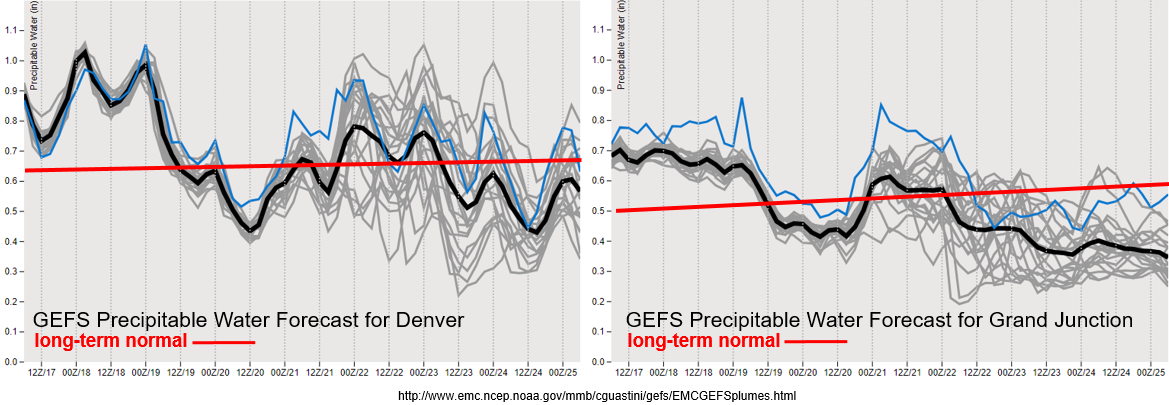
The GEFS plumes still show much above average PW values for eastern and western Colorado through Tuesday. This should cause another round of widespread afternoon showers with an Elevated flood threat forecast. Storms tomorrow don’t seem to have quite as much instability as today either, expect over the far eastern plains, which could cause a couple severe thunderstorms. Storm motion to the west will be slightly faster than today, so not expecting heavy rainfall to be widespread, especially back to the west. With the severe storms over the Southeast Plains large hail, strong winds and local heavy rainfall will be main threats. Storms that track over burn areas tomorrow will also have the potential to cause flash flooding, so please tune into the FTB tomorrow morning for the latest.
By Wednesday, there is a large drop off in moisture both east and west of the Continental Divide as moisture gets scoured out with northwesterly flow aloft. Expecting some weak thunderstorm activity over the mountains during this period before there is another uptick in moisture as the trough drops south over Utah at the end of the work week. While there is still a large spread in moisture return for Event #2, it does not seem likely PW will return to above 1 inch except perhaps over the far eastern plains. Thus, there is No Apparent threat at this time. Details will continue to evolve so please tune back into the FTO on Thursday for the latest.
Snowpack:
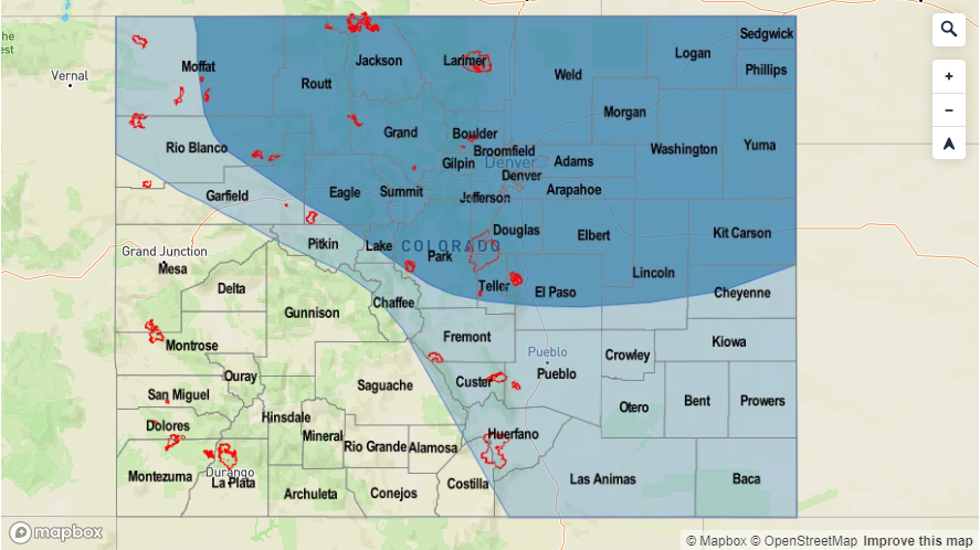
With cooler temperatures for this next FTO due to the unsettled pattern, expect the rate of snowmelt to decrease a bit. This will likely translate to a decrease in flow over the southwest mountains and San Luis Valley. However, an Elevated flood threat has been issued since elevated flows are likely continue with many gages remaining in Action stage. Nighttime lows above freezing will continue to chip away at the remaining snowpack. Without any heavy rainfall forecast over these regions, swollen rivers should be able to absorb the minimal runoff. Therefore, the chance for an increase in riverine flooding is low. The once exception is just downstream of the Pueblo Dam where releases have been occurring over the last week and have been producing minor lowland flooding.
Event #1: Tuesday (6/18) – Wednesday (6/19)
Elevated Threat/No Apparent Threat as trough slowly moves to the east.
The tail-end of Event #1 from the last FTO will be Event #1 for this FTO. Afternoon and evening storm activity is expected to be widespread again tomorrow with high PW values remaining over the eastern plains. Over the Northeast Plains, instability will likely remain low with ongoing cloud cover from overnight convection. However, if clearing occurs, high rainfall will be likely again over saturated soils. This would increase runoff and the flood risk for this area. A couple severe storms may also be possible over the Southeast Plains with large hail, strong winds and heavy rainfall as the main threats. Burn areas will need to be monitored closely again tomorrow afternoon. Faster storm motion may limit the threat, but 1-hr rain rates up to 0.5 inches are forecast. This would likely be an issue if a storm tracks over a burn area, especially with rain falling over these areas today. Downtick in activity is forecast on Wednesday. Just expecting some weak thunderstorms over the mountains driven by the diurnal flow and some weak, mid-level energy.

Event #2: Thursday (6/20) – Sunday (6/23)
No Apparent Threat the next trough digs south over Utah and increases PW values with southwest flow aloft.
After the atmosphere dries out a bit, southwesterly flow will begin to increase moisture at the end of this week. Thus, there is an increase in activity forecast across the state going into next weekend. Lower moisture should keep the highest dew points to our east, so there is No Apparent threat for heavy rainfall. At this time, it looks like the heaviest accumulations will occur on Friday and Saturday. A cold front looks to drop south on Friday sometime between late afternoon and overnight. If timed correctly, this could bring some severe weather back into the forecast for the eastern plains. Not sure what moisture looks like behind the front, but it will likely increase shower coverage and accumulations on Saturday and lower high temperatures. Please tune back into the FTO on Thursday for the latest.