Issue Date: Monday, June 10th, 2019
Issue Time: 2:30PM MDT
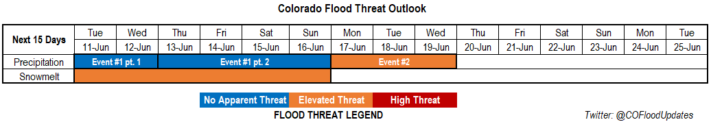
Valid Dates: 6/11 – 6/25
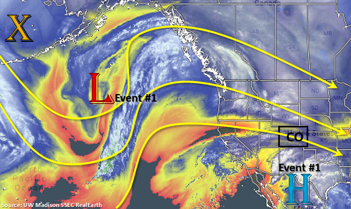
There will be a break in severe weather and heavy rainfall over the next couple of days as flow become more northwesterly (Event #1 pt. 1). The high pressure over Mexico will begin to shift back to the west and build a ridge over the Pacific Northwest. This will keep a strong surface high over the state and decrease upward motion. However, with northwesterly flow, there is a chance for passing shortwaves each day, so this may help spark some afternoon thunderstorm activity alongside the diurnal flow over the mountains. This upper level pattern will also push a weak cold front through the state Tuesday afternoon, so highs on Wednesday will be a couple of degrees cooler in the afternoon. When the front passes south, this will be the best chance for showers and weak thunderstorms for this portion of the event with activity centered over the Northeast Plains. Part 2 of Event #1 occurs as flow turns back to westerly/northwesterly with a weak trough forming over the west coast. This will start to increase moisture over the area, so expect an uptick in storm coverage into this weekend and a cold front to increase activity on Friday.
The trough pattern amplifies over the west coast towards the beginning of next week with the GFS placing a closed upper level low over southern CA (Event #2). At this time, the GFS indicates a weak ridge beginning to build over the state each afternoon. This would likely start to pull in high moisture values from the Gulf of Mexico into eastern Colorado with southeast surface flow, which will cause an Elevated flood threat for storms that move into the adjacent plains. As the low dips south before moving east, expect moisture to decrease across the state by mid-week. Thus, the threat for heavy rainfall will decrease sometime after Tuesday or Wednesday.
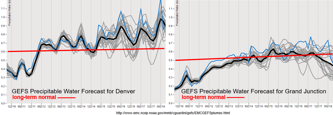
A very dry air mass is in place over Colorado, which can be seen by the below average PW values from the GEFS below. Overall, Wednesday should be the driest day of the week with only limited activity tomorrow afternoon over the Northeast Plains and Front Range. As the steering winds become more northwesterly, there is a slight increase in moisture. However, values still hover around average until Event #2 pt 2 where winds have more of a westerly component. As the moisture increases both east and west of the Continental Divide, expect an uptick in storm coverage over the mountains with activity spilling into the adjacent eastern plains for the end of this week. PW really starts to increase at the beginning of next week for eastern Colorado. A lot of this has to do with the placement of the ridge and Gulf of Mexico moisture. While there is some spread this far out, there is a clear trend for an increase in moisture. This will trigger the Elevated flood threat for eastern Colorado, although a lot can change this far out with slight movements in the upper level low. There is also a clear decrease in moisture to the west, due to the placement of the ridge.
Snowpack:
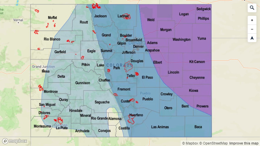
More seasonable temperatures are forecast this week, which means the melting will continue, but the rate of melting will decrease. Therefore, major riverine flooding this week (at higher elevations) is very unlikely. However, select small rivers and streams over the San Juan Mountains, San Luis Valley and Central Mountains as well as the headwaters of the Rio Grande and San Juan Rivers will continue to flood. There is an Elevated flood threat issued for these areas through the end of this week. As far as other locations, gages are beginning to increase to Action stage along the upper Arkansas River. Another place of interest is the Colorado River above Grand Junction, which will likely start to approach the Action stage by the end of this week. To the north, the North Platte River at Northgate will continue to rise, but Action Stage is not forecast this week. Lastly, anticipating another warm spell beginning at the beginning of next week, so minor flooding over the higher terrains could ramp up as early as mid-next week for the Arkansas River with the Colorado and North Platte not far behind. Please tune back into the FTO on Thursday for evolving details, and find the latest warnings and advisories in the daily FTB as well as from your local NWS office.
Event #1: Tuesday (6/11) – Sunday (6/16)
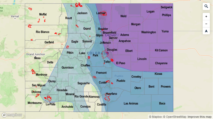
No Apparent Threat as minimal moisture and diurnal flow produce rounds of daily, afternoon storms.
A cold front drops through the state tomorrow afternoon, which will likely bring some weak thunderstorms and rainfall to the Northeast Plains during the afternoon. On Wednesday, cooler temperatures and a drier atmosphere under the northwesterly flow should only allow for isolated storms over the mountains. By Thursday, PW values are on the increase over the state through this weekend as flow turn to more westerly/northwesterly. This will cause an uptick in activity Friday into this weekend, with a lee trough setting up and pulling higher moisture on its east and north side into eastern Colorado. The cold front on Friday may also help produce some severe weather for the eastern plains. At this time, there is still minimal moisture, so just expecting moderate showers and weak thunderstorms (west) with isolated severe storms possible this weekend over eastern Colorado. Rain rates are expected to stay below flood threat criteria at this time, so there is no Elevated threat. This may easily change for the weekend as we move closer, so please tune back into the FTO on Thursday.

Event #2: Monday (6/17) – Wednesday (6/19)
Elevated Threat as PW begins to increase over eastern Colorado with a trough digging south over the west coast.
The start of Event #2 begins shortly after Event #1 as a stronger vorticity max dips into southern California. This will increase southwesterly flow over eastern Colorado and turn upper level flow to westerly over eastern Colorado. Over eastern Colorado, southwesterly surface winds will start to pull in high moisture from the Gulf of Mexico starting on Sunday; provided the low dips further south. With the GEFS also hinting at an upward trend in PW (close to 1 inch), an Elevated flood threat has been issued. With the upper trough approaching the state, upper dynamics may also create more widespread rainfall over eastern Colorado on Monday and Tuesday. This event is still far out, so please tune back in on Thursday for evolving and ever changing details.