Issue Date: Thursday, June 13th, 2019
Issue Time: 1:30PM MDT
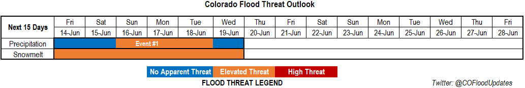
Valid Dates: 6/14 – 6/28
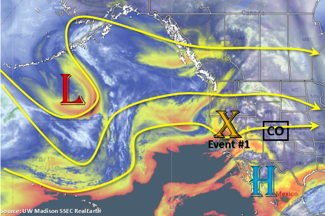
Only 1 event for this next FTO with afternoon rainfall chances forecast to increase into this weekend. Taking a look at the water vapor imagery below, a weak and broad troughing pattern is present to our west. This pattern holds over the next week and will change the flow over the state from southwesterly to more westerly/northwesterly throughout the period. It will also push weak mid-level energy overhead time to time, which if timed correctly with peak heating will increase coverage of afternoon and evening storms. A cold front will drop over the plains on Saturday, and with the help of a surface low may cause some heavier showers overnight across the Southeast Plains. By Sunday, expect most of the plains to be capped under northerly surface flow, which should also keep afternoon showers confined to the higher terrains. After Tuesday, a stronger trough drops in from the north and pulls a very dry air mass overhead. This should limit afternoon rainfall to minimal amounts for the rest of the week.
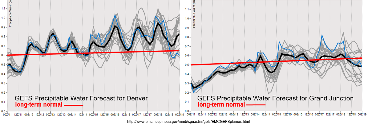
As far as moisture, the GEFS plumes still shows an increase in moisture both east and west of the Continental Divide. Note: the image below is from the 00Z from the 11th as the GEFS on EMC hasn’t updated since then. The latest run of the GEFS indicates a surface low over the Texas Panhandle by Saturday evening, which should really ramp up the moisture over eastern Colorado. This may cause some heavy overnight rainfall as well over the plains. Moisture remains high over the eastern plains through Tuesday, so as storms move into this area with the westerly and northwest flow aloft, some heavy rainfall may be possible. Thus, there is an Elevated flood threat for Sunday into Tuesday. Storms will continue to have high-bases back to the west, which will likely increase the chances for gusty winds rather than heavy rainfall. There is some potential for some decent rain rates over the Southwest Mountains on Sunday and Monday, so please tune back into the FTB for the latest details as this may be problematic for recent burn areas.
Snowpack:
The snowpack continues to melt each day with consistently warmer temperatures and lows overnight failing to reach freezing. While not predicting any major riverine flooding this next week, it is likely more river gages will move into the Minor flooding stage. Expect all ongoing flooding to continue with more areas over the San Juan Mountains, San Luis Valley, south Central Mountains and Southeast Mountains reaching Action stage. The main threats for these new areas will be nuisance low land flooding. Over the last couple of days, gages along the upper Arkansas River have been on the rise. Minor flooding is predicted as early as tomorrow morning for Canon City. Threats include minor overbank flow in low-lying areas and water overtopping screens at the water supply intake in Canon City. The good news is that the current projections from the area River Forecast Centers (RFCs) show a decrease in water levels early next week over southwest Colorado. Also, heavy rainfall is not predicted over the mountains this weekend, so swollen rivers should be able to absorb most of the minimal runoff. Of course, this threat will be carefully monitored in the daily FTB. Overall, the Elevated threat hangs on for the next week as water levels will likely remain in the Action stage although levels will likely drop off over the southwest mountains.
Event #1: Friday (6/14) – Wednesday (6/19)
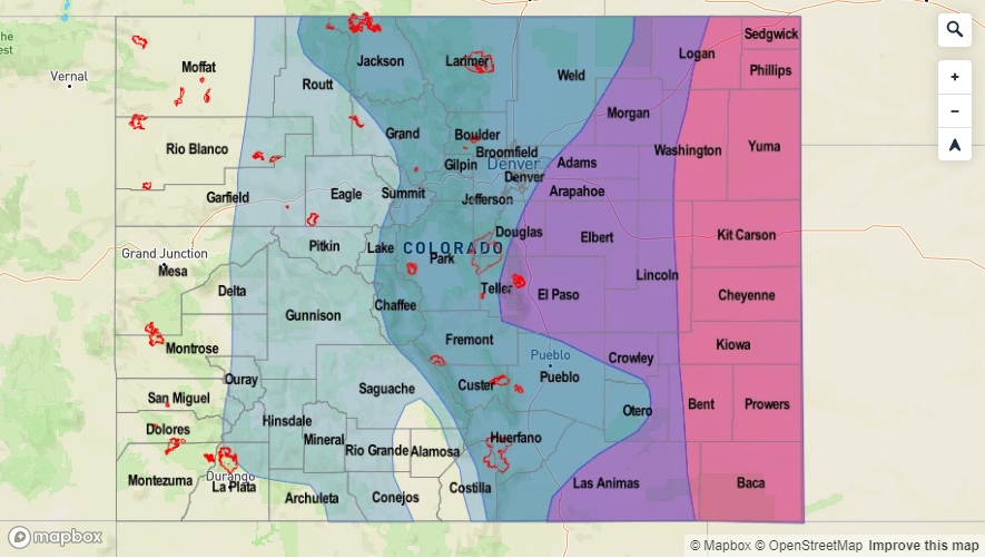
No Apparent Threat/Elevated Threat as broad troughs move through the area and moisture increases over the eastern plains.
An uptick in storm activity is forecast for this weekend when compared to the last couple of days. Moisture begins to return this afternoon both east and west of the Divide. While no pluvial flooding is forecast for the higher terrains, an uptick in moisture on Sunday and Monday over the Southeast Mountains could cause some flooding issues over recent burn scars even with steering flows around 15 knots. Higher moisture also creeps north and westward over the eastern plains beginning overnight on Saturday into Sunday. This will stick around through Tuesday, which may cause some severe thunderstorms over the eastern plains, which could potentially drop some heavy rainfall. Thus, there is an Elevated threat for this period. Details of the forecast will likely change and high PW values may not hang on through Tuesday over the eastern plains. Please tune back into the FTO on Monday for the latest.