FTO 07-04-2019: Elevated Rainfall and Riverine Flood Threat for the Holiday Weekend

Issue Date: Thursday, July 4th, 2019
Issue Time: 1:45PM MDT
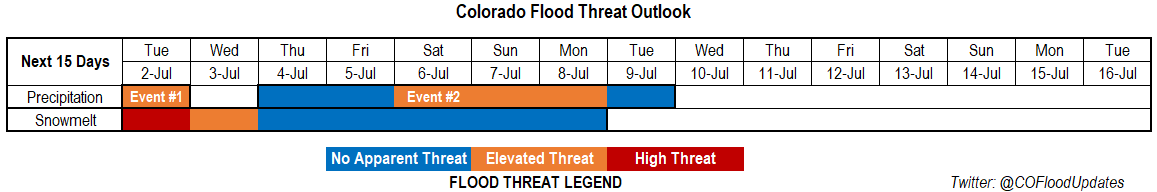
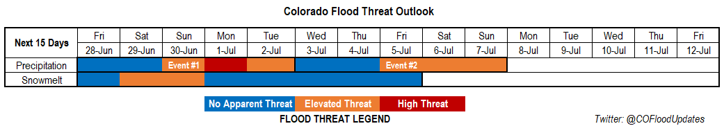
Valid Dates: 7/5 – 7/19

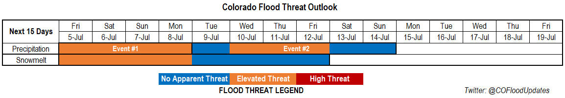
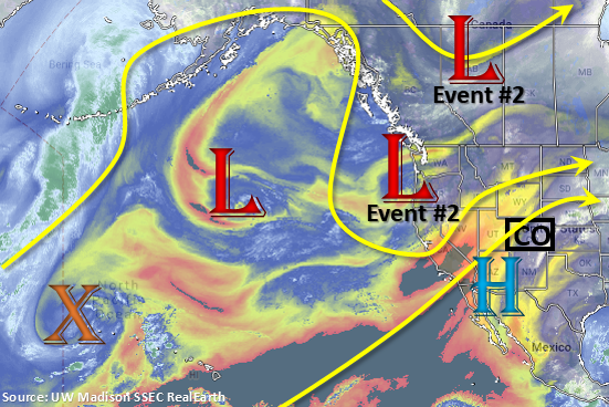
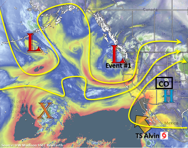
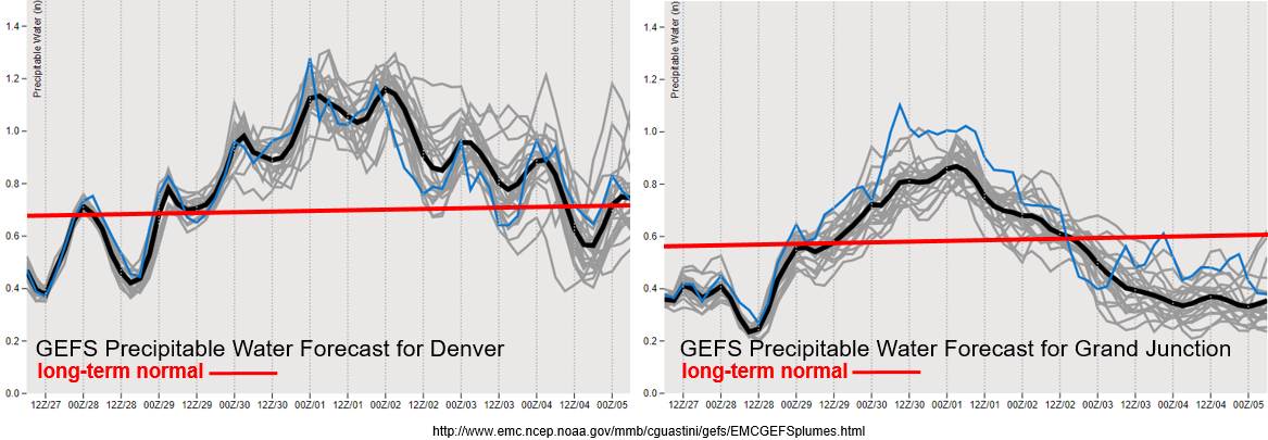
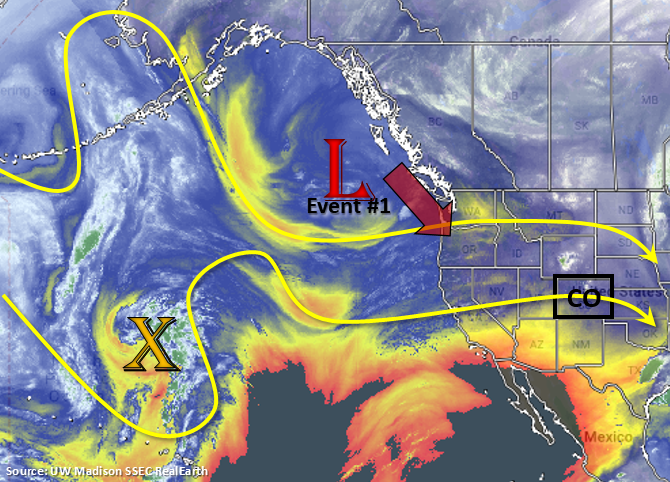
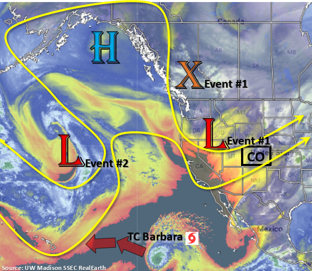
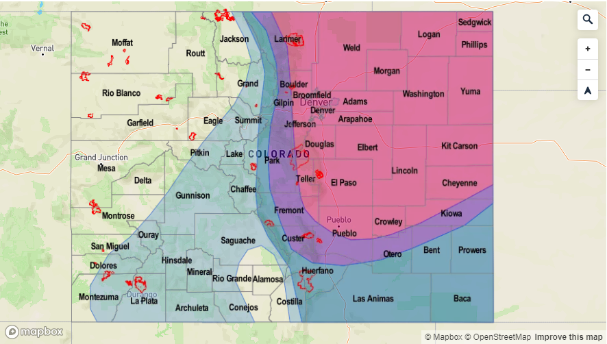
There are two events identified for this next FTO. Event #1 is broken down into two features, which are marked in the water vapor imagery below. Today into tomorrow, the upper level low will progress eastward and breakdown the ridge. This will allow some moisture to move in from the Pacific over eastern Colorado. Post frontal upslope flow will also help moisten the lower atmosphere tomorrow and mid-level energy associated with the trough will help provide more widespread coverage of storms. The vorticity max (orange “X”) then moves slightly to the west and deepens off the Pacific Northwest coast. This will allow the ridge to begin to build over Colorado again. The axis of the ridge will be in a favorable location for another PW surge both east and west of Colorado. This should return showers to at least the southern high terrain over the western slope and reduce critical fire weather this weekend.

Tuesday expecting a break in heavy rainfall as the trough full pushes to our east and the ridge positions itself in a way that allows the atmosphere dry out a bit (westerly flow aloft). Event #2 begins by Wednesday as the next upper trough moves over the Pacific Northwest. As the trough slowly traverses to the east, it will push the ridge with it allowing the next PW surge to occur. By next weekend, models build another ridge, but further to the west, which should reduce the chances of heavy rainfall. There is lower confidence in the forecast this far out for Event #2, so please tune back into the FTO next Monday.

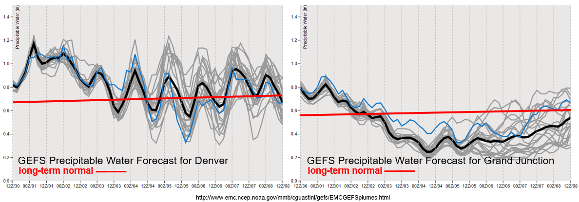
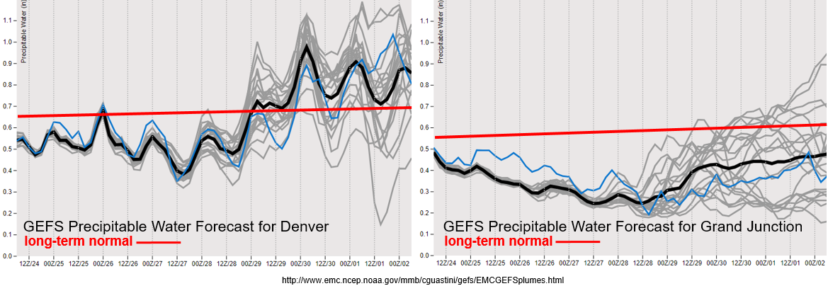
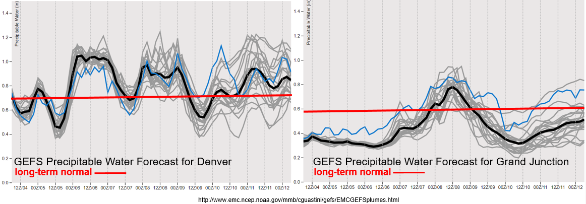
Looking at the GEFS PW plumes below, you can see some nice moisture surges that are associated with the ridge axis movement. Over eastern Colorado, the front passing through overnight on Thursday should help increase low level moisture for more widespread storms tomorrow. There is another PW surge on Saturday, which occurs both east and west of the Divide reinforced by northerly surface flow Friday night. With the high over the New Mexico area, better moisture can be pulled into western Colorado. This should increase the chances for rainfall on Saturday over the southern high terrains (west) and increase the threat over recent burn areas (west and east). With long spells of moisture over eastern Colorado, expect some fog, cloud cover and light rain Friday and Saturday morning as well. This could decrease the chances for afternoon storms over the plains by capping the area (preventing instability from forming). After this weekend, quite a bit of disagreement between the model members, but there does seems to be a trend for an increase in PW values by mid next week. This would mark the beginning of Event #2.

Snowpack/Riverine:

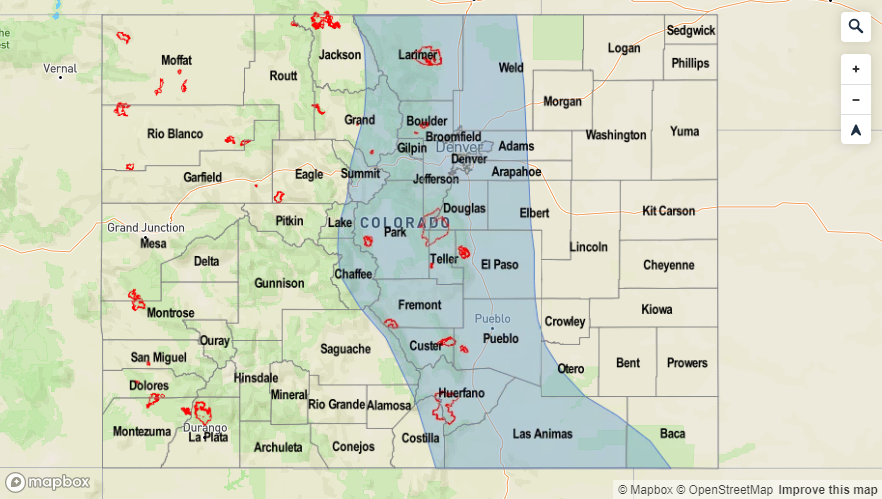
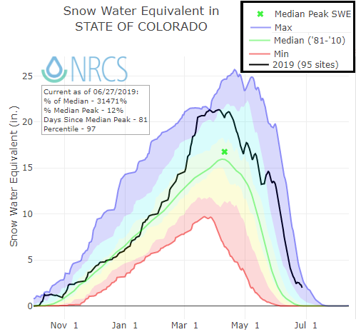
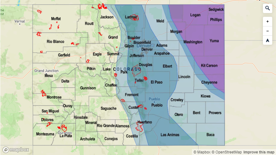
As anticipated, there has been another peak in flow this week from warmer temperatures (snowmelt), dam releases and multiple days of rainfall at the beginning of the week. There is an Elevated threat through Monday due to the dam releases and high flows. Minor flooding is anticipated to over low lying areas, but banks will also become unstable from the swift currents. Please use extra caution with water activities as dam releases and high flows can dislodge debris and cause waters to rapidly rise. Beginning tomorrow, most rivers show a decrease in streamflow, which should start to drop gages below the Action stage. However, if a storms on Saturday and Sunday track over the same area around a high flow, there may be an increase flood threat. There is currently only one Flood Warning near the Avondale gage on the Arkansas River downstream of Pueblo Dam. This is due to a recent release from the dam. This will likely push the La Junta gage back into Action stage as early as this afternoon with a peak in flow forecast on Saturday afternoon. For the latest on the riverine flood threat, check out the real-time AHPS gage heights and follow your local NWS office for all Flood Warnings and Advisories. Note: all NWS Flood Advisories and Warnings will be mentioned in the daily FTB that are active at the posting time.

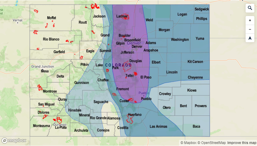
Event #1: Friday (7/5) – Monday (7/8)

Elevated Threat as low level moisture surges over Colorado as the ridge is broken down by a trough moving to the east.  

Friday morning will begin a little bit cloudy and foggy for eastern Colorado due to extra moisture available from the passing of a front overnight. This should reduce temperatures over eastern Colorado, although it will still be quite hot by tomorrow afternoon. Post frontal upslope flow is forecast to initiate widespread showers and thunderstorms tomorrow afternoon and overnight. Burn areas over the Southeast Mountains look to stay mostly rain free and the far eastern plains looked capped, so highest rainfall accumulates are expected to be over the Front Range, Palmer Ridge and Urban Corridor.

Saturday, storms are forecast to return to the southern high terrains of western Colorado with widespread thunderstorm and rainfall activity over eastern Colorado as well. Storms will begin in the morning with stronger thunderstorms possible over the Raton Ridge and Southeast Plains during the afternoon and evening. Flooding may also be possible over the Junkins, Hayden Pass and Spring Creek burn areas, so tune back in to the FTB on Saturday morning to monitor the threat. Sunday and Monday, afternoon storms over the mountains and adjacent plains will be possible again. With high PW values through this period, the entire event has an Elevated flood threat. Decent steering flow should keep storms from dropping too much rain over one place, but back building storms may cause increased accumulations as well as longer duration moderate rainfall. We will be watching high flows on rivers and creeks closely as storms that track of the same area 2 or more days in a row may cause some minor flooding issues, which would be similar to last week.

Legend

Event #2: Tuesday (7/9) – Sunday (7/14)

No Apparent Threat/Elevated Threat as the next trough pushes the ridge axis to the east and creates another moisture surge from the Pacific and Gulf of Mexico.

Still have lower confidence in this event as the next trough sets up over the Pacific Northwest and allows the ridge to rebuild over the state. There will be a break in heavy rainfall on Tuesday between the two systems, but there will likely be enough residual moisture under the ridge for more isolated showers and thunderstorms during the afternoon that are diurnal driven. With the potential placement of the high over New Mexico, this would also return the chance of rain and thunderstorms to western Colorado. Wouldn’t say the monsoon has set up just yet, even though we are getting these PW surges. Models are (fairly consistently) starting to set up the 500mb high in the correct place by mid-July. So the waiting game begins.

Legend

FTO 07-01-2019: Heavy Rainfall for One More Day, then a Break in Activity Until the Holiday Weekend

Issue Date: Monday, July 1st, 2019
Issue Time: 2:35PM MDT
Valid Dates: 7/2 – 7/16

With the jet well to the north, an off and off ridging pattern will set up over the state. The first event of this FTO will be the last day from Event #1 from Thursday’s FTO. The weak ridging pattern present today is expected to persist through tomorrow. This atmospheric pattern, with the ridge axis slightly to the east, has funneled in a very moist air mass over eastern Colorado. There is a break after Event #1 as the ridge builds north and west of the state on Wednesday. Outside of some weak, high elevation storms with the diurnal flow, it should be a pleasant and warm day.

By Thursday, Event #2 begins as an upper level low over the Pacific Northwest drops south and moves east into the desert southwest. This will return southwest flow aloft and help rotate some mid-level energy across the state each afternoon, which should help increase the coverage of storms over the mountains and adjacent plains. Additional thunderstorm activity will be possible over the eastern plains with a lee trough setting up on Thursday and Friday. By Saturday, the next surge of low level moisture occurs as the next low over the Pacific Northwest pushes east. With slight eastward movement of the ridge, surface flow will again tap into Gulf of Mexico moisture. Models are also hinting at a cold front dropping through the state on Friday night, which should help increase low level moisture over the area for an increase in storm activity on Saturday over the mountains. Thus, there is an Elevated Threat from Saturday to Monday before northwest flow begins to push the high moisture south and east. Another cold front looks to drop through the state on Tuesday or Wednesday thanks to the northwest flow aloft. Models showing more stability behind this feature, so storm activity should then be isolated and confined to the eastern mountains.

We’re nearing the point in time that PW values have a quick increase in climatology, which marks the onset of the North American Monsoon (NAM). Models are beginning to hint at the NAM regime taking over about 1.5 to 2 weeks from now. For this FTO, the GEFS PW plumes are showing quite the active pattern over the next week east of the Continental Divide. Tomorrow, PW values look to hang on at or slight above 1 inch. With slow steering winds in place for another day, an Elevated flood threat has been issued. PW values diverge from member to member after Wednesday, which shows the uncertainty for Event #2. However, with the upward trend in the models going into the holiday weekend, an Elevated flood threat has been issued for Saturday, Sunday and Monday.

To the west, remnants of Alvin are pushed out of the area with dry southwest flow rather rapidly. This will decrease PW values to well below climatology and limit the chances for measurable rain until this weekend. These dry spells and lack of rainfall are not too uncommon for the area this time of year, since the majority of western Colorado receives the bulk of its precipitation during July and August from the NAM. With a southwest to northeast oriented jet near the western border on Thursday and Friday, there may be increase in fire danger.

Snowpack:

As anticipated, the RFCs (River Forecast Centers) forecast of higher streamflows this weekend into this week came to fruition. This was partially due to snowmelt and partially due to widespread rain yesterday adding to the swollen rivers. Additionally, there was a release at Pueblo Dam, which cause some minor lowland flooding at Avondale. Runoff from yesterdays’ storms really spiked some gages, so with heavier rainfall anticipated today, another round of storms tomorrow and saturated soils, a High threat has been issued for bankfull, high elevation streams and rivers. This includes the upper Colorado and Arkansas Rivers. While only minor lowland flooding is anticipated, the swift movement of the rivers will likely cause banks to become unstable and increase debris in the water. Please use extreme caution this next week with all water activities. For the latest on the riverine flood threat, check out the real-time AHPS gage heights and follow your local NWS office for warnings and advisories.

Event #1: Tuesday (7/2)

Elevated Threat as low level moisture remains over eastern Colorado and slow steering winds will promote local heavy rainfall for another day.  

Storms for the most part will be confined to the higher terrains tomorrow. There will likely be some activity over the adjacent eastern plains along the Palmer and Raton Ridges. Without any extra mid-level energy, the mountains and ridges will provide the lift for the storms. Rainfall rates will likely be more gradual than today, so widespread flooding is not anticipated. However, rain rates are expected to be high enough to cause flooding issues over recent burn scars in the Southeast Mountains. These areas will be susceptible to flash flooding and mud flows/debris slides for one more day. Please tune into the FTB tomorrow for more details. Elsewhere over the mountains, expect an increase in runoff due to two days of rainfall. This will also increase the chances for mud flows and debris slides under stronger storms. High rivers and streams should also be monitored closely, and extreme caution should be used around high and rushing water as banks are likely unstable.

Legend

Event #2: Thursday (7/4) – Tuesday (7/9)

No Apparent Threat/Elevated Threat southwest flow returns and a push of the ridge eastwards allows Gulf of Mexico moisture to return to the eastern plains.

Quite a bit of divergence in the models and members for this weekend, but with a trend of an upward tick in moisture, there will be an Elevated flood threat for the 4th of July weekend. A ridge begins to build over the state for the first part of the week. Then as the ridge is pushed east with the trough, an influx of higher PW values over eastern Colorado will be likely. A lee trough sets up on Thursday and Friday, so some severe weather may be possible along the eastern border. The main threats will be gusty winds and large hail. Hard to tell where the moisture will set up over the eastern plains, but storms in the area will likely produce at least moderate rainfall rates with a chance for heavy rainfall. Post frontal upslope flow on Saturday should cause more numerous storms over the mountains, but activity is not anticipated for the adjacent plains at this time. Storm activity on Sunday and Monday is forecast to spill into the adjacent plains with stronger steering flows and an increase in mid-level energy. Please tune back into the FTO on Thursday as models will come into better agreement for the pattern this weekend.

Legend

FTO 06-27-2019: Heavy Rainfall Anticipated as High Precipitable Water Values Are Pulled into Colorado

Issue Date: Thursday, June 27th, 2019
Issue Time: 2:45PM MDT
Valid Dates: 6/28 – 7/12

Looks like that summer atmospheric pattern is finally here to stay. The polar jet has finally pulled to the north, which has allowed some very hot temperatures to fester over the state since Monday. The 5580m line (weak ridge) will remain well to the north of the state through next Monday with the main axis to our east. This will continue southwest flow aloft and keep hot temperatures in the forecast through this weekend. Movement of the axis further east will allow ample low level moisture to return to the state, and may pull in remnants of Tropical Storm Alvin (off the coast of Mexico) over the southwest corner of the state as soon as Friday. By Sunday evening, flow will start to become more zonal as the ridge breaks down, and a weak cold front will pass through the state overnight. Westerly flow aloft through Tuesday will keep high PW values over eastern Colorado. Flow aloft turns to the northwest after Tuesday, which should end Event #1.

Not much, if any time between Event #1 and Event #2. Ample moisture remains in place after Tuesday for scattered afternoon storms, but the flood threat should decrease. By the holiday weekend, the upper level ridge will set back up with the ridge of the axis possibility setting up to the east once again. This would allow low level moisture to rotate around the high and return the flood threat. Still quite a bit of uncertainty at this time, but overall, doesn’t look like there will be much dry or too cool of temperatures this next forecast period.

PW values look to increase statewide to much above average values for this time of year by this weekend, and then last through next Tuesday. Monday’s FTO’s PW values showed an increase, but not with the certainty, magnitude and timing of the latest GEFS runs. This will return the flood threat both east and west of the Continental Divide and increase the threat level to an Elevated/High threat at the end of this weekend. It has been dry and hot over western Colorado with critical fire weather yesterday, today and again tomorrow. The absorption of moisture into the westerly flow from Tropical Storm Alvin over southwest CO begins on Friday, which should reduce fire danger and increase the chances for measurable rain this weekend. The 416 burn area will be monitored closely due to the uptick in moisture from Saturday to Monday. To the east, PW values peak well above the 1 inch mark on Sunday and Monday. Reminder that the 1 inch PW value is a good indicator of heavy rainfall if both lift and instability are also available. Slow steering winds under the ridge over eastern Colorado will also allow storms to drop heavier accumulations. Recent burn areas will be extra susceptible to flooding during Event #1. After Monday, dry weather is expected to return to western Colorado with the ridge axis to our west. Moisture will also briefly decrease to more seasonable values over eastern Colorado, so there is No Apparent Threat at this time.

Snowpack:

The flooding threat has decreased over the state the last couple of days with only one gage remaining at Action stage this morning (Rio Grande at Alamosa). The flow is anticipated to remain steady at the gage with only a slight increase this weekend thanks to multiple days of hot temperatures. Taking a look at the statewide SWE below, you can pick out the spring snow storms that have occurred over the last couple months and have stalled the melting process (and even added to SWE). While we will come close to the 1995 record for longest lasting SWE, we likely won’t beat it with summerlike temperatures forecast. RFCs (River Forecast Centers) are forecasting another rise in smaller, high-elevation rivers and streams by later this weekend, which may cause a couple AHPS gages to reach Action stage. Rain forecasts will be monitored closely during this peak as some heavier, widespread rainfall will be possible. This may cause some minor flooding issues while the rivers are swollen from snowmelt, but at this time, no major riverine flooding is anticipated. As anticipated, there are currently no NWS Areal Flood Advisories or Warnings. This will likely be the last FTO with the snowpack update, but riverine flooding will continue to be monitored throughout the season.

Event #1: Friday (6/28) – Tuesday (7/2)

No Apparent Threat High Threat as eastward movement of a weak ridge allows ample low level moisture from the Gulf of Mexico and Tropical Storm Alvin to move into the state.

Deep moisture will return to the state beginning this weekend. This will return the flood threat as heavy rainfall with slow steering winds combine for a High threat on Monday. Storms will initiate over the mountains each afternoon and will likely be confined to that area and immediate adjacent plains through this event. The main reason for this is the only forcing mechanism available will be the diurnal upslope pattern. Storms will likely survive best over the Palmer and Raton Ridges as they move east. By Sunday, storms over the mountains will be capable of producing widespread, heavy rainfall with very high PW values anticipated over the state. This could easily cause some flooding issues, especially over recent burn scars in the Southeast Mountains and San Juan/Central Mountains. Thunderstorms chances increase for the plains on Monday and Tuesday. These storms will also be capable of producing heavy rainfall as well as some severe weather over the Northeast Plains thanks to passing cold fronts adding dynamics to the atmosphere. Still quite a bit of uncertainty with how each day will unfold Sunday-Tuesday, so please tune back into the daily FTB for the latest details.

Legend


Event #2: Wednesday (7/3) – Sunday (7/7)

No Apparent Threat/Elevated Threat northwest flow brings a brief break in heavy rainfall before the next ridge sets up and potentially shifts slightly to the east allowing gulf moisture to increase over eastern Colorado.

Models hint at a ridge rebuilding north of Colorado for the holiday weekend. This would return hot temperatures to the forecast statewide. Eastward movement of the ridge on Saturday night, along with passing shortwaves rotating around the high, would return the flood threat. High PW values would be advected north over eastern Colorado in this scenario. Moisture is also expected to increase over western Colorado again, so rainfall will likely return to the forecast there as well. Still quite a bit of uncertainty this far out. Tune back into the FTO on Monday for the latest details on rainfall chances for the 4th of July weekend.

Legend

FTO 06-24-2019: Break in Heavy Rainfall and more Summer-like Temperatures On Tap for the Work Week

Issue Date: Monday, June 24th, 2019
Issue Time: 2:40PM MDT
Valid Dates: 6/25 – 7/9

More summer-like temperatures will arrive this week, which are welcome after a cold and wet weekend. The trough that brought up to a foot of snow to portions of the high country has now pushed east with westerly winds aloft and pressure rises filling in behind it. A ridge will begin to move over the state from the west this afternoon and will build in strength throughout the week. At the same time, an upper low will make its move south and sit over Washington/Oregon, which will reinforce the ridging pattern over the state. Expect the return of warmer temperatures to the forecast as southwest winds pull in a dry, warm air mass over the state. Thunderstorms will still be expected over the mountains each afternoon, but with limited coverage. On Wednesday and Thursday, some stronger storms may be possible over the eastern plains as a lee trough sets up.

The next event begins this weekend as the upper low tracks to the north of the state and more moisture is pulled in east and west (slight less) of the Continental Divide. The arrival of upper level dynamics in the form of shortwaves should cause an increase in afternoon storm intensity and coverage. By Tuesday, flow will shift back to the northwest as the trough completely passes through, which should bring the next break in rainfall and slight cooling to high temperatures on Wednesday.

For the start of this next FTO, PW values are looking to remain below average with significantly below average values over western Colorado. Thus, storms that form over the mountains and eastern plains each afternoon should have limited coverage with the severe threat being confined to the far eastern plains on Wednesday and Thursday. PW values over the eastern plains will remain below 1 inch and with slower storm movement under the ridge, some moderate accumulation may be possible. Storms that are able to form over the western slope will likely produce some gusty winds with inverted-V soundings. So at this time, there is No Apparent Threat. Going into the weekend, there is an uptick in available moisture with a slight eastward shift in the ridge. The GEFS picks up this increase in Gulf of Mexico moisture over eastern Colorado; however, there is still quite a bit of uncertainty when looking at estimated PW values over Grand Junction (large spread). Nonetheless, forecasting strong moisture return over eastern Colorado, which will cause an Elevated flood threat with an emphasis on Saturday and Sunday.

Snowpack:

Flooding has increased over northern Colorado thanks to numerous rounds of continuous precipitation from the last storm system. On Sunday, there were several reports of rural roads underwater or washed out from the combination of snowmelt and runoff in central Jackson County. Elevated rivers in these areas will likely recede today to more manageable levels. However, warm temperatures may cause some minor flooding issues by the end of the week for smaller, high elevation streams. This is especially true if this last round of snow melts quickly up north. The Arkansas River will also likely see a ramp up in flows during the latter part of this week thanks to the summer temperatures. Therefore, on and off dam releases at Pueblo Dam will likely continue to cause problems from Avondale to La Junta. The flow on the upper branches of the Rio Grande are forecast to decrease, although elevated flows will likely continue (Action stage) throughout the work week further downstream near Alamosa. Over the Central Mountains, smaller high-elevation rivers and streams will be monitored closely later this week as this area, too, has some snow melt to be realized. Overall, no major flooding issues are anticipated at this time with a quiet atmospheric pattern in place. The only NWS Areal Flood Warning (as of 2PM), is for the area downstream of Pueblo Dam to Avondale. Be sure to tune back in Thursday for the outlook to be updated for this weekend. You can also find the latest Areal Flood Warnings in the daily FTB.

Event #1: Tuesday (6/25) – Thursday (6/27)

No Apparent Threat as a ridge builds over the state and dry, warm southwest flow limits moisture for only scattered afternoon storms.

Overall, should be a quiet and hot work week with some scattered afternoon storms over the mountains and eastern plains each day. The best chance for rainfall over western Colorado will be on Friday, but most of the accumulation will be along or near the Continental Divide. Fire weather concerns increase for the southwestern border later this week as the jet become oriented from south to north over the area. Strong winds could mix to the surface with the tightening gradient as the next system approaches from the west. Critical fire weather is not anticipated at this time with the green vegetation. Moderate rainfall and severe weather chances increase for the eastern plains Wednesday and Thursday as a lee trough sets up. Deeper moisture will likely reside to the east, so flooding is not anticipated at this time.

Legend


Event #2: Friday (6/28) – Tuesday (7/2)

Elevated Threat a ridge shifts slight to the east and gulf moisture increases over eastern Colorado.

Models hint at the strong trough moving to our north at the end of this week into this weekend. This will cause a flux of moisture over eastern Colorado with a slight eastward shift of the ridge. In addition to the moisture return, some mid-level energy will push over the state, which should increase the coverage of storms. Slower steering winds under the ridge may allow for some decent accumulations on Saturday and Sunday, so there is an Elevated flood threat with Event #2. As for western Colorado, there is still quite a bit of spread as to how much moisture returns to the area. At this time, Friday will likely have the most coverage of storms, although accumulation will be confined to the mountains. A cold front looks to move through on Monday, which could cause some severe weather over the Northeast Plains if timed correctly with peak heating. Still quite a bit of uncertainty this far out, so there is low confidence in this forecast. By Tuesday, expect some slightly cooler high temperatures with some residual moisture still available for the last round of storms. Northwest flow behind the system will push the better moisture to the south and east of the state by Wednesday with high temperatures dropping off behind the front.

Legend