Issue Date: Thursday, June 27th, 2019
Issue Time: 2:45PM MDT
Valid Dates: 6/28 – 7/12
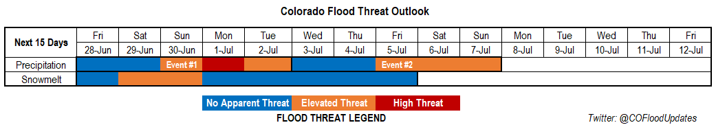
Looks like that summer atmospheric pattern is finally here to stay. The polar jet has finally pulled to the north, which has allowed some very hot temperatures to fester over the state since Monday. The 5580m line (weak ridge) will remain well to the north of the state through next Monday with the main axis to our east. This will continue southwest flow aloft and keep hot temperatures in the forecast through this weekend. Movement of the axis further east will allow ample low level moisture to return to the state, and may pull in remnants of Tropical Storm Alvin (off the coast of Mexico) over the southwest corner of the state as soon as Friday. By Sunday evening, flow will start to become more zonal as the ridge breaks down, and a weak cold front will pass through the state overnight. Westerly flow aloft through Tuesday will keep high PW values over eastern Colorado. Flow aloft turns to the northwest after Tuesday, which should end Event #1.
Not much, if any time between Event #1 and Event #2. Ample moisture remains in place after Tuesday for scattered afternoon storms, but the flood threat should decrease. By the holiday weekend, the upper level ridge will set back up with the ridge of the axis possibility setting up to the east once again. This would allow low level moisture to rotate around the high and return the flood threat. Still quite a bit of uncertainty at this time, but overall, doesn’t look like there will be much dry or too cool of temperatures this next forecast period.
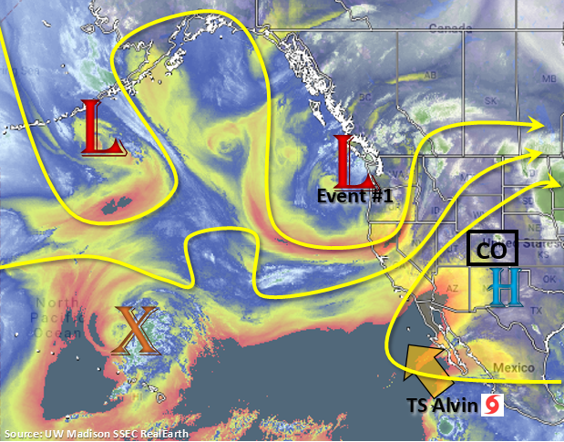
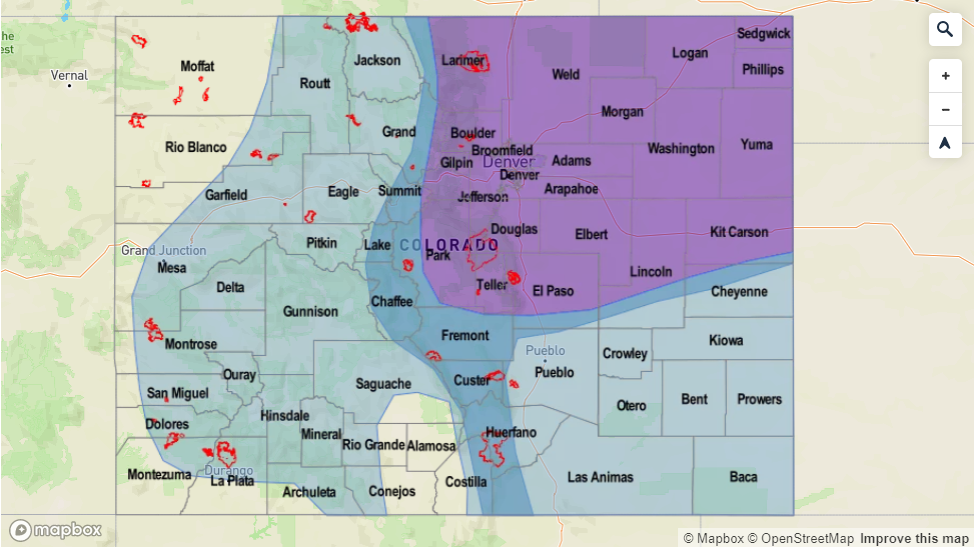
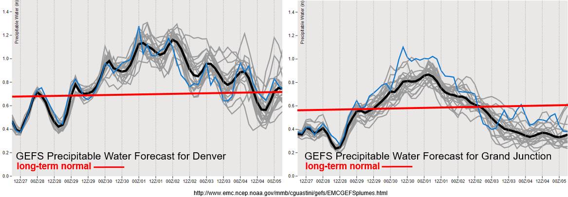
PW values look to increase statewide to much above average values for this time of year by this weekend, and then last through next Tuesday. Monday’s FTO’s PW values showed an increase, but not with the certainty, magnitude and timing of the latest GEFS runs. This will return the flood threat both east and west of the Continental Divide and increase the threat level to an Elevated/High threat at the end of this weekend. It has been dry and hot over western Colorado with critical fire weather yesterday, today and again tomorrow. The absorption of moisture into the westerly flow from Tropical Storm Alvin over southwest CO begins on Friday, which should reduce fire danger and increase the chances for measurable rain this weekend. The 416 burn area will be monitored closely due to the uptick in moisture from Saturday to Monday. To the east, PW values peak well above the 1 inch mark on Sunday and Monday. Reminder that the 1 inch PW value is a good indicator of heavy rainfall if both lift and instability are also available. Slow steering winds under the ridge over eastern Colorado will also allow storms to drop heavier accumulations. Recent burn areas will be extra susceptible to flooding during Event #1. After Monday, dry weather is expected to return to western Colorado with the ridge axis to our west. Moisture will also briefly decrease to more seasonable values over eastern Colorado, so there is No Apparent Threat at this time.
Snowpack:
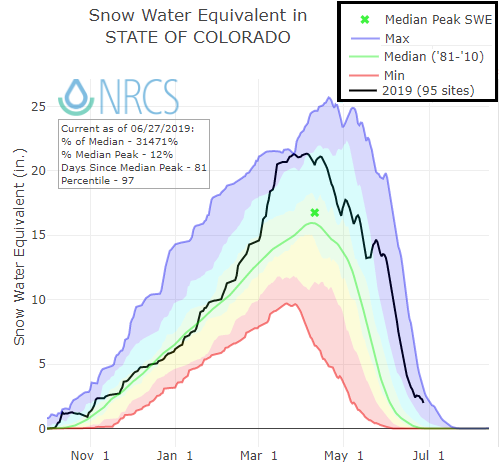
The flooding threat has decreased over the state the last couple of days with only one gage remaining at Action stage this morning (Rio Grande at Alamosa). The flow is anticipated to remain steady at the gage with only a slight increase this weekend thanks to multiple days of hot temperatures. Taking a look at the statewide SWE below, you can pick out the spring snow storms that have occurred over the last couple months and have stalled the melting process (and even added to SWE). While we will come close to the 1995 record for longest lasting SWE, we likely won’t beat it with summerlike temperatures forecast. RFCs (River Forecast Centers) are forecasting another rise in smaller, high-elevation rivers and streams by later this weekend, which may cause a couple AHPS gages to reach Action stage. Rain forecasts will be monitored closely during this peak as some heavier, widespread rainfall will be possible. This may cause some minor flooding issues while the rivers are swollen from snowmelt, but at this time, no major riverine flooding is anticipated. As anticipated, there are currently no NWS Areal Flood Advisories or Warnings. This will likely be the last FTO with the snowpack update, but riverine flooding will continue to be monitored throughout the season.
Event #1: Friday (6/28) – Tuesday (7/2)
No Apparent Threat – High Threat as eastward movement of a weak ridge allows ample low level moisture from the Gulf of Mexico and Tropical Storm Alvin to move into the state.
Deep moisture will return to the state beginning this weekend. This will return the flood threat as heavy rainfall with slow steering winds combine for a High threat on Monday. Storms will initiate over the mountains each afternoon and will likely be confined to that area and immediate adjacent plains through this event. The main reason for this is the only forcing mechanism available will be the diurnal upslope pattern. Storms will likely survive best over the Palmer and Raton Ridges as they move east. By Sunday, storms over the mountains will be capable of producing widespread, heavy rainfall with very high PW values anticipated over the state. This could easily cause some flooding issues, especially over recent burn scars in the Southeast Mountains and San Juan/Central Mountains. Thunderstorms chances increase for the plains on Monday and Tuesday. These storms will also be capable of producing heavy rainfall as well as some severe weather over the Northeast Plains thanks to passing cold fronts adding dynamics to the atmosphere. Still quite a bit of uncertainty with how each day will unfold Sunday-Tuesday, so please tune back into the daily FTB for the latest details.

Event #2: Wednesday (7/3) – Sunday (7/7)
No Apparent Threat/Elevated Threat northwest flow brings a brief break in heavy rainfall before the next ridge sets up and potentially shifts slightly to the east allowing gulf moisture to increase over eastern Colorado.
Models hint at a ridge rebuilding north of Colorado for the holiday weekend. This would return hot temperatures to the forecast statewide. Eastward movement of the ridge on Saturday night, along with passing shortwaves rotating around the high, would return the flood threat. High PW values would be advected north over eastern Colorado in this scenario. Moisture is also expected to increase over western Colorado again, so rainfall will likely return to the forecast there as well. Still quite a bit of uncertainty this far out. Tune back into the FTO on Monday for the latest details on rainfall chances for the 4th of July weekend.