Issue Date: Monday, July 1st, 2019
Issue Time: 2:35PM MDT
Valid Dates: 7/2 – 7/16
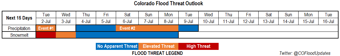
With the jet well to the north, an off and off ridging pattern will set up over the state. The first event of this FTO will be the last day from Event #1 from Thursday’s FTO. The weak ridging pattern present today is expected to persist through tomorrow. This atmospheric pattern, with the ridge axis slightly to the east, has funneled in a very moist air mass over eastern Colorado. There is a break after Event #1 as the ridge builds north and west of the state on Wednesday. Outside of some weak, high elevation storms with the diurnal flow, it should be a pleasant and warm day.
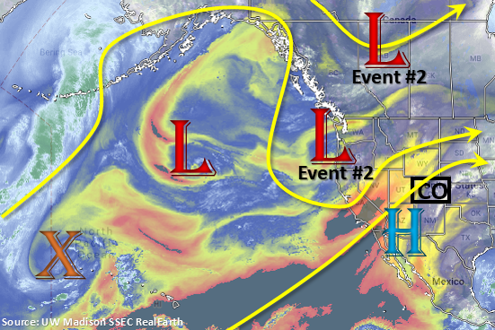
By Thursday, Event #2 begins as an upper level low over the Pacific Northwest drops south and moves east into the desert southwest. This will return southwest flow aloft and help rotate some mid-level energy across the state each afternoon, which should help increase the coverage of storms over the mountains and adjacent plains. Additional thunderstorm activity will be possible over the eastern plains with a lee trough setting up on Thursday and Friday. By Saturday, the next surge of low level moisture occurs as the next low over the Pacific Northwest pushes east. With slight eastward movement of the ridge, surface flow will again tap into Gulf of Mexico moisture. Models are also hinting at a cold front dropping through the state on Friday night, which should help increase low level moisture over the area for an increase in storm activity on Saturday over the mountains. Thus, there is an Elevated Threat from Saturday to Monday before northwest flow begins to push the high moisture south and east. Another cold front looks to drop through the state on Tuesday or Wednesday thanks to the northwest flow aloft. Models showing more stability behind this feature, so storm activity should then be isolated and confined to the eastern mountains.
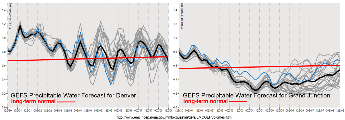
We’re nearing the point in time that PW values have a quick increase in climatology, which marks the onset of the North American Monsoon (NAM). Models are beginning to hint at the NAM regime taking over about 1.5 to 2 weeks from now. For this FTO, the GEFS PW plumes are showing quite the active pattern over the next week east of the Continental Divide. Tomorrow, PW values look to hang on at or slight above 1 inch. With slow steering winds in place for another day, an Elevated flood threat has been issued. PW values diverge from member to member after Wednesday, which shows the uncertainty for Event #2. However, with the upward trend in the models going into the holiday weekend, an Elevated flood threat has been issued for Saturday, Sunday and Monday.
To the west, remnants of Alvin are pushed out of the area with dry southwest flow rather rapidly. This will decrease PW values to well below climatology and limit the chances for measurable rain until this weekend. These dry spells and lack of rainfall are not too uncommon for the area this time of year, since the majority of western Colorado receives the bulk of its precipitation during July and August from the NAM. With a southwest to northeast oriented jet near the western border on Thursday and Friday, there may be increase in fire danger.
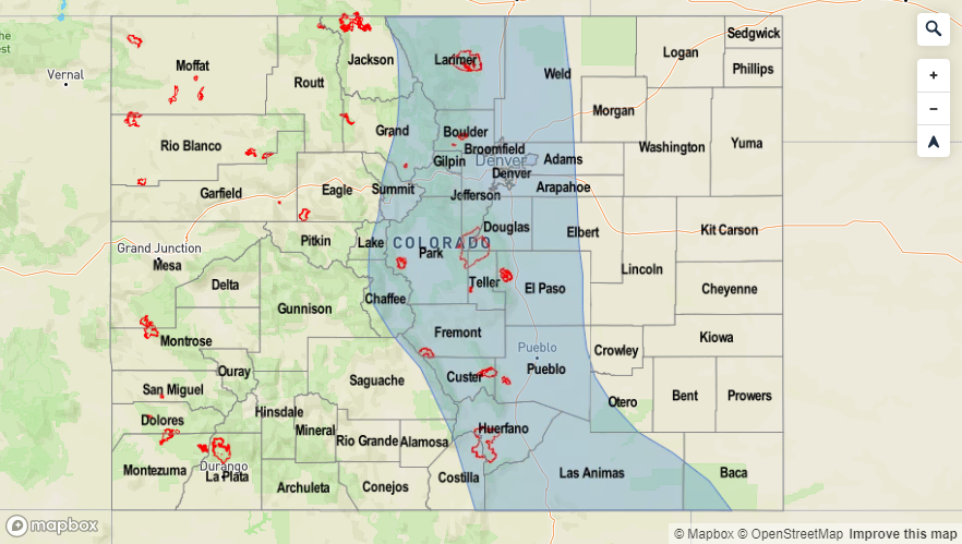
Snowpack:
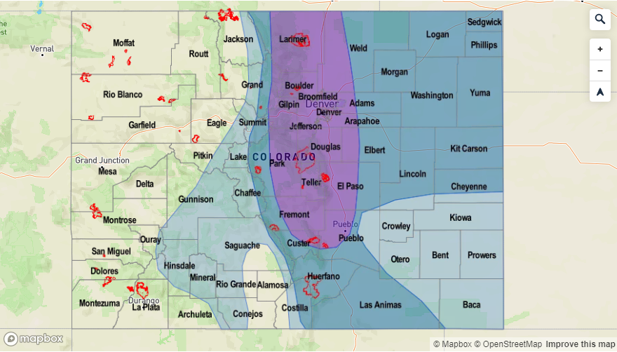
As anticipated, the RFCs (River Forecast Centers) forecast of higher streamflows this weekend into this week came to fruition. This was partially due to snowmelt and partially due to widespread rain yesterday adding to the swollen rivers. Additionally, there was a release at Pueblo Dam, which cause some minor lowland flooding at Avondale. Runoff from yesterdays’ storms really spiked some gages, so with heavier rainfall anticipated today, another round of storms tomorrow and saturated soils, a High threat has been issued for bankfull, high elevation streams and rivers. This includes the upper Colorado and Arkansas Rivers. While only minor lowland flooding is anticipated, the swift movement of the rivers will likely cause banks to become unstable and increase debris in the water. Please use extreme caution this next week with all water activities. For the latest on the riverine flood threat, check out the real-time AHPS gage heights and follow your local NWS office for warnings and advisories.
Event #1: Tuesday (7/2)
Elevated Threat as low level moisture remains over eastern Colorado and slow steering winds will promote local heavy rainfall for another day.
Storms for the most part will be confined to the higher terrains tomorrow. There will likely be some activity over the adjacent eastern plains along the Palmer and Raton Ridges. Without any extra mid-level energy, the mountains and ridges will provide the lift for the storms. Rainfall rates will likely be more gradual than today, so widespread flooding is not anticipated. However, rain rates are expected to be high enough to cause flooding issues over recent burn scars in the Southeast Mountains. These areas will be susceptible to flash flooding and mud flows/debris slides for one more day. Please tune into the FTB tomorrow for more details. Elsewhere over the mountains, expect an increase in runoff due to two days of rainfall. This will also increase the chances for mud flows and debris slides under stronger storms. High rivers and streams should also be monitored closely, and extreme caution should be used around high and rushing water as banks are likely unstable.

Event #2: Thursday (7/4) – Tuesday (7/9)
No Apparent Threat/Elevated Threat southwest flow returns and a push of the ridge eastwards allows Gulf of Mexico moisture to return to the eastern plains.
Quite a bit of divergence in the models and members for this weekend, but with a trend of an upward tick in moisture, there will be an Elevated flood threat for the 4th of July weekend. A ridge begins to build over the state for the first part of the week. Then as the ridge is pushed east with the trough, an influx of higher PW values over eastern Colorado will be likely. A lee trough sets up on Thursday and Friday, so some severe weather may be possible along the eastern border. The main threats will be gusty winds and large hail. Hard to tell where the moisture will set up over the eastern plains, but storms in the area will likely produce at least moderate rainfall rates with a chance for heavy rainfall. Post frontal upslope flow on Saturday should cause more numerous storms over the mountains, but activity is not anticipated for the adjacent plains at this time. Storm activity on Sunday and Monday is forecast to spill into the adjacent plains with stronger steering flows and an increase in mid-level energy. Please tune back into the FTO on Thursday as models will come into better agreement for the pattern this weekend.