Issue Date: Monday, June 24th, 2019
Issue Time: 2:40PM MDT
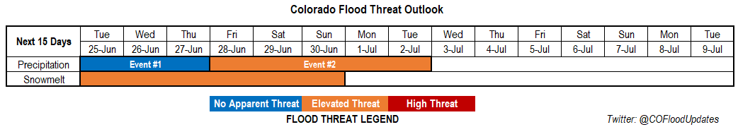
Valid Dates: 6/25 – 7/9
More summer-like temperatures will arrive this week, which are welcome after a cold and wet weekend. The trough that brought up to a foot of snow to portions of the high country has now pushed east with westerly winds aloft and pressure rises filling in behind it. A ridge will begin to move over the state from the west this afternoon and will build in strength throughout the week. At the same time, an upper low will make its move south and sit over Washington/Oregon, which will reinforce the ridging pattern over the state. Expect the return of warmer temperatures to the forecast as southwest winds pull in a dry, warm air mass over the state. Thunderstorms will still be expected over the mountains each afternoon, but with limited coverage. On Wednesday and Thursday, some stronger storms may be possible over the eastern plains as a lee trough sets up.
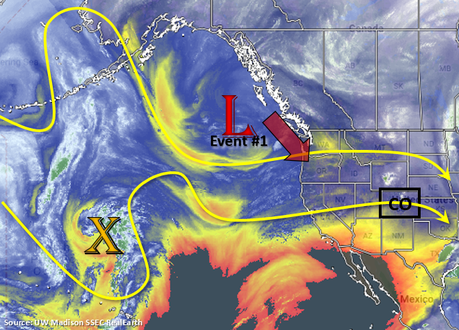
The next event begins this weekend as the upper low tracks to the north of the state and more moisture is pulled in east and west (slight less) of the Continental Divide. The arrival of upper level dynamics in the form of shortwaves should cause an increase in afternoon storm intensity and coverage. By Tuesday, flow will shift back to the northwest as the trough completely passes through, which should bring the next break in rainfall and slight cooling to high temperatures on Wednesday.
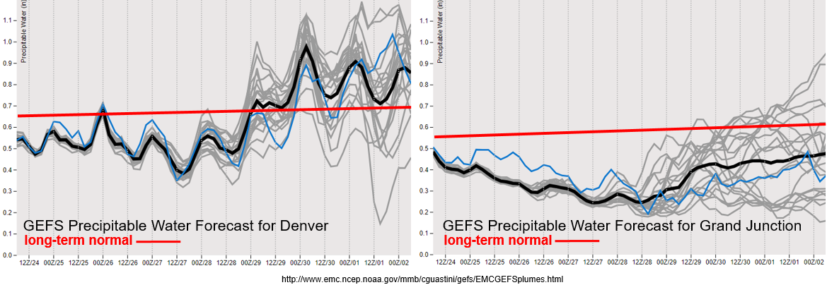
For the start of this next FTO, PW values are looking to remain below average with significantly below average values over western Colorado. Thus, storms that form over the mountains and eastern plains each afternoon should have limited coverage with the severe threat being confined to the far eastern plains on Wednesday and Thursday. PW values over the eastern plains will remain below 1 inch and with slower storm movement under the ridge, some moderate accumulation may be possible. Storms that are able to form over the western slope will likely produce some gusty winds with inverted-V soundings. So at this time, there is No Apparent Threat. Going into the weekend, there is an uptick in available moisture with a slight eastward shift in the ridge. The GEFS picks up this increase in Gulf of Mexico moisture over eastern Colorado; however, there is still quite a bit of uncertainty when looking at estimated PW values over Grand Junction (large spread). Nonetheless, forecasting strong moisture return over eastern Colorado, which will cause an Elevated flood threat with an emphasis on Saturday and Sunday.
Snowpack:
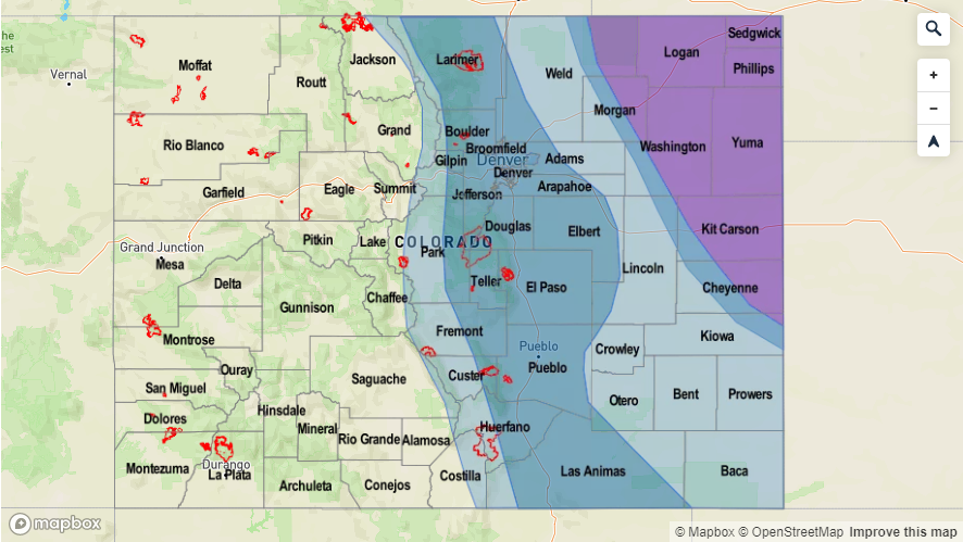
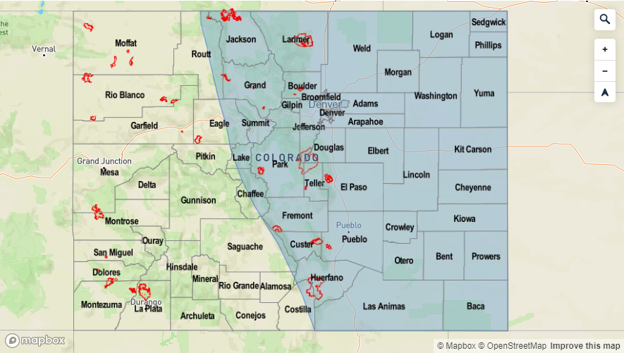
Flooding has increased over northern Colorado thanks to numerous rounds of continuous precipitation from the last storm system. On Sunday, there were several reports of rural roads underwater or washed out from the combination of snowmelt and runoff in central Jackson County. Elevated rivers in these areas will likely recede today to more manageable levels. However, warm temperatures may cause some minor flooding issues by the end of the week for smaller, high elevation streams. This is especially true if this last round of snow melts quickly up north. The Arkansas River will also likely see a ramp up in flows during the latter part of this week thanks to the summer temperatures. Therefore, on and off dam releases at Pueblo Dam will likely continue to cause problems from Avondale to La Junta. The flow on the upper branches of the Rio Grande are forecast to decrease, although elevated flows will likely continue (Action stage) throughout the work week further downstream near Alamosa. Over the Central Mountains, smaller high-elevation rivers and streams will be monitored closely later this week as this area, too, has some snow melt to be realized. Overall, no major flooding issues are anticipated at this time with a quiet atmospheric pattern in place. The only NWS Areal Flood Warning (as of 2PM), is for the area downstream of Pueblo Dam to Avondale. Be sure to tune back in Thursday for the outlook to be updated for this weekend. You can also find the latest Areal Flood Warnings in the daily FTB.
Event #1: Tuesday (6/25) – Thursday (6/27)
No Apparent Threat as a ridge builds over the state and dry, warm southwest flow limits moisture for only scattered afternoon storms.
Overall, should be a quiet and hot work week with some scattered afternoon storms over the mountains and eastern plains each day. The best chance for rainfall over western Colorado will be on Friday, but most of the accumulation will be along or near the Continental Divide. Fire weather concerns increase for the southwestern border later this week as the jet become oriented from south to north over the area. Strong winds could mix to the surface with the tightening gradient as the next system approaches from the west. Critical fire weather is not anticipated at this time with the green vegetation. Moderate rainfall and severe weather chances increase for the eastern plains Wednesday and Thursday as a lee trough sets up. Deeper moisture will likely reside to the east, so flooding is not anticipated at this time.

Event #2: Friday (6/28) – Tuesday (7/2)
Elevated Threat a ridge shifts slight to the east and gulf moisture increases over eastern Colorado.
Models hint at the strong trough moving to our north at the end of this week into this weekend. This will cause a flux of moisture over eastern Colorado with a slight eastward shift of the ridge. In addition to the moisture return, some mid-level energy will push over the state, which should increase the coverage of storms. Slower steering winds under the ridge may allow for some decent accumulations on Saturday and Sunday, so there is an Elevated flood threat with Event #2. As for western Colorado, there is still quite a bit of spread as to how much moisture returns to the area. At this time, Friday will likely have the most coverage of storms, although accumulation will be confined to the mountains. A cold front looks to move through on Monday, which could cause some severe weather over the Northeast Plains if timed correctly with peak heating. Still quite a bit of uncertainty this far out, so there is low confidence in this forecast. By Tuesday, expect some slightly cooler high temperatures with some residual moisture still available for the last round of storms. Northwest flow behind the system will push the better moisture to the south and east of the state by Wednesday with high temperatures dropping off behind the front.